
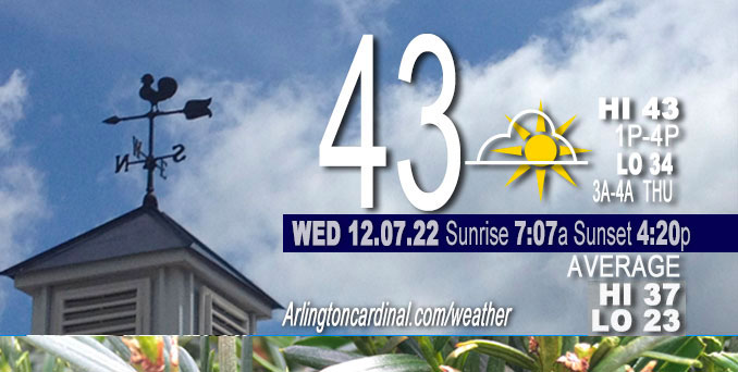
WEDNESDAY Hi 43, fog early, partly sunny, winds N to WNW to N to NNE, 2 to 8 to 6 MPH
NWS CHGO | NWS HRLY | /NWSchicago | 🌡
ARLINGTON HEIGHTS WEATHER
▴ forecast7 (Arl. Hts.) | RADAR | WIDE RADAR
⏪ Hrly Data Table | Hrly Future Graph ⏩
IMPORTANT NOTE ON NWS DATA
⏪ Hrly Data Table | Hrly Future Graph ⏩
======================
Wednesday and Wednesday Night …
Weather Hazards expected…
Hazardous Weather Outlook
National Weather Service Chicago/Romeoville IL
341 AM CST Wed Dec 7 2022
Winnebago-Boone-McHenry-Lake IL-Ogle-Lee-De Kalb-Kane-DuPage- La Salle-Kendall-Grundy-Kankakee-Livingston-Iroquois-Ford- Northern Cook-Central Cook-Southern Cook-Northern Will- Southern Will-Eastern Will-Lake IN-Porter-Newton-Jasper-Benton- 341 AM CST Wed Dec 7 2022 /441 AM EST Wed Dec 7 2022/
This Hazardous Weather Outlook is for portions of North Central Illinois…Northeast Illinois and Northwest Indiana.
Weather hazards expected…
Significant Fog Risk this morning.
DISCUSSION…
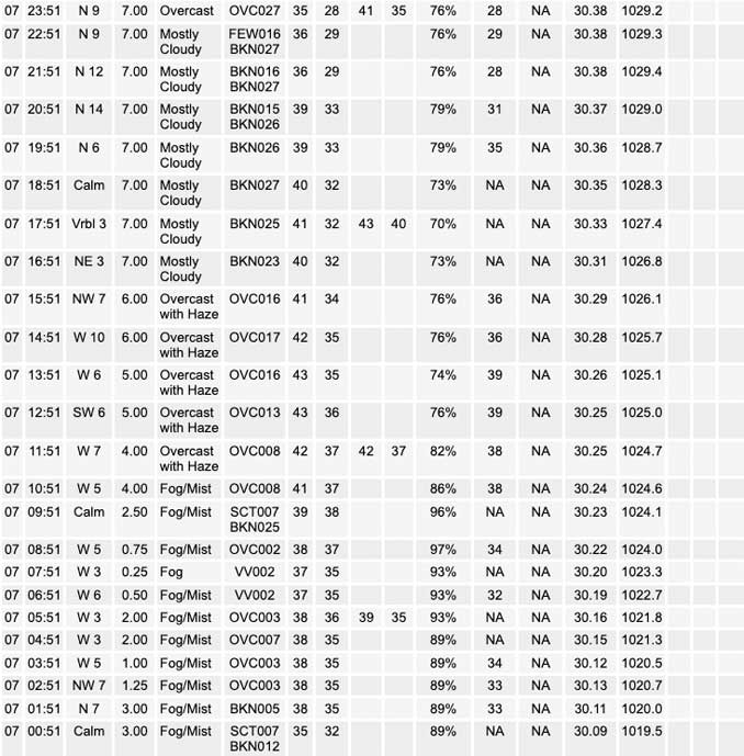
Areas of dense fog will affect parts of northern Illinois mainly west and northwest of Chicago this morning.
Areas of fog will continue through mid morning and there may be pockets of locally dense fog. Be alert for rapid changes in visibility when driving this morning. Reduce speed and use low beam headlights when driving in fog.
Hello mobile users! If you encounter mobile “unfriendly” weather page, turn your phone sideways for a better view.
======================
O’HARE FORECAST …
Forecast Beginning Wednesday, Dec. 07, 2022
Wednesday: Patchy fog before 11am. Otherwise, mostly cloudy, with a high near 44. Light and variable wind becoming northwest 5 to 10 mph in the afternoon.
Wednesday Night: Mostly cloudy, with a low around 34. North wind 5 to 10 mph.
Thursday: A 30 percent chance of rain after 4pm. Cloudy, with a high near 43. East wind 5 to 10 mph, with gusts as high as 15 mph.
Thursday Night: Rain, mainly after 7pm. Low around 37. East wind 10 to 15 mph, with gusts as high as 20 mph. Chance of precipitation is 90%.
Friday: Rain, mainly before 1pm. High near 42. East northeast wind 10 to 15 mph, with gusts as high as 20 mph. Chance of precipitation is 90%.
Friday Night: A 30 percent chance of rain before 7pm. Mostly cloudy, with a low around 35.
Saturday: A 20 percent chance of rain after 1pm. Mostly cloudy, with a high near 43.
Saturday Night: Mostly cloudy, with a low around 33.
Sunday: Partly sunny, with a high near 44.
Sunday Night: Mostly cloudy, with a low around 32.
Monday: Mostly cloudy, with a high near 46.
Monday Night: A chance of rain. Mostly cloudy, with a low around 38.
Tuesday: Rain likely. Cloudy, with a high near 51.


CHICAGOWEATHERSTATION.COM

ChicagoWeatherStation.com I O’Hare Normal Temps/Precip I O’Hare Record Temps, Precip, Snow
LIVE RADAR | STORM TRACKS | UNISYS US IR SAT | UNISYS Midwest IR SAT | UNISYS More IR SAT
WunderMap® with Temperature/Wind Data || Google: Arlington Heights Area Temps | US TEMPS
Full Screen Motion Weather Radar (Wunderground.com)
Midwest Cloud Cover with Arlington Heights Weather Forecast
ChicagoWeatherStation.com I O’Hare Normal Temps/Precip I O’Hare Record Temps, Precip, Snow
SUNLIGHT DATA FOR SECURITY, TRAFFIC SAFETY, AND SPORTS
SunCalc.net data with solar azimuth and trajectory, times for dawn, sunrise, solar noon, sunset, dusk …
NIGHT SKY THIS MONTH …
Backyard stargazers get a monthly guide to the northern hemisphere’s skywatching events with “Tonight’s Sky.” Check the night sky objects for this month and past months in the playlist from the Space Telescope Science Institute YouTube channel (Musical track The Far River written by Jonn Serrie, from the album And the Stars Go With You courtesy of New World Music Ltd).
Get updates from The Cardinal ALL NEWS FEEDS on Facebook. Just ‘LIKE’ the ‘Arlington Cardinal Page (become a fan of our page). The updates cover all posts and sub-category posts from The Cardinal — Arlingtoncardinal.com. You can also limit feeds to specific categories. See all of The Cardinal Facebook fan pages at Arlingtoncardinal.com/about/facebook …
Help fund The Cardinal Arlingtoncardinal.com/sponsor
Area Forecast Discussion
National Weather Service Chicago/Romeoville, IL
538 AM CST Wed Dec 7 2022
.SHORT TERM… Issued at 311 AM CST Wed Dec 7 2022
Through Thursday…
Short term forecast concerns are fog trends this morning, and the return of rain chances Thursday afternoon. Have expanded dense fog advisory further into the western and northern Chicago metro area.
Fog has developed and expanded overnight west and northwest of Chicago, in an area which remains in a low level moisture gradient associated with yesterday`s dissipating cold front. Various areas and thicknesses of low level stratus overcast have made anticipating the fog development areas a little tricky, though the aggregate of high-res visibility guidance seems to be doing a halfway decent job of identifying areas along/north of I-88 across northern IL this morning. Exception for now is areas back toward the I-39 corridor, where thicker stratus deck had advected in from the southwest and has helped to keep fog in check so far. Recent expansion has been along the eastern periphery of the denser fog into parts of DuPage, southwest Lake and northwest Cook counties, and with GOES 12.3-10.35um IR product showing continued eastward expansion have elected to add Lake, DuPage, northern Cook, Kendall and northern Will counties to the dense fog issued a couple of hours ago. Winds should eventually pick up a bit from the northwest as surface high pressure spreads across the upper Mississippi Valley, Ontario and the northern Great Lakes, though with late sunrise times and low sun angle of early December will likely see fog linger a few hours beyond sunrise.
While some partial clearing is possible today especially across far west and northwest parts of the forecast area, the large area of stratus upstream across Wisconsin will tend to limit clearing of skies as low level winds gradually veer north and then north- northeast through this evening. With little air mass change however, temperatures will still range above seasonal averages with afternoon highs from around 40 along the IL/WI border to the mid 40s for the most part farther south. Lingering cloud cover tonight will hel Pkeep lows in the upper 20s/low-mid 30s from north to south.
Attention then turns to a mid-level short wave trough currently evident in water vapor imagery over California/Nevada. This trough is progged to lift northeast across the central and southern Rockies and into the Plains by Thursday afternoon, with attendant surface low developing into the southeast Kansas vicinity by evening. Forcing through the afternoon is focused largely to our southwest across IA/MO and western IL, with east-northeasterly flow maintaining dry advection off the strong surface high to our north. Forecast soundings do gradually saturate low levels from southwest to northeast by evening with light rain developing especially across the central and southern parts of the cwa. Afternoon temps again look to reach the 40-45 degree range, so all precipitation is expected to be rain.
Ratzer/NWS Chicago
