
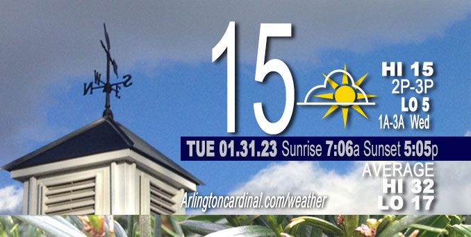
Tuesday Hi 15, partly cloudy, clearing after 3p, winds W to SW, 6 to 9 to 8 MPH
NWS CHGO | NWS HRLY | /NWSchicago | 🌡
ARLINGTON HEIGHTS WEATHER
▴ forecast7 (Arl. Hts.) | RADAR | WIDE RADAR
⏪ Hrly Data Table | Hrly Future Graph ⏩
IMPORTANT NOTE ON NWS DATA
⏪ Hrly Data Table | Hrly Future Graph ⏩
======================
Tuesday and Tuesday Night …
Weather Hazards expected …
Limited Excessive Cold Risk this morning and tonight.
DISCUSSION…
Sub-zero air temperatures and any wind will result in wind chills of fifteen below zero to locally twenty below zero this morning and tonight through early Wednesday across interior northern Illinois. Coldest temperatures over the deepest snow cover area of northern Illinois near Rockford and McHenry County.
Daily low temperatures and daily high temperatures are on the way up. We’re gaining about 2 minutes of daylight every day in the progression toward vernal equinox, March 20, 2023.
======================
O’HARE FORECAST …
Forecast Beginning Tuesday, Jan. 31, 2023
Tuesday: Mostly sunny, with a high near 15. Wind chill values as low as -6. West wind 5 to 10 mph.
Tuesday Night: Clear, with a low around 5. Wind chill values as low as -8. West southwest wind 5 to 10 mph.
Wednesday: Sunny, with a high near 29. Wind chill values as low as -6. Southwest wind 5 to 15 mph, with gusts as high as 20 mph.
Wednesday Night: Partly cloudy, with a low around 17. Southwest wind 10 to 15 mph, with gusts as high as 25 mph.
Thursday: Sunny, with a high near 30. West southwest wind around 15 mph, with gusts as high as 20 mph.
Thursday Night: Mostly clear, with a low around 4.
Friday: Mostly sunny, with a high near 14.
Friday Night: Mostly cloudy, with a low around 8.
Saturday: Mostly cloudy, with a high near 32. Breezy.
Saturday Night: Mostly cloudy, with a low around 28. Breezy.
Sunday: Partly sunny, with a high near 35.
Sunday Night: Mostly cloudy, with a low around 25.
Monday: Mostly cloudy, with a high near 40.


CHICAGOWEATHERSTATION.COM

ChicagoWeatherStation.com I O’Hare Normal Temps/Precip I O’Hare Record Temps, Precip, Snow
LIVE RADAR | STORM TRACKS | UNISYS US IR SAT | UNISYS Midwest IR SAT | UNISYS More IR SAT
WunderMap® with Temperature/Wind Data || Google: Arlington Heights Area Temps | US TEMPS
Full Screen Motion Weather Radar (Wunderground.com)
Midwest Cloud Cover with Arlington Heights Weather Forecast
ChicagoWeatherStation.com I O’Hare Normal Temps/Precip I O’Hare Record Temps, Precip, Snow
SUNLIGHT DATA FOR SECURITY, TRAFFIC SAFETY, AND SPORTS
SunCalc.net data with solar azimuth and trajectory, times for dawn, sunrise, solar noon, sunset, dusk …
NIGHT SKY THIS MONTH …
Backyard stargazers get a monthly guide to the northern hemisphere’s skywatching events with “Tonight’s Sky.” Check the night sky objects for this month and past months in the playlist from the Space Telescope Science Institute YouTube channel (Musical track The Far River written by Jonn Serrie, from the album And the Stars Go With You courtesy of New World Music Ltd).
Get updates from The Cardinal ALL NEWS FEEDS on Facebook. Just ‘LIKE’ the ‘Arlington Cardinal Page (become a fan of our page). The updates cover all posts and sub-category posts from The Cardinal — Arlingtoncardinal.com. You can also limit feeds to specific categories. See all of The Cardinal Facebook fan pages at Arlingtoncardinal.com/about/facebook …
Help fund The Cardinal Arlingtoncardinal.com/sponsor
Area Forecast Discussion
National Weather Service Chicago/Romeoville, IL
521 AM CST Tue Jan 31 2023
.SHORT TERM… Issued at 154 AM CST Tue Jan 31 2023
Through Wednesday…
Main concern:
* Another night of very cold temperatures tonight, especially over the deepest snow cover area of northern Illinois
1034 mb high pressure is centered over the Quad Cities as of this writing and the surface high center will gradually move east and then southeast through tonight. Bundle up this morning, as air temperatures will be generally in the single digits above and below zero, with about -10F for favored cold spots west of the Fox Valley. Winds will be light, but any wind in the colder areas will knock wind chills down as low as the minus teens. Snow cover over much of the area and the surface high position will limit mixing heights today, plus cold advection aloft will only start to ease this afternoon. Thus despite plenty of sun except for a patch of mid clouds, highs will only recover to the single digits and low teens over deepest snow cover and mid to high teens in Chicago and locales south of I-80 (isolated 20F far southeast).
Skies will be clear/mostly clear tonight with high confidence and the surface high will be essentially overhead at sunset. This will set the stage for strong radiational cooling, likely more favorable than early this morning. Only offsetting element will be a modest uptick in warm advection aloft overnight and the surface high sliding southeast. Conceptually, this should result in plummeting temps in the evening, especially over favored cold spots and then perhaps steady to slowly rising temps in the pre-dawn through early Wednesday morning. Have forecast lows as cold as high minus single digits and wouldn`t be surprised if ob sites like Rochelle (RPJ) and Sugar Grove (ARR) tag double digits below zero, particularly if winds quickly go calm early this evening. The expected light winds again tonight will preclude the need for a Wind Chill Advisory, but certainly will be a frigid start to Wednesday well outside of Chicago. Lows in the city and rest of the CWA should be in the single digits above zero.
As the surface high slides farther southeast on Wednesday, southwesterly winds will increase some, along with WAA aloft. Generally full sun should support highs in the upper 20s-low 30s over areas with little or no snow cover and in the city, while the deeper snow cover should limit those spots to the low-mid 20s.
Castro/NWS Chicago
