
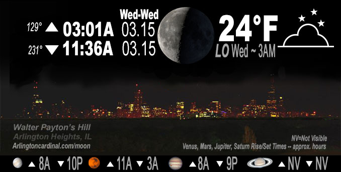
🌘 🌑 🌗 🌕 Waning Crescent Moon, sky cover overnight Tue. to Wed. <6%, winds NW to E to S, 5 to 3 to 6 MPH, Low 24, 3a to 7a
NWS CHGO | NWS HRLY | /NWSchicago | 🌡
ARLINGTON HEIGHTS WEATHER
▴ forecast7 (Arl. Hts.) | RADAR | WIDE RADAR
IMPORTANT NOTE ON NWS DATA
Hello mobile users! If you encounter a mobile “unfriendly” weather page, turn your phone sideways for a better view.
======================
NIGHT FORECASTS …
NOTE: Keep in mind lunar rise and set times don’t always correspond with night weather and early morning lows because on some days during the month the moon is visible in the sky predominantly during the daytime hours.
Overnight Tuesday/Wednesday …
No Weather Hazards expected
Temps tonight will moderate slightly by a few degrees compared to last night in response to sunny skies across the region earlier Tuesday. Initially forecast was plotting 20°F or even upper teens, but currently forecast low in Arlington Heights is around 24°F.
DISCUSSION…
A compact mid-level wave over eastern South Dakota should bring a brief period of broken mid-level clouds around daybreak
Wednesday.
======================
O’HARE FORECAST …
Forecast Beginning Tuesday Night, Mar. 14, 2023 …
Tuesday Night: Clear, with a low around 21. Northeast wind around 5 mph becoming south after midnight.
Wednesday: Mostly sunny, with a high near 51. South southwest wind 10 to 15 mph, with gusts as high as 25 mph.
Wednesday Night: A 20 percent chance of rain after 1am. Mostly cloudy, with a low around 41. South southwest wind 10 to 15 mph, with gusts as high as 30 mph.
Thursday: Rain, mainly after 1pm. High near 48. South southwest wind around 15 mph, with gusts as high as 25 mph. Chance of precipitation is 90%.
Thursday Night: Rain. Low around 37. Breezy. Chance of precipitation is 100%.
Friday: A chance of rain and snow, mainly before 1pm. Mostly cloudy, with a high near 38. Breezy. Chance of precipitation is 30%.
Friday Night: Mostly cloudy, with a low around 22. Breezy.
Saturday: Mostly cloudy, with a high near 30. Blustery.
Saturday Night: Mostly cloudy, with a low around 22.
Sunday: Sunny, with a high near 37.
Sunday Night: Mostly clear, with a low around 26.
Monday: Sunny, with a high near 44.
O’Hare forecast archive and hourly weather observations archive are available HERE on the CARDINAL NEWS Magazine.
Arlingtoncardinal.com/moonphases
Arlingtoncardinal.com/nightsky
NIGHT SKY THIS MONTH …
Check the night sky objects for this month and past months in the playlist from the Space Telescope Science Institute YouTube channel Backyard stargazers get a monthly guide to the northern hemisphere’s skywatching events with “Tonight’s Sky” (Musical track The Far River written by Jonn Serrie, from the album And the Stars Go With You courtesy of New World Music Ltd. Musical track The Far River written by Jonn Serrie, from the album And the Stars Go With You courtesy of New World Music Ltd).
Telephoto lens, ISO 100, f/11, Shutter Speed 1/100 to 1/125 for the Moon.
Get updates from The Cardinal ALL NEWS FEEDS on Facebook. Just ‘LIKE’ the ‘Arlington Cardinal Page (become a fan of our page). The updates cover all posts and sub-category posts from The Cardinal — Arlingtoncardinal.com. You can also limit feeds to specific categories. See all of The Cardinal Facebook fan pages at Arlingtoncardinal.com/about/facebook …
Help fund The Cardinal Arlingtoncardinal.com/sponsor
Telephoto lens, ISO 1600, f/11, Shutter Speed 2.5″ for the skyline. The skyline exposure was toned down, and brightness and contrast was adjusted in Photoshop.
Area Forecast Discussion
National Weather Service Chicago/Romeoville, IL
1203 AM CDT Wed Mar 15 2023
.SHORT TERM… Issued at 245 PM CDT Tue Mar 14 2023
Through Wednesday night…
A break between active weather will prevail through Wednesday ahead of another storm system Thursday. As an upper ridge shifts into the Missouri River Valley this afternoon, surface high pressure will drift over the Mississippi River Valley and across the CWA through tonight. Temps tonight will moderate slightly by a few degrees compared to last night in response to sunny skies across the region today and veering low-level flow overnight. A compact mid-level wave over eastern South Dakota should bring a brief period of broken mid-level clouds around daybreak Wednesday. Modest 600-400hPa lapse rates within an overall poor moisture profile may squeeze out some virga during this time.
Mid and upper-level cloud cover will steadily increase Wednesday within deep but broad isentropic ascent ahead of Thursday`s system. A 50 knot 925 hPa LLJ veering into northern Illinois should supply some continued SW gustiness Wednesday night while quickly increasing low-level moisture transport develops initial spotty showers by sunrise Thursday.
Kluber/NWS Chicago
236 AM CDT Wed Mar 15 2023
.SHORT TERM… Issued at 235 AM CDT Wed Mar 15 2023
Through Thursday Night…
Key Messages:
* Breezy south winds today and Thursday ushering in highs a few degrees above mid March normals
* Rain spreading in Thursday during the late morning and afternoon and ending Thursday night from west to east
Satellite water vapor imagery shows broad scale upper level ridging sliding its way eastward over the area, with the embedded exception of a dampening short wave across eastern Iowa. This wave will provide some mid clouds at daybreak for northern Illinois that will quickly fade. The surface pressure gradient will tighten today well in advance of lee-side cyclogenesis in the western Plains, and the result will be southerly winds gusting to 20 to 25 mph this afternoon. The 925 mb temperatures will swing to the plus side of 0C, supportive of highs around 50F. The last of the snow cover in the far northern CWA should melt today but may thwart the highs a couple degrees shy of 50F, while south and into Chicago might exceed 50F by a few degrees.
Clouds will thicken late day into tonight, which combined with breezy southerly winds will prevent much of a temperature drop. The trend in guidance for onset of rain has inched later, with likely better handling of the inherent dry air mass in place. So no rain is in the forecast for late tonight.
An upper trough over the Intermountain West on Thursday morning will shift into the Midwest during Thursday afternoon and gradually deepen as it does. Increasing diffluence aloft ahead of the system and a draw of precipitable waters of 1 to 1.2 inches from the western Gulf will result in rain blossoming over the Mid Mississippi Valley Thursday morning that will then advance over the area. In the absence of any strong mid-level cooling, the elevated lapse rates are not forecast to be that steep (6-6.5 C/km) so not seeing a signal for thunder. But rain should have a sizable footprint by early afternoon over the area. This will keep highs from reaching full potential, and look to be similar to today despite temperatures starting the day much milder. The rain, likely becoming more shower-y, should continue until a cold frontal passage later Thursday night/early Friday morning.
Total rainfall is forecast to be one half and three quarters of an inch for most of the CWA, and both the GEFS and ECMWF ensemble spreads support that “bin” being the most probable for rainfall amounts. This should be an amount that drainage and rivers will be able to handle.
MTF/NWS Chicago
