
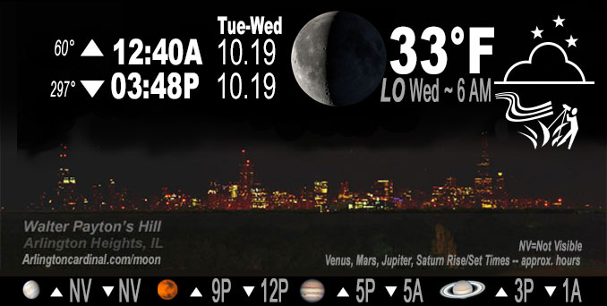
🌘 🌑 🌗 🌕 Waning Crescent Moon, sky cover overnight Tue. to Wed., 96% to 24%, winds NW, 18 to 11 MPH, G26 to 23 MPH, Low 33, 6a to 8a
NWS CHGO | NWS HRLY | /NWSchicago | 🌡
ARLINGTON HEIGHTS WEATHER
▴ forecast7 (Arl. Hts.) | RADAR | WIDE RADAR
IMPORTANT NOTE ON NWS DATA
======================
No Watches or Warnings overnight Tuesday to Wednesday.
Updates at Arlingtoncardinal.com/NWSChicago
======================
O’HARE FORECAST …
Forecast Beginning Tuesday Night, Oct. 18, 2022
Tuesday Night Mostly cloudy, with a low around 32. Breezy, with a northwest wind 15 to 20 mph, with gusts as high as 30 mph.
Wednesday Sunny, with a high near 48. West wind 10 to 15 mph, with gusts as high as 20 mph.
Wednesday Night Partly cloudy, with a low around 33. West wind 5 to 10 mph, with gusts as high as 20 mph.
Thursday Mostly sunny, with a high near 57. West southwest wind 10 to 15 mph, with gusts as high as 25 mph.
Thursday Night Mostly cloudy, with a low around 42. West northwest wind around 5 mph becoming south southwest after midnight.
Friday Mostly sunny, with a high near 70.
Friday Night Mostly clear, with a low around 50.
Saturday Sunny, with a high near 72.
Saturday Night Partly cloudy, with a low around 56.
Sunday Mostly sunny, with a high near 74.
Sunday Night A chance of showers. Mostly cloudy, with a low around 60.
Monday A chance of showers. Partly sunny, with a high near 72.
Monday Night A chance of showers. Mostly cloudy, with a low around 51.
Tuesday A chance of showers. Partly sunny, with a high near 64.
O’Hare forecast archive and hourly weather observations archive are available HERE on the CARDINAL NEWS Magazine.
Arlingtoncardinal.com/moonphases
Arlingtoncardinal.com/nightsky
NIGHT SKY THIS MONTH …
Check the night sky objects for this month and past months in the playlist from the Space Telescope Science Institute YouTube channel Backyard stargazers get a monthly guide to the northern hemisphere’s skywatching events with “Tonight’s Sky” (Musical track The Far River written by Jonn Serrie, from the album And the Stars Go With You courtesy of New World Music Ltd. Musical track The Far River written by Jonn Serrie, from the album And the Stars Go With You courtesy of New World Music Ltd).
Telephoto lens, ISO 100, f/11, Shutter Speed 1/100 to 1/125 for the Moon.
Get updates from The Cardinal ALL NEWS FEEDS on Facebook. Just ‘LIKE’ the ‘Arlington Cardinal Page (become a fan of our page). The updates cover all posts and sub-category posts from The Cardinal — Arlingtoncardinal.com. You can also limit feeds to specific categories. See all of The Cardinal Facebook fan pages at Arlingtoncardinal.com/about/facebook …
Help fund The Cardinal Arlingtoncardinal.com/sponsor
Telephoto lens, ISO 1600, f/11, Shutter Speed 2.5″ for the skyline. The skyline exposure was toned down, and brightness and contrast was adjusted in Photoshop.
Area Forecast Discussion
National Weather Service Chicago/Romeoville, IL
327 PM CDT Tue Oct 18 2022
.SHORT TERM…
Issued at 327 PM CDT Tue Oct 18 2022
Through Wednesday night…
A cut-off and vertically stacked low pressure system centered over the vicinity of eastern Lake Huron and Georgian Bay continues to dominate the weather pattern across the Great Lakes and northeastern CONUS this afternoon with an expansive comma-shaped cloud shield spanning from the western Great Lakes to a few hundred miles off the Atlantic coast. While we find ourselves on the western terminus of this cloud shield, this low`s influence is still very much being felt in other ways in our CWA, predominantly in the form of blustery northwest winds resulting from the compact low-level pressure gradients between the low and a region of high pressure over the Great Plains. These winds — frequently gusting in excess of 30 mph — are expected to continue into this evening before slowly abating and becoming less frequent overnight. Prior to that occurring, the combination of these northwest winds and the high waves that they are causing may result in minor lakeshore flooding along the northwest Indiana shoreline.
Additionally, multiple bands of lake effect precipitation are evident along the eastern half of Lake Michigan on regional radar mosaics this afternoon. Lake effect parameters are not nearly as impressive as they were yesterday, but should remain sufficient to allow for this precipitation to continue for several more hours. Most of this precipitation will remain east of our CWA, but Porter County (and perhaps portions of neighboring Jasper and Lake counties) is positioned favorably to at least see intermittent light precipitation pass over portions of the county through this evening and possibly into the overnight hours as well. Thermodynamic profiles suggest that rain will be the favored precipitation type for the most part, but snowflakes could mix in or become the outright precipitation type as cooler temperatures set in tonight. Either way, not expecting any impacts with this given how light the precipitation will be.
Overnight temperatures will fall below freezing across most of the CWA tonight with only the innermost portions of the Chicago metro and portions of Lake and Porter counties in Indiana likely seeing low temperatures remain above the freezing mark. Wednesday will be another unseasonably cool day with highs expected to peak in the mid to upper 40s, for the most part, despite mostly sunny skies as the residing Canadian air mass remains more or less in place. Winds are not expected to be quite as blustery as they were today with the surface pressure gradient relaxing in response to the weakening of the aforementioned occluding surface low to our northeast. Low temperatures on Wednesday night then look to range from the mid 20s to the mid 30s.
Ogorek/NWS Chicago/NWS Chicago
