
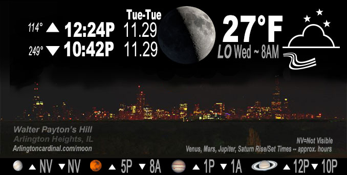
🌒 🌓 🌕 🌗 Waxing Crescent Moon, sky cover overnight Tue. to Wed. 86% to 43%, winds SW to WNW to W, 18 to 24 to 22 MPH, G31 to 38 to 36 MPH, Low 27, 8a to 9a
NWS CHGO | NWS HRLY | /NWSchicago | 🌡
ARLINGTON HEIGHTS WEATHER
▴ forecast7 (Arl. Hts.) | RADAR | WIDE RADAR
IMPORTANT NOTE ON NWS DATA
======================
Overnight Tuesday/Wednesday …
Weather Hazards expected…
This Weather Outlook is for portions of North Central Illinois…Northeast Illinois and Northwest Indiana.
Earlier Tuesday
Elevated Non Thunderstorm Wind Risk — wind forecast to start increasing over 20 MPH gust after 2:00 a.m. and increasing to 36 MPH or more between 12:00 p.m. and 2:00 p.m.
Limited Thunderstorm Risk (6:00 p.m. to 11:00 p.m.)…with an associated …
Limited damaging wind risk…up to 50 to 60 mph.
Later Tuesday
Occasional wind gusts to 40 mph will be possible overnight Tuesday/Wednesday.
DISCUSSION…
Earlier Tuesday
Patchy drizzle possible this morning, with scattered showers developing later this afternoon, and then peak shower coverage in a broken line ahead of the cold front this evening that could provide brief enhanced gusts of >50 mph
Low pressure of 993 mb over Kansas (near 3 standard deviations below normal for this time of year), which will hold its own on its northeast track today with the center traveling directly over northwest Illinois around Tuesday afternoon at 3:00 p.m., and be over northeast Wisconsin by 5:00 p.m.
Later Tuesday
Occasional wind gusts to 40 mph will be possible overnight Tuesday/Wednesday.
Temperatures and dew points are plunging in the wake of the cold front, with the 32 degree isotherm nearly into Winnebago/Lee/Ogle counties just after 9:00 p.m. Gusty winds and lack of more appreciable rainfall will mitigate a flash-freeze risk as temperatures drop into the 20s. Quite the airmass change to wake up to Wednesday morning, with wind chills to start the day in the single digits.
Hello mobile users! If you encounter mobile “unfriendly” weather page, turn your phone sideways for a better view.
======================
O’HARE FORECAST …
Forecast Beginning Tuesday Night, Nov. 29, 2022
Overnight Tuesday/Wednesday: Mostly cloudy, with a low around 26. Breezy, with a west wind around 25 mph, with gusts as high as 40 mph.
Wednesday: Mostly sunny, with a high near 33. Breezy, with a west wind around 25 mph, with gusts as high as 40 mph.
Wednesday Night: Mostly clear, with a low around 20. Breezy, with a west wind 15 to 20 mph decreasing to 10 to 15 mph after midnight. Winds could gust as high as 35 mph.
Thursday: Sunny, with a high near 37. West wind 10 to 15 mph becoming south in the afternoon. Winds could gust as high as 25 mph.
Thursday Night: Partly cloudy, with a low around 31. South wind around 15 mph, with gusts as high as 25 mph.
Friday: Mostly cloudy, with a high near 47. Breezy.
Friday Night: A 20 percent chance of rain before midnight. Mostly cloudy, with a low around 34. Breezy.
Saturday: Sunny, with a high near 36. Breezy.
Saturday Night: Partly cloudy, with a low around 22.
Sunday: A chance of rain and snow after noon. Partly sunny, with a high near 40.
Sunday Night: A chance of rain and snow. Mostly cloudy, with a low around 31.
Monday: A chance of rain. Mostly cloudy, with a high near 44.
Monday Night: A chance of rain. Mostly cloudy, with a low around 32.
Tuesday: A chance of rain and snow. Mostly cloudy, with a high near 40.
O’Hare forecast archive and hourly weather observations archive are available HERE on the CARDINAL NEWS Magazine.
Arlingtoncardinal.com/moonphases
Arlingtoncardinal.com/nightsky
NIGHT SKY THIS MONTH …
Check the night sky objects for this month and past months in the playlist from the Space Telescope Science Institute YouTube channel Backyard stargazers get a monthly guide to the northern hemisphere’s skywatching events with “Tonight’s Sky” (Musical track The Far River written by Jonn Serrie, from the album And the Stars Go With You courtesy of New World Music Ltd. Musical track The Far River written by Jonn Serrie, from the album And the Stars Go With You courtesy of New World Music Ltd).
Telephoto lens, ISO 100, f/11, Shutter Speed 1/100 to 1/125 for the Moon.
Get updates from The Cardinal ALL NEWS FEEDS on Facebook. Just ‘LIKE’ the ‘Arlington Cardinal Page (become a fan of our page). The updates cover all posts and sub-category posts from The Cardinal — Arlingtoncardinal.com. You can also limit feeds to specific categories. See all of The Cardinal Facebook fan pages at Arlingtoncardinal.com/about/facebook …
Help fund The Cardinal Arlingtoncardinal.com/sponsor
Telephoto lens, ISO 1600, f/11, Shutter Speed 2.5″ for the skyline. The skyline exposure was toned down, and brightness and contrast was adjusted in Photoshop.
Area Forecast Discussion
National Weather Service Chicago/Romeoville, IL
1025 PM CST Tue Nov 29 2022
.UPDATE… Issued at 919 PM CST Tue Nov 29 2022
Quick update to clear PoPs out of our area by 10 PM based on radar trends. Have also cleared the Illinois counties from the wind advisory with stronger gusts looking pretty intermittent and localized. A core of stronger winds will move in aloft through the rest of the night, but the ceiling on widespread gusts looks to be around 40 mph or so. Can`t rule out a few ephemeral higher gusts as an impressive area of pressure rises pushes across the region overnight.
Temperatures and dewpoints are plunging in the wake of the front, with the 32 degree isotherm nearly into Winnebago/Lee/Ogle counties. Gusty winds and lack of more appreciable rainfall will mitigate an flash-freeze risk as temperatures drop into the 20s. Quite the airmass change to wake up to tomorrow, with wind chills to start the day in the single digits.
Carlaw
&&
.SHORT TERM… Issued at 241 PM CST Tue Nov 29 2022
Through Wednesday night…
Through the early afternoon, winds have been moving pretty good across the area, though they`re not quite as strong as expected. It appears that we weren`t able to mix into much of the 40-45 kt winds found not far off the surface, which is a little surprising simply due to the several hours of sunshine that we saw earlier today which would normally promote deeper mixing. However, given such a tight vertical wind gradient, we knew that any subtle changes in mixing would lead to notable changes in winds at the surface. Nonetheless, it`s a breezy day out there with regular gusts across the area of 30- 35 mph. Winds are expected to subside a bit from the mid-afternoon through the early evening with low level warm air advection ahead of the approaching cold front limiting our mixing layer depth even further. Now in the heart of the storm`s warm sector, mostly skies have filled back in as the low levels continue to saturate.
As of 2:00 this afternoon, the center of the low sits in eastern Iowa with the cold front dragging behind as it continues its quick trek to the NNE. So far, the CWA has managed to stay dry with the exception of a narrow line a showers moving through parts of northwest Indiana. Scattered showers are expected to develop a little later this afternoon and persist into the evening leading up to the arrival of the front. The front is expected to arrive in the western CWA near 6:00 this evening and propagate eastward through the majority of the evening before departing the area roughly between 11:00 and midnight. Along the boundary is expected to be a line of showers with frontal forcing transporting moisture up to around 700mb. Some shallow convective showers or a couple of low-topped thunderstorms remain very possible as well for areas south and east of I-55. The favorability for convection along the front appears to be on a downward trend, but a very gradual one at that. The RAP, which has been the most excited in regards to instability, presents upwards of around 300 J/kg of MUCAPE in the far eastern and southeastern CWA just ahead of and along the boundary, down from near 500 J/kg with this morning`s runs. The low level wind profile, while still impressive, has lost a bit of its oomph as well. However, we`re still looking at around 35 kt of 0-1 km shear, down about 10 kt from yesterday, with nearly 300 m2/s2 of 0-1 km SRH. This shear profile is driving the possibility of strong to severe winds or even a brief, weak tornado which is marginal at best but certainly non-zero. This potential for strong to potentially severe storms also appears confined to areas east of I-55, although the main area of focus is northwest Indiana where greater instability and moisture is expected ahead of the front. Should strong to severe storms come to fruition, we`re probably looking at winds near 60 mph which will be enough to down small tree limbs and sizable branches as well as blow around lighter outdoor furniture and holiday decorations. The line of showers along the front should be the last of rain for the night with rapid pressure rises behind the front making it difficult for post-frontal precip to develop, perhaps with the exception of a couple of flurries as we manage to hang onto a fair deal of low level moisture.
In addition to the strong winds in the vicinity of the front, a tightening pressure gradient will ramp winds up again in the evening on either side of the front. This is especially true on the backside of the surface trough as the cold air advection should allow us to begin mixing again into the lowest 100 mb or so. While flow through this layer won`t be quite as robust as earlier today, we could possibly mix down 30 to near 40 kt winds into the overnight. Similarly breezy conditions can be expected through the day on Wednesday as well as the gradient flow remains strong and we continue to mix into a decent LLJ overhead. The strong flow behind the system will waste no time in dragging a frigid airmass into the Midwest and really cooling things off for Wednesday. Wednesday morning lows are forecast in the lower and middle 20`s followed by highs right around freezing despite mostly sunny skies. The winds will keep wind chills down in the teens to near 20 degrees through the day. Temperatures in the teens and wind chills in the single digits await us Wednesday night and early Thursday morning.
Doom/NWS Chicago
