
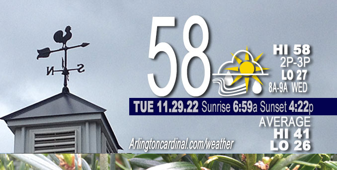
TUESDAY Hi 58, mostly cloudy, light rain 5p to 11p, winds SE to S to SSW to WNW, 17 to 24 to 22 MPH, G30 to 41 to 34 MPH, continuing Wednesday
NWS CHGO | NWS HRLY | /NWSchicago | 🌡
ARLINGTON HEIGHTS WEATHER
▴ forecast7 (Arl. Hts.) | RADAR | WIDE RADAR
⏪ Hrly Data Table | Hrly Future Graph ⏩
IMPORTANT NOTE ON NWS DATA
⏪ Hrly Data Table | Hrly Future Graph ⏩
======================
Tuesday and Tuesday Night …
Weather Hazards expected…
Elevated Non Thunderstorm Wind Risk.
Limited Thunderstorm Risk…with an associated …
Limited damaging wind risk…up to 50 to 60 mph.
DISCUSSION…
South winds will gust to 35 to 45 mph Tuesday, with the highest gusts expected south of I-80 late this morning into early afternoon.
During this evening, gusty showers and possibly a couple thunderstorms are expected to move eastward in a broken line. A few of these showers could produce gusts over 50 mph, capable of downing tree branches.
West winds will gusts to 35 to 40 mph overnight.
A strong low-level jet, and a deepening and faster-moving surface low will present a quick ramp up in impressive pressure falls of about 5 mb/3-hr and 10 mb/6-hr toward mid day through early-mid afternoon. Isallobaric pressure falls are an important factor in tapping into higher momentum aloft in these tricky warm advection setups. Expectation is that there will be a sufficient timeframe of scattering of clouds and/or high enough cloud bases to tap into the low level jet for frequent gusts to around 45 mph for a 3-5 hour window for locations in and near the Wind Advisory, which is in effect Tuesday morning in an area approximately south of I-55.
Hello mobile users! If you encounter mobile “unfriendly” weather page, turn your phone sideways for a better view.
======================
O’HARE FORECAST …
Forecast Beginning Tuesday, Nov. 29, 2022
Tuesday: A 30 percent chance of showers, mainly after 5pm. Mostly cloudy, with a high near 58. Breezy, with a south southeast wind 15 to 25 mph, with gusts as high as 40 mph.
Tuesday Night: Showers likely, mainly before 9pm. Cloudy, then gradually becoming partly cloudy, with a low around 27. Breezy, with a south wind 20 to 25 mph becoming west after midnight. Winds could gust as high as 40 mph. Chance of precipitation is 70%. New precipitation amounts between a tenth and quarter of an inch possible.
Wednesday: Mostly sunny, with a high near 33. Breezy, with a west wind 20 to 25 mph, with gusts as high as 40 mph.
Wednesday Night: Mostly clear, with a low around 20. Breezy, with a west wind 15 to 20 mph decreasing to 10 to 15 mph after midnight. Winds could gust as high as 35 mph.
Thursday: Sunny, with a high near 36. West wind 10 to 15 mph becoming south in the afternoon.
Thursday Night: Partly cloudy, with a low around 30.
Friday: Mostly cloudy, with a high near 51. Breezy.
Friday Night: Mostly cloudy, with a low around 35.
Saturday: Mostly sunny, with a high near 39. Breezy.
Saturday Night: Partly cloudy, with a low around 24.
Sunday: A chance of rain and snow. Partly sunny, with a high near 40.
Sunday Night: A chance of rain and snow. Mostly cloudy, with a low around 33.
Monday: A chance of rain and snow. Mostly cloudy, with a high near 42.


CHICAGOWEATHERSTATION.COM

ChicagoWeatherStation.com I O’Hare Normal Temps/Precip I O’Hare Record Temps, Precip, Snow
LIVE RADAR | STORM TRACKS | UNISYS US IR SAT | UNISYS Midwest IR SAT | UNISYS More IR SAT
WunderMap® with Temperature/Wind Data || Google: Arlington Heights Area Temps | US TEMPS
Full Screen Motion Weather Radar (Wunderground.com)
Midwest Cloud Cover with Arlington Heights Weather Forecast
ChicagoWeatherStation.com I O’Hare Normal Temps/Precip I O’Hare Record Temps, Precip, Snow
SUNLIGHT DATA FOR SECURITY, TRAFFIC SAFETY, AND SPORTS
SunCalc.net data with solar azimuth and trajectory, times for dawn, sunrise, solar noon, sunset, dusk …
NIGHT SKY THIS MONTH …
Backyard stargazers get a monthly guide to the northern hemisphere’s skywatching events with “Tonight’s Sky.” Check the night sky objects for this month and past months in the playlist from the Space Telescope Science Institute YouTube channel (Musical track The Far River written by Jonn Serrie, from the album And the Stars Go With You courtesy of New World Music Ltd).
Get updates from The Cardinal ALL NEWS FEEDS on Facebook. Just ‘LIKE’ the ‘Arlington Cardinal Page (become a fan of our page). The updates cover all posts and sub-category posts from The Cardinal — Arlingtoncardinal.com. You can also limit feeds to specific categories. See all of The Cardinal Facebook fan pages at Arlingtoncardinal.com/about/facebook …
Help fund The Cardinal Arlingtoncardinal.com/sponsor
Area Forecast Discussion
National Weather Service Chicago/Romeoville, IL
549 AM CST Tue Nov 29 2022
.SHORT TERM… Issued at 333 AM CST Tue Nov 29 2022
Through Wednesday Night…
The main weather points for the new two days are:
* Windy period of 35 to 45 mph gusts, with the upper end most likely to be realized south of I-80 late morning through early afternoon today where a Wind Advisory has been issued
* Patchy drizzle possible this morning, with scattered showers developing later this afternoon, and then peak shower coverage in a broken line ahead of the cold front this evening that could provide brief enhanced gusts of >50 mph
* Roller coaster of temperatures with 55F to near 60F for much of the area this afternoon into early evening before a crash that will provide wind chills Wednesday morning of 8F to 15F
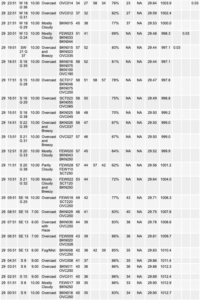
This morning`s surface analysis places low pressure of 993 mb over Kansas (near 3 standard deviations below normal for this time of year), which will hold its own on its northeast track today. This is being scooted along by a quick-moving neutrally tilted upper trough. The CWA will progressively become in more of a warm sector as the low lifts to our latitude by early afternoon in eastern Iowa, which is a quicker solution in guidance than seen yesterday. Within the warm sector this time of year, low clouds are often common and there are areas of them early this morning. Patchy drizzle may develop as well, although anything should be light. While some haze/light fog is probable too, it`s unlikely to become dense due to increasing southerly flow and the lack of a markedly cold ground.
* Strong South Winds Today:
There are multiple competing factors at play today with respect to the magnitude of southerly wind gusts and their duration. The synoptic setup of a strong warm advection regime in the warm sector of a deepening surface low is always challenging in terms of mixing heights, given propensity in the cool season for low stratus streaming northward, and this will certainly be an issue today. The mixing heights are of paramount importance, as low level jet will actually peak during the day and feature 40-50 kt flow in the 1-2kft AGL layer.
On the favorable side, along with the strength of the low-level jet, deepening and faster moving surface low will present a quick ramp up in impressive pressure falls of about 5 mb/3-hr and 10 mb/6-hr toward mid day through early-mid afternoon. Isallobaric pressure falls are an important factor in tapping into higher momentum aloft in these tricky warm advection setups. Expectation is that there will be a sufficient timeframe of scattering of clouds and/or high enough cloud bases to tap into the low level jet for frequent gusts to around 45 mph for a 3-5 hour window for locations in and near the Wind Advisory. This lines of nicely with 00z HREF mean (and max) wind gusts, as well as HREF probabilities of 45+ mph gusts.
Shorter duration of favorable mixing depths and/or likelihood of low clouds being too much of an impediment (especially farther north and west) precluded including more of the CWA in the advisory. Will include a SPS for a portion of the area north of the advisory counties to message potential for frequent 40 mph gusts and brief period up to 45 mph, likely including Chicago.
* Temperatures Today:
The southerly winds today will drive warm air advection with 925 mb temperatures reaching 9C to 11C this afternoon into early evening. While some breaks of sun are expected along and east of I-55, these should be short-lived, so the magnitude of temperatures reached will depend fully on advection. Some places in the northern CWA may be slow to climb this morning under more persistent low clouds but everywhere is probable to reach 55 and 60 will probably poke into the forecast area as well.
* Gusty Shower Potential This Evening:
The pre-cold frontal air mass will have ample low-level moisture (dew points in the lower to mid 50s) for showers to peak in coverage during the early to mid evening. Most convection allowing models (CAMs) support a strongly forced broken line of convective showers ahead of the front moving across the CWA between 6 and 10 P.M. These showers along the front are expected to have a narrow ribbon of low-level instability to work with. Most guidance indicates this to be weak (<50-75 J/kg) due to moist adiabatic lapse rates in the lower troposphere. Also, this positive CAPE profile looks unlikely to provide equilibrium levels above -10C for charge separation, so lightning if it occurs should be very spotty. That all said, the synoptic setup of a sub-1000 mb low deepening on a path from eastern Iowa to Wisconsin bears some watching for a conceptual setups of a few gusts to near severe limits if shower downdrafts in a more solid line materialize right on the front. What is likely hindering a severe weather setup further north is the greater moisture mass response is over the Lower Mississippi and Lower Ohio valleys. Also that convection in turn will likely rob some moisture transport for a broader footprint of rain/convection this evening in our area. * Late Tonight and Wednesday: Behind the cold front late this evening, winds will abruptly turn westerly and sharply re-increase in speed within stout cold advection. Gusts of 35 to 40 mph look to be fairly homogeneous in both space and time within the cold advection regime overnight all the way through much of Wednesday, though a few gusts to 45 mph are possible right behind the front. The quicker progression of the surface low results in the forecast area not ideally lining up the maximum pressure rises and cold advection after sunrise, and thus less likely a Wind Advisory will be needed for Wednesday at this time. The 925 mb temperatures will basically flip their sign from late this afternoon to Wednesday morning, falling from 9 to 11C to -9 to -11C. Surface temperatures will have dropped into the mid to upper 20s by morning with wind chills largely in the lower to mid teens. Some stratocumulus is expected north of I-80 and could have spotty "low quality" flurries toward the Wisconsin state line given the cloud layer, while thin, being within -12C to -15C. Surface temperatures should only rise a few degrees during Wednesday. Ridging will move back over the area by daybreak Thursday, which with clear skies has forecast lows of 15 to 20. MTF/Castro/NWS Chicago
