
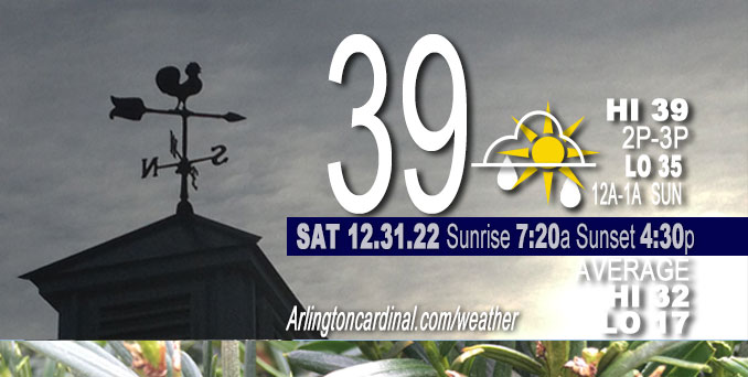
Saturday Hi 39, partly sunny, rain, 9p to 5a, winds SSW to SE, 2 to 5 to 7 MPH
NWS CHGO | NWS HRLY | /NWSchicago | 🌡
ARLINGTON HEIGHTS WEATHER
▴ forecast7 (Arl. Hts.) | RADAR | WIDE RADAR
⏪ Hrly Data Table | Hrly Future Graph ⏩
IMPORTANT NOTE ON NWS DATA
⏪ Hrly Data Table | Hrly Future Graph ⏩
======================
Saturday and Saturday Night …
No Weather Hazards expected…
Chance for mixed rain and snow then rain this evening and overnight.
DISCUSSION…
Around 5:30 a.m. Saturday there was a 10-15 degree temperature gradient across the area with lower 20s up toward Rockford and low to mid 30s into portions of northwest Indiana. Warmer New Years Day Sunday with a high of 45°F. Monday high 48°F, Tuesday high 57°F
Hello mobile users! If you encounter a mobile “unfriendly” weather page, turn your phone sideways for a better view.
======================
O’HARE FORECAST …
Forecast Beginning Saturday, Dec. 31, 2022
Saturday: Mostly cloudy, with a high near 39. Calm wind becoming south around 5 mph in the afternoon.
Saturday Night: A slight chance of rain before 8pm, then a chance of rain and snow between 8pm and 10pm, then a chance of rain after 10pm. Cloudy, with a low around 34. South southeast wind around 5 mph. Chance of precipitation is 50%.
New Year’s Day: Mostly cloudy, with a high near 46. West wind around 5 mph.
Sunday Night: Cloudy, with a low around 35. West wind around 5 mph becoming calm in the evening.
Monday: A 30 percent chance of rain, mainly after 3pm. Cloudy, with a high near 48. East wind 5 to 10 mph.
Monday Night: Rain, with thunderstorms also possible after 9pm. Low around 43. Chance of precipitation is 100%.
Tuesday: A 40 percent chance of rain, mainly before noon. Mostly cloudy, with a high near 57. Breezy.
Tuesday Night: Mostly cloudy, with a low around 33. Breezy.
Wednesday: Mostly cloudy, with a high near 37.
Wednesday Night: Mostly cloudy, with a low around 27.
Thursday: Mostly cloudy, with a high near 31.
Thursday Night: Partly cloudy, with a low around 23.
Friday: Mostly sunny, with a high near 35.


CHICAGOWEATHERSTATION.COM

ChicagoWeatherStation.com I O’Hare Normal Temps/Precip I O’Hare Record Temps, Precip, Snow
LIVE RADAR | STORM TRACKS | UNISYS US IR SAT | UNISYS Midwest IR SAT | UNISYS More IR SAT
WunderMap® with Temperature/Wind Data || Google: Arlington Heights Area Temps | US TEMPS
Full Screen Motion Weather Radar (Wunderground.com)
Midwest Cloud Cover with Arlington Heights Weather Forecast
ChicagoWeatherStation.com I O’Hare Normal Temps/Precip I O’Hare Record Temps, Precip, Snow
SUNLIGHT DATA FOR SECURITY, TRAFFIC SAFETY, AND SPORTS
SunCalc.net data with solar azimuth and trajectory, times for dawn, sunrise, solar noon, sunset, dusk …
NIGHT SKY THIS MONTH …
Backyard stargazers get a monthly guide to the northern hemisphere’s skywatching events with “Tonight’s Sky.” Check the night sky objects for this month and past months in the playlist from the Space Telescope Science Institute YouTube channel (Musical track The Far River written by Jonn Serrie, from the album And the Stars Go With You courtesy of New World Music Ltd).
Get updates from The Cardinal ALL NEWS FEEDS on Facebook. Just ‘LIKE’ the ‘Arlington Cardinal Page (become a fan of our page). The updates cover all posts and sub-category posts from The Cardinal — Arlingtoncardinal.com. You can also limit feeds to specific categories. See all of The Cardinal Facebook fan pages at Arlingtoncardinal.com/about/facebook …
Help fund The Cardinal Arlingtoncardinal.com/sponsor
Area Forecast Discussion
National Weather Service Chicago/Romeoville, IL
1150 AM CST Sat Dec 31 2022
.SHORT TERM… Issued at 320 AM CST Sat Dec 31 2022
Through Sunday…
Key Messages:
* Chance for precipitation this evening and overnight.
– Most areas along/south of I-88 see only rain
– May initially mix with snow shortly after onset NW of Chicago toward the WI/IL state line where a slushy coating of snow is possible.
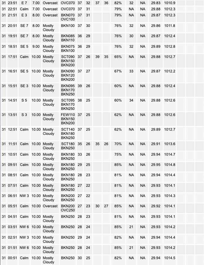
All is quiet to start the final day of the calendar year across Chicagoland. Currently have a 10-15 degree temperature gradient across the area with lower 20s up toward Rockford and low to mid 30s into portions of northwest Indiana. Thin cirrus clouds overhead seem to have limited our fog risk thus far, though a few patchy areas of fog remain possible through sunrise. The surface ridge axis will move across the area today, with light northwest winds becoming variable for a time then turning southerly. Temperatures today are forecast to warm into the upper 30s to lower 40s.
A low amplitude shortwave moving across the Upper Midwest today combined with some support for lift beneath the left exit of the upper jet will bring a chance for precipitation to the area after sunset through the evening and into the early overnight hours of the new year. Latest trend has been slightly higher QPF with this system and an expansion further south. There still remains some uncertainty with how far south the coverage extends as well as whether snow is able to mix in the first few hours after the onset in areas mainly along/north of I-88. Snowfall potential will be contingent upon sufficient evaporative cooling to a sub- freezing wet-bulb temperature given an initially stout warm 900-850 mb layer. This could result in a few hour period where snow is possible before wet-bulb temperatures return to above freezing. In fact, a slushy coating of snow wouldn`t be surprising up toward the WI/IL stateline. Have left a slight chance mention for some freezing rain in rural spots northwest of the Chicago metro to account for if temperatures briefly dip below freezing early in the evening.
In the wake of this system there is a signal again for some fog development late Sunday night into the morning as warm moist air continues to advect north into the region. Have left this out of the gridded forecast for now due to it being over 24 hours and model guidance has been too aggressive with low stratus and fog the past few days. Nevertheless, this may need to be considered with later updates given a more favorable setup than the past few days. Even with some lingering fog/low stratus, think the warm advection should be enough to warm temperatures into the 40s across the area by mid afternoon, though it may be slow to warm initially during the morning hours.
Petr/NWS Chicago
