
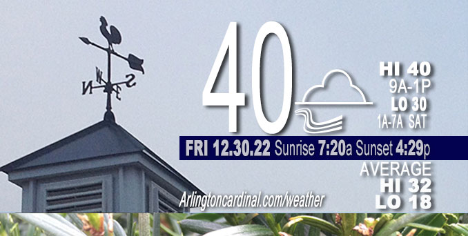
Friday Hi 40, mostly cloudy, winds WNW to NW, 11 to 5 to 6 MPH, G18 to 13 MPH ending 12p
NWS CHGO | NWS HRLY | /NWSchicago | 🌡
ARLINGTON HEIGHTS WEATHER
▴ forecast7 (Arl. Hts.) | RADAR | WIDE RADAR
⏪ Hrly Data Table | Hrly Future Graph ⏩
IMPORTANT NOTE ON NWS DATA
⏪ Hrly Data Table | Hrly Future Graph ⏩
======================
Friday and Friday Night …
No Weather Hazards expected…
Temperatures will be steady, then drop through the day today behind a cold front … especially after 1:00 p.m.
DISCUSSION…
The breezy south to southwest winds with the smell of Spring air have been replaced by weakening winds from the west-northwest. Overnight, a few lightning strikes reached as far north as central Illinois, just west of Champaign. The week of New Year’s Day is looking mild for the middle of Winter with a high 45°F on New Year’s Day, a high of 47°F on Monday, and a high near 55°F on Tuesday.
Hello mobile users! If you encounter a mobile “unfriendly” weather page, turn your phone sideways for a better view.
======================
O’HARE FORECAST …
Forecast Beginning Friday, Dec. 30, 2022
Friday: Cloudy, with a steady temperature around 38. West wind 5 to 10 mph, with gusts as high as 15 mph.
Friday Night: Mostly cloudy, with a low around 30. Northwest wind around 5 mph.
Saturday: Partly sunny, with a high near 39. North wind around 5 mph becoming south southeast in the afternoon.
Saturday Night: A 20 percent chance of rain after 9pm. Mostly cloudy, with a low around 32. South wind 5 to 10 mph, with gusts as high as 15 mph.
New Year’s Day: Mostly cloudy, with a high near 45. Southwest wind 5 to 10 mph, with gusts as high as 15 mph.
Sunday Night: Mostly cloudy, with a low around 35.
Monday: A 40 percent chance of rain after noon. Cloudy, with a high near 47.
Monday Night: Rain. Cloudy, with a low around 42.
Tuesday: A chance of rain. Partly sunny, with a high near 55.
Tuesday Night: Mostly cloudy, with a low around 33.
Wednesday: Mostly cloudy, with a high near 37.
Wednesday Night: Mostly cloudy, with a low around 27.
Thursday: Mostly cloudy, with a high near 31.


CHICAGOWEATHERSTATION.COM

ChicagoWeatherStation.com I O’Hare Normal Temps/Precip I O’Hare Record Temps, Precip, Snow
LIVE RADAR | STORM TRACKS | UNISYS US IR SAT | UNISYS Midwest IR SAT | UNISYS More IR SAT
WunderMap® with Temperature/Wind Data || Google: Arlington Heights Area Temps | US TEMPS
Full Screen Motion Weather Radar (Wunderground.com)
Midwest Cloud Cover with Arlington Heights Weather Forecast
ChicagoWeatherStation.com I O’Hare Normal Temps/Precip I O’Hare Record Temps, Precip, Snow
SUNLIGHT DATA FOR SECURITY, TRAFFIC SAFETY, AND SPORTS
SunCalc.net data with solar azimuth and trajectory, times for dawn, sunrise, solar noon, sunset, dusk …
NIGHT SKY THIS MONTH …
Backyard stargazers get a monthly guide to the northern hemisphere’s skywatching events with “Tonight’s Sky.” Check the night sky objects for this month and past months in the playlist from the Space Telescope Science Institute YouTube channel (Musical track The Far River written by Jonn Serrie, from the album And the Stars Go With You courtesy of New World Music Ltd).
Get updates from The Cardinal ALL NEWS FEEDS on Facebook. Just ‘LIKE’ the ‘Arlington Cardinal Page (become a fan of our page). The updates cover all posts and sub-category posts from The Cardinal — Arlingtoncardinal.com. You can also limit feeds to specific categories. See all of The Cardinal Facebook fan pages at Arlingtoncardinal.com/about/facebook …
Help fund The Cardinal Arlingtoncardinal.com/sponsor
Area Forecast Discussion
National Weather Service Chicago/Romeoville, IL
531 AM CST Fri Dec 30 2022
.SHORT TERM… Issued at 245 AM CST Fri Dec 30 2022
Through Saturday…
Key Messages:
* Scattered showers to continue along/SE of I-55 early this AM (a lightning strike or two possible)
* Showers persist at times through this evening S/SE of I-80/I-57
* Temperatures dropping through the day today behind cold front
Very warm temperatures continue early this morning in the 50s across the area. Moisture pooling ahead of the front also has dewpoints in the upper 50s in our southwest, as high as 58F observed at Pontiac, IL. This warm and moist airmass ahead of the front combined with synoptic support for lift beneath the southeast side of a strong upper jet, has set the stage for scattered shower development along and southeast of the Interstate-55 corridor. Though delayed by an hour or two, showers have begun to increase in coverage at this hour. A few lightning strikes have reached as far north as central Illinois (just west of Champaign), thus have left a mention for isolated thunder for the next few hours to account for a lightning strike or two in any more robust showers. The areal coverage of showers will shift southeast with time early this morning with the front. The surface boundary eventually stalls out just southeast of the forecast area with additional showers lifting into northwest Indiana and east central Illinois above the front that will persist off and on through today and into the evening.
Temperatures will steadily fall the rest of the day from northwest to southeast with most areas seeing their daily high temperatures early this morning. Expect a gradient in temperatures across the area, with generally 30s northwest of I-57 and 40s southeast. It will feel notably cooler tonight (typically upper teens to lower 20s) with lows dipping into the upper 20s to lower 30s tonight. Will note that if low stratus and possibly even some fog becomes more established tonight this would limit some of the overnight cooling. Surface high pressure then centers overhead on Saturday with light winds. It will still be cooler (relative to what we saw on Thursday) in the wake of today`s front combined with lingering cloud cover, with highs in the mid 30s to around 40.
Petr/NWS Chicago
