
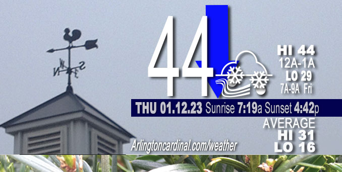
Thursday Hi 41, mostly cloudy, winds N to NNW, 14 to 17 to 15 MPH, G20 to 28 to 24 MPH
NWS CHGO | NWS HRLY | /NWSchicago | 🌡
ARLINGTON HEIGHTS WEATHER
▴ forecast7 (Arl. Hts.) | RADAR | WIDE RADAR
⏪ Hrly Data Table | Hrly Future Graph ⏩
IMPORTANT NOTE ON NWS DATA
⏪ Hrly Data Table | Hrly Future Graph ⏩
======================
Thursday and Thursday Night …
Weather Hazards expected …
Limited Snow Risk? (reconstructed)*
Limited Fog Risk? Fog southeast Chicagoland. (reconstructed)*
[*missed actual NWS notice, this is a CARDINAL NEWS estimate]
DISCUSSION…
Latest models limit measurable precipitation to largely south of the Illinois and Kankakee river valleys across the south/southeast parts of the Chicagoland forecast area Thursday. Thermal profiles across the southern Chicagoland support precipitation be in the form of rain through this afternoon.
======================
O’HARE FORECAST …
Forecast Beginning Thursday, Jan. 12, 2023
Thursday: A slight chance of rain before 3pm, then a chance of rain and snow. Cloudy, with a high near 39. North wind around 15 mph, with gusts as high as 30 mph. Chance of precipitation is 30%.
Thursday Night: Scattered snow showers, mainly before midnight. Cloudy, with a low around 29. North northwest wind around 15 mph, with gusts as high as 25 mph. Chance of precipitation is 30%.
Friday: A chance of flurries before noon. Mostly cloudy, with a high near 32. North northwest wind around 15 mph, with gusts as high as 25 mph.
Friday Night: Partly cloudy, with a low around 22. North northwest wind 10 to 15 mph becoming light west after midnight.
Saturday: Mostly sunny, with a high near 39.
Saturday Night: Mostly cloudy, with a low around 30.
Sunday: Mostly cloudy, with a high near 44.
Sunday Night: A chance of showers after midnight. Cloudy, with a low around 40.
M.L.King Day: Showers. Cloudy, with a high near 50.
Monday Night: Showers likely. Cloudy, with a low around 40.
Tuesday: Mostly cloudy, with a high near 44.
Tuesday Night: Mostly cloudy, with a low around 33.
Wednesday: A chance of rain. Mostly cloudy with a high near 41.


CHICAGOWEATHERSTATION.COM

ChicagoWeatherStation.com I O’Hare Normal Temps/Precip I O’Hare Record Temps, Precip, Snow
LIVE RADAR | STORM TRACKS | UNISYS US IR SAT | UNISYS Midwest IR SAT | UNISYS More IR SAT
WunderMap® with Temperature/Wind Data || Google: Arlington Heights Area Temps | US TEMPS
Full Screen Motion Weather Radar (Wunderground.com)
Midwest Cloud Cover with Arlington Heights Weather Forecast
ChicagoWeatherStation.com I O’Hare Normal Temps/Precip I O’Hare Record Temps, Precip, Snow
SUNLIGHT DATA FOR SECURITY, TRAFFIC SAFETY, AND SPORTS
SunCalc.net data with solar azimuth and trajectory, times for dawn, sunrise, solar noon, sunset, dusk …
NIGHT SKY THIS MONTH …
Backyard stargazers get a monthly guide to the northern hemisphere’s skywatching events with “Tonight’s Sky.” Check the night sky objects for this month and past months in the playlist from the Space Telescope Science Institute YouTube channel (Musical track The Far River written by Jonn Serrie, from the album And the Stars Go With You courtesy of New World Music Ltd).
Get updates from The Cardinal ALL NEWS FEEDS on Facebook. Just ‘LIKE’ the ‘Arlington Cardinal Page (become a fan of our page). The updates cover all posts and sub-category posts from The Cardinal — Arlingtoncardinal.com. You can also limit feeds to specific categories. See all of The Cardinal Facebook fan pages at Arlingtoncardinal.com/about/facebook …
Help fund The Cardinal Arlingtoncardinal.com/sponsor
Area Forecast Discussion
National Weather Service Chicago/Romeoville, IL
619 AM CST Thu Jan 12 2023
.SHORT TERM… Issued at 311 AM CST Thu Jan 12 2023
Through Friday…
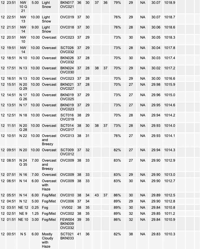
Surface low pressure was analyzed along the Arkansas/Missouri border early this morning, associated with a mid-level short wave trough (upper low) tracking east across eastern Kansas and Oklahoma. Guidance continues to trend toward a farther south and weaker mid- level feature over the next 24 hours, further delaying phasing with developing northern stream trough across the region. The result is a less-defined deformation precipitation shield, and a further shift south of the primary QPF axis away from the WFO LOT forecast area. Latest models limit measurable precipitation to largely south of the Illinois and Kankakee river valleys across the south/southeast parts of the forecast area today. Thermal profiles across the southern cwa support this to all be in the form of rain through this afternoon.
As the northern stream upper trough deepens across the upper Midwest and Great Lakes region today, guidance continues to depict a fairly healthy mid-level vort/trough will wrap southward across the region late today and tonight. Combined with increasing low level cold advection on blustery northerly winds, steepening low level lapse rates and increasing moisture depth looks to become increasingly supportive of rain/snow showers across the area by this evening. These should trend toward mainly snow showers during the overnight hours as the low level thermal profiles continue to cool. This also support a period of lake-induced/enhanced rain/snow showers downwind of Lake Michigan across northwest Indiana tonight into Friday, with some accumulations of 1-2 inches of wet snow possible. West of the lake, scattered flurries may linger across northern Illinois during the day Friday.
Temperatures will become steady in the mid-30s or slowly fall into that range as north winds increase and become blustery (in the south/southeastern cwa). Highs in the low-mid 30s Friday will actually be at or even slightly above our normals for mid-January, though blustery north winds to 25 mph (30 mph off the lake into northwest Indiana) will make feel chillier, with wind chills only in the low 20s for much of the day.
One last item is that there is some very patchy dense fog in a few spots early this morning, mainly across our far southeastern cwa. With our previously light/variable winds in the process of becoming north and increasing, dense fog is not expected to linger in any one place very long. Had issued an SPS for the southern counties earlier in the night and will refresh that to cover the next few hours before visibilities improve more solidly.
Ratzer/NWS Chicago
