
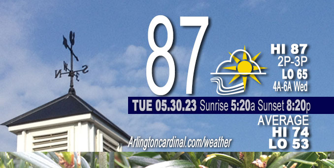
Tuesday Hi 87, partly cloudy, winds ESE to E to SE, 5 to 9 to 5 MPH, G14 MPH, 3p to 6p
NWS CHGO | NWS HRLY | /NWSchicago | 🌡
ARLINGTON HEIGHTS WEATHER
▴ forecast7 (Arl. Hts.) | RADAR | WIDE RADAR
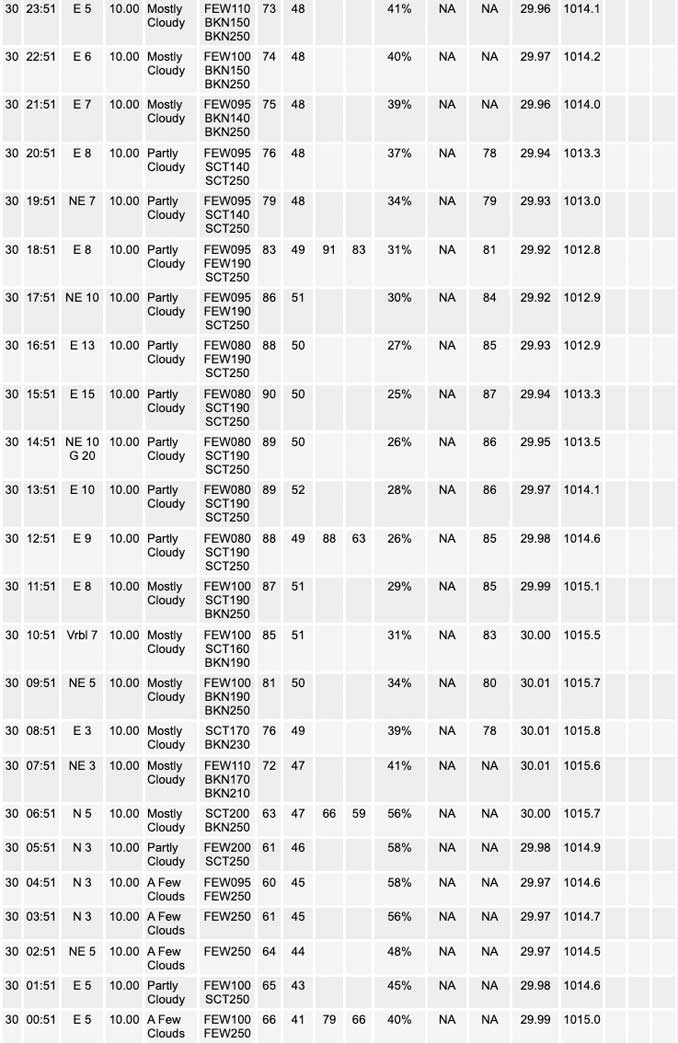
⏪ Hrly Data Table | Hrly Future Graph ⏩
IMPORTANT NOTE ON NWS DATA
⏪ Hrly Data Table | Hrly Future Graph ⏩
Hello mobile users! If you encounter a mobile “unfriendly” weather page, turn your phone sideways for a better view.
======================
Tuesday and Tuesday Evening …
No Weather Hazards …
Mostly sunny, with a high near 82. Temperatures ranging 74°F to 80°F during parade time. East northeast wind 5 to 10 mph, with gusts as high as 15 mph.
DISCUSSION…
Only forecast concern is the dewpoints, which continue to be lower than guidance forecast. Dewpoints mixed out Sunday afternoon allowing relative humidity levels do dip into the middle teen percent range across many areas. Winds are not a concern Monday or Tuesday. Thus, not planning any elevated fire danger mention.
======================
O’HARE FORECAST …
Forecast Beginning Tuesday, May 30, 2023
Tuesday: Sunny, with a high near 84. Light northeast wind becoming east 5 to 10 mph in the morning.
Tuesday Night: Mostly clear, with a low around 64. East wind 5 to 10 mph becoming light southeast after midnight.
Wednesday: A slight chance of showers between 1pm and 4pm, then a slight chance of showers and thunderstorms after 4pm. Mostly sunny, with a high near 86. Chance of precipitation is 20%.
Wednesday Night: A slight chance of thunderstorms before 7pm. Partly cloudy, with a low around 66. Chance of precipitation is 10%.
Thursday: Sunny, with a high near 87.
Thursday Night: Mostly clear, with a low around 65.
Friday: Sunny, with a high near 87.
Friday Night: Mostly clear, with a low around 62.
Saturday: Mostly sunny, with a high near 83.
Saturday Night: Mostly clear, with a low around 61.
Sunday: Sunny, with a high near 84.


CHICAGOWEATHERSTATION.COM

ChicagoWeatherStation.com I O’Hare Normal Temps/Precip I O’Hare Record Temps, Precip, Snow
WunderMap® with Temperature/Wind Data || Google: Arlington Heights Area Temps | US TEMPS
Midwest Cloud Cover with Arlington Heights Weather Forecast
ChicagoWeatherStation.com I O’Hare Normal Temps/Precip I O’Hare Record Temps, Precip, Snow
SUNLIGHT DATA FOR SECURITY, TRAFFIC SAFETY, AND SPORTS
SunCalc.net data with solar azimuth and trajectory, times for dawn, sunrise, solar noon, sunset, dusk …
NIGHT SKY THIS MONTH …
Backyard stargazers get a monthly guide to the northern hemisphere’s skywatching events with “Tonight’s Sky.” Check the night sky objects for this month and past months in the playlist from the Space Telescope Science Institute YouTube channel (Musical track The Far River written by Jonn Serrie, from the album And the Stars Go With You courtesy of New World Music Ltd).
Get updates from The Cardinal ALL NEWS FEEDS on Facebook. Just ‘LIKE’ the ‘Arlington Cardinal Page (become a fan of our page). The updates cover all posts and sub-category posts from The Cardinal — Arlingtoncardinal.com. You can also limit feeds to specific categories. See all of The Cardinal Facebook fan pages at Arlingtoncardinal.com/about/facebook …
Help fund The Cardinal Arlingtoncardinal.com/sponsor
/////////////>
Area Forecast Discussion
National Weather Service Chicago/Romeoville, IL
629 AM CDT Tue May 30 2023
.SHORT TERM… Issued at 238 AM CDT Tue May 30 2023
Through Wednesday…
Very warm summerlike weather to persist through mid-week, with a gradual increase in low-level moisture which may lead to some isolated to scattered showers and thunderstorms across parts of the area especially Wednesday afternoon.
Rex block remains in place across the eastern CONUS per 00Z upper air analysis, though it is progged to drift very slowly east through Wednesday. Primary influence on our local weather will be our low level wind field turning more southeasterly with time, which will gradually advect increasing low level moisture from the Appalachians and Ohio Valley. Several models develop spotty diurnal convective precipitation across our eastern cwa this afternoon, though much of the available guidance appears to continue to over forecast surface dew points when compared to upstream obs. HRRR/EC/CMC appear to be performing better with this than other models, and have generally favored these solutions through the short term period. HRRR forecast soundings during peak heating this afternoon depict generally capped profiles across most of the cwa, with the exception of the IL/IN state line area where low-level moisture return may be just sufficient enough to weaken the cap enough and produce an isolated shower/thunderstorm or two. Lack of larger scale forcing and weak wind fields (lake breeze boundary would be the most likely convergent feature – though stronger capping looks to exist along the boundary to the northwest) lend fairly low confidence for convection actually initiating however, and although can`t rule out an isolated shower or storm developing late this afternoon/early evening have maintained a dry forecast at this time. Wednesday afternoon looks to have a better potential for isolated to scattered showers/storms, as continued low-level moisture advection results in weaker/no capping.
Low level thermal fields continue to support very warm summerlike temps for late May, both today and Wednesday despite somewhat more cloud cover. Highs away from Lake Michigan should reach the upper 80s to around 90 both days, with 70s along the lake shore thanks to onshore lake breezes. Wednesday will likely feel a little more humid with the increased low level moisture, though not oppressively so.
Ratzer/NWS Chicago
