
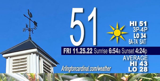
FRIDAY Hi 51, mostly sunny, winds W to SW, 9 to 10 to 8 MPH, G14 to 15 to 13 MPH, 8a to 4p
NWS CHGO | NWS HRLY | /NWSchicago | 🌡
ARLINGTON HEIGHTS WEATHER
▴ forecast7 (Arl. Hts.) | RADAR | WIDE RADAR
⏪ Hrly Data Table | Hrly Future Graph ⏩
IMPORTANT NOTE ON NWS DATA
⏪ Hrly Data Table | Hrly Future Graph ⏩
======================
Friday and Friday Night …
No Weather Hazards expected…
This Weather Outlook is for portions of North Central Illinois … Northeast Illinois and Northwest Indiana.
DISCUSSION…
Great late November weather will prevail Friday through the daytime hours Saturday with seasonally mild temperatures and plenty of sunshine.
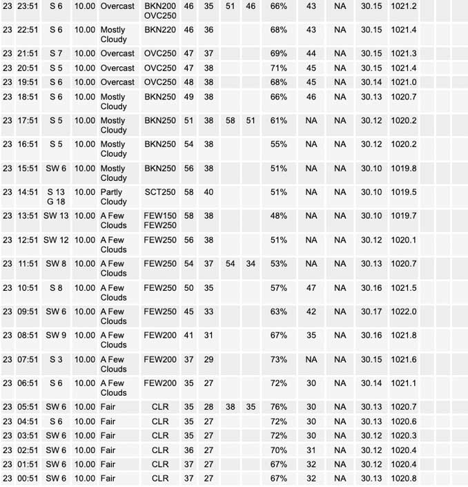
Drier air behind a cold front that passed through overnight will allow hazy conditions to erode and clouds to scour out this morning. Expect 20 mph gusts and wind chill experienced around sunrise to diminish. High temperatures should reach around 50 to 51 degrees Friday around 3:00 p.m.
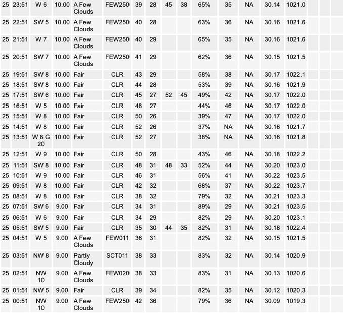
High pressure over southern Illinois will slide east across the Ohio and Tennessee valley Friday Night into Saturday, which will open the door for the deep upper low over far west Texas to eject northeast; however, the only sensible weather changes before sunset Saturday will be a modest increase in higher level clouds along with another uptick in temperatures. Normally high temps are in the low to mid 40s in late November, but mid 50s, and possibly upper 50s may be recorded if the clouds don`t fill in too quickly late Saturday.
Hello mobile users! If you encounter mobile “unfriendly” weather page, turn your phone sideways for a better view.
======================
O’HARE FORECAST …
Forecast Beginning Friday, Nov. 25, 2022
Friday: Sunny, with a high near 51. West wind around 10 mph, with gusts as high as 15 mph.
Friday Night: Mostly clear, with a low around 34. West southwest wind 5 to 10 mph.
Saturday: Sunny, with a high near 56. Southwest wind 10 to 15 mph, with gusts as high as 20 mph.
Saturday Night: Rain after midnight. Low around 40. South southwest wind 5 to 10 mph becoming northeast after midnight. Winds could gust as high as 15 mph. Chance of precipitation is 80%.
Sunday: Rain before 3pm, then a chance of rain and snow. High near 42. North northeast wind 5 to 15 mph becoming northwest in the afternoon. Winds could gust as high as 25 mph. Chance of precipitation is 90%.
Sunday Night: Mostly cloudy, with a low around 29.
Monday: Mostly sunny, with a high near 45.
Monday Night: Partly cloudy, with a low around 37.
Tuesday: A chance of showers after noon. Mostly cloudy, with a high near 54.
Tuesday Night: Showers likely before midnight, then a chance of rain after midnight. Mostly cloudy, with a low around 39.
Wednesday: A chance of rain and snow. Partly sunny, with a high near 40. Breezy.
Wednesday Night: Partly cloudy, with a low around 24. Breezy.
Thursday: Mostly sunny, with a high near 36.


CHICAGOWEATHERSTATION.COM

ChicagoWeatherStation.com I O’Hare Normal Temps/Precip I O’Hare Record Temps, Precip, Snow
LIVE RADAR | STORM TRACKS | UNISYS US IR SAT | UNISYS Midwest IR SAT | UNISYS More IR SAT
WunderMap® with Temperature/Wind Data || Google: Arlington Heights Area Temps | US TEMPS
Full Screen Motion Weather Radar (Wunderground.com)
Midwest Cloud Cover with Arlington Heights Weather Forecast
ChicagoWeatherStation.com I O’Hare Normal Temps/Precip I O’Hare Record Temps, Precip, Snow
SUNLIGHT DATA FOR SECURITY, TRAFFIC SAFETY, AND SPORTS
SunCalc.net data with solar azimuth and trajectory, times for dawn, sunrise, solar noon, sunset, dusk …
NIGHT SKY THIS MONTH …
Backyard stargazers get a monthly guide to the northern hemisphere’s skywatching events with “Tonight’s Sky.” Check the night sky objects for this month and past months in the playlist from the Space Telescope Science Institute YouTube channel (Musical track The Far River written by Jonn Serrie, from the album And the Stars Go With You courtesy of New World Music Ltd).
Get updates from The Cardinal ALL NEWS FEEDS on Facebook. Just ‘LIKE’ the ‘Arlington Cardinal Page (become a fan of our page). The updates cover all posts and sub-category posts from The Cardinal — Arlingtoncardinal.com. You can also limit feeds to specific categories. See all of The Cardinal Facebook fan pages at Arlingtoncardinal.com/about/facebook …
Help fund The Cardinal Arlingtoncardinal.com/sponsor
Area Forecast Discussion
National Weather Service Chicago/Romeoville, IL
521 AM CST Fri Nov 25 2022
.SHORT TERM… Issued at 135 AM CST Fri Nov 25 2022
Through Saturday…
Pleasant late November weather will prevail through the daytime hours Saturday with seasonally mild temperatures and plentiful sunshine.
A cold front has moved into northwest Indiana, and drier air behind the front will allow hazy conditions to erode and clouds to scour out this morning. Expect gusts to around 20 mph to ease as well. In spite of a brief period of cold advection this morning, high temperatures should top off fairly close to Thanksgiving Day readings around 50.
High pressure over southern Illinois will slide east across the Ohio and Tennessee valley tonight into Saturday. This will open the door for the deep upper low over far west Texas to eject northeast. The only sensible weather changes before dark will be a modest increase in higher level clouds along with another uptick in temperatures. Normal highs are in the low to mid 40s, and we will be greeted with mid 50s with medium to high confidence given fairly low variance in ensemble modeled temperatures, and even some upper 50s may be found as well if the clouds don`t fill in too quickly.
KMD/NWS Chicago
