
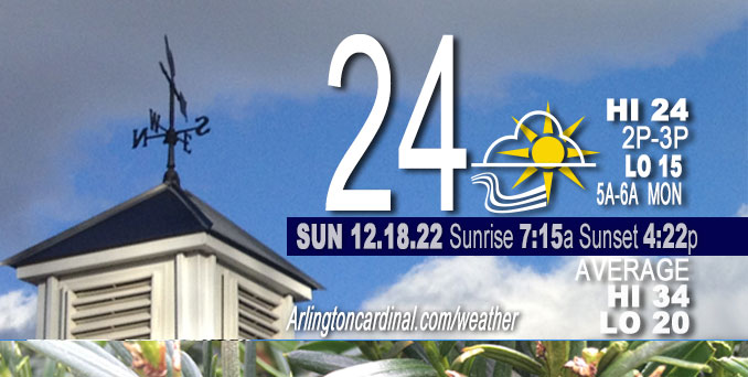
Sunday Hi 24, mostly cloudy, partly cloudy by 4p, winds W, 13 to 14 to 7 MPH, G23 to 24 to 13 MPH ending 10p
NWS CHGO | NWS HRLY | /NWSchicago | 🌡
ARLINGTON HEIGHTS WEATHER
▴ forecast7 (Arl. Hts.) | RADAR | WIDE RADAR
⏪ Hrly Data Table | Hrly Future Graph ⏩
IMPORTANT NOTE ON NWS DATA
⏪ Hrly Data Table | Hrly Future Graph ⏩
======================
Sunday and Sunday Night …
No Weather Hazards expected…
However get prepared for a low 8°F Friday morning with a high of 12°F, and then a low of 0°F Saturday morning with a high near 9°F.
DISCUSSION…
Cold is sinking in as daily highs continue on a downward trend, but the sun is forecast to make an appearance Sunday — the first significant appearance of the sun since Sunday, December 4, 2022. Clearing will occur from southwest to northeast. Satellite trends show a relatively optimistic picture for cloud cover evolution today, with nearly the entirety of Iowa and Minnesota clear as of 2:00 a.m. Sunday. While areas of stratus with some flurries still exist under a deep 2-4kft AGL (Above Ground Level) inversion across Wisconsin and into Chicagoland, the presence of several substantial holes in the cloud cover combined with increasingly smaller saturated cloud depths (supported by recent RFD AMDAR, that is Rockford Aircraft Meteorological Data Relay profiles) suggest leaning toward quicker clearing from the southwest today.
Some areas could see virga snow (flurries don’t make it to the ground).
Hello mobile users! If you encounter a mobile “unfriendly” weather page, turn your phone sideways for a better view.
======================
O’HARE FORECAST …
Forecast Beginning Sunday, Dec. 18, 2022
Sunday: Isolated flurries before 10am. Cloudy, then gradually becoming mostly sunny, with a high near 24. West wind 10 to 15 mph, with gusts as high as 25 mph.
Sunday Night: Partly cloudy, with a low around 15. West wind 5 to 10 mph, with gusts as high as 20 mph.
Monday: A chance of flurries after 3pm. Mostly cloudy, with a high near 28. West wind around 5 mph becoming south southeast in the afternoon.
Monday Night: A 20 percent chance of snow. Cloudy, with a low around 26. Southeast wind around 5 mph becoming south southwest after midnight. Winds could gust as high as 10 mph.
Tuesday: Mostly cloudy, with a high near 31. South southwest wind 5 to 10 mph becoming west northwest in the afternoon. Winds could gust as high as 15 mph.
Tuesday Night: Mostly cloudy, with a low around 14.
Wednesday: A 20 percent chance of snow after noon. Mostly cloudy, with a high near 25.
Wednesday Night: Snow likely, mainly after midnight. Cloudy, with a low around 20.
Thursday: Snow. Cloudy, with a high near 26.
Thursday Night: Snow likely, mainly before midnight. Cloudy, with a low around 8. Blustery.
Friday: A chance of snow. Mostly cloudy, with a high near 12. Blustery.
Friday Night: Mostly cloudy, with a low around 0. Blustery.
Saturday: Partly sunny and cold, with a high near 9.


CHICAGOWEATHERSTATION.COM

ChicagoWeatherStation.com I O’Hare Normal Temps/Precip I O’Hare Record Temps, Precip, Snow
LIVE RADAR | STORM TRACKS | UNISYS US IR SAT | UNISYS Midwest IR SAT | UNISYS More IR SAT
WunderMap® with Temperature/Wind Data || Google: Arlington Heights Area Temps | US TEMPS
Full Screen Motion Weather Radar (Wunderground.com)
Midwest Cloud Cover with Arlington Heights Weather Forecast
ChicagoWeatherStation.com I O’Hare Normal Temps/Precip I O’Hare Record Temps, Precip, Snow
SUNLIGHT DATA FOR SECURITY, TRAFFIC SAFETY, AND SPORTS
SunCalc.net data with solar azimuth and trajectory, times for dawn, sunrise, solar noon, sunset, dusk …
NIGHT SKY THIS MONTH …
Backyard stargazers get a monthly guide to the northern hemisphere’s skywatching events with “Tonight’s Sky.” Check the night sky objects for this month and past months in the playlist from the Space Telescope Science Institute YouTube channel (Musical track The Far River written by Jonn Serrie, from the album And the Stars Go With You courtesy of New World Music Ltd).
Get updates from The Cardinal ALL NEWS FEEDS on Facebook. Just ‘LIKE’ the ‘Arlington Cardinal Page (become a fan of our page). The updates cover all posts and sub-category posts from The Cardinal — Arlingtoncardinal.com. You can also limit feeds to specific categories. See all of The Cardinal Facebook fan pages at Arlingtoncardinal.com/about/facebook …
Help fund The Cardinal Arlingtoncardinal.com/sponsor
Area Forecast Discussion
National Weather Service Chicago/Romeoville, IL
517 AM CST Sun Dec 18 2022
.SHORT TERM… Issued at 254 AM CST Sun Dec 18 2022
Through Monday…
The upper-low that has influenced the area for several days is now located north of Georgian Bay and will continue to drift farther east through the day. We will finally see its influence over our weather come to an end, with observational trends pointing to mostly sunny skies for most by the end of the day.
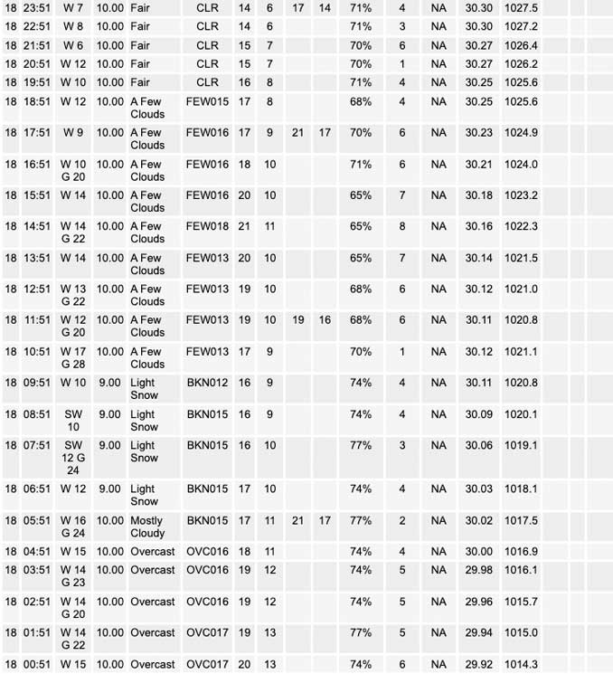
Satellite trends show a relatively optimistic picture for cloud cover evolution today, with nearly the entirety of Iowa and Minnesota clear as of 2am. While areas of stratus with some flurries still exist under a deep 2-4kft AGL inversion across Wisconsin and into the CWA, the presence of several substantial holes in the cloud cover combined with increasingly smaller saturated cloud depths (supported by recent RFD AMDAR profiles) suggest leaning toward quicker clearing from the southwest today. The one caveat will be the potential for diurnal heating to redevelop or reinforce stratus under the inversion late morning into the afternoon. Upstream dew points in the single digits will continue to advect eastward through the day, which should support large enough dew point depressions to preclude widespread thicker stratus. Overall expectations are that that southwest half of the CWA will remain mostly clear, but clearing will take until the afternoon for the northeast CWA as upstream stratus in Wisconsin will continue to filter over the area. So when all is said and done, many should see the sun for the first time in almost two weeks (December 4th).
Winds will ease tonight as a surface ridge crosses the area through Monday morning. Phasing of a northern Rockies wave and a southern High Plains wave will induce broader central CONUS low pressure that will commence modest WAA into the area by late Monday. The precip shield with the phased wave may brush the far northwest CWA by sunset. Meanwhile, mid-level moisture within broad isentropic ascent and under steep 600-400 hPa lapse rates will likely produce highly elevated snow showers late in the day elsewhere across the CWA. These should remain as virga, but a few showers may saturated down to the surface and produce spotty patches of flurries.
Kluber/NWS Chicago
