
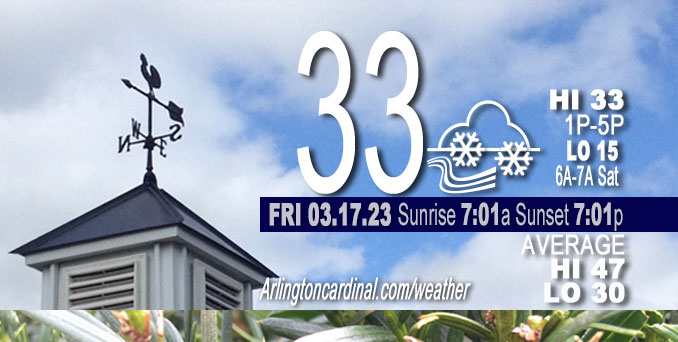
Friday Hi 33, partly sunny to partly cloudy, winds WNW, 23 to 20 MPH, G34 to 31 to 30 MPH continuing Saturday
NWS CHGO | NWS HRLY | /NWSchicago | 🌡
ARLINGTON HEIGHTS WEATHER
▴ forecast7 (Arl. Hts.) | RADAR | WIDE RADAR
⏪ Hrly Data Table | Hrly Future Graph ⏩
IMPORTANT NOTE ON NWS DATA
⏪ Hrly Data Table | Hrly Future Graph ⏩
Hello mobile users! If you encounter a mobile “unfriendly” weather page, turn your phone sideways for a better view.
======================
Friday and Friday Evening …
Weather Hazards expected …
Limited Excessive Cold Risk tonight.
Limited Non Thunderstorm Wind Risk.
DISCUSSION…
West-northwest winds will gust to 40 mph Friday morning.
======================
O’HARE FORECAST …
Forecast Beginning Friday, Mar. 17, 2023
Friday: Partly sunny, with a high near 33. Breezy, with a west wind around 25 mph, with gusts as high as 35 mph.
Friday Night: A chance of flurries between 10pm and 4am. Mostly cloudy, with a low around 15. Wind chill values as low as zero. Breezy, with a west wind around 20 mph, with gusts as high as 30 mph.
Saturday: A chance of flurries after 7am. Mostly cloudy, with a high near 28. Wind chill values as low as -2. Breezy, with a west wind around 20 mph, with gusts as high as 30 mph.
Saturday Night: Mostly cloudy, with a low around 18. Blustery, with a west northwest wind 15 to 20 mph, with gusts as high as 30 mph.
Sunday: Sunny, with a high near 41. West wind 10 to 15 mph, with gusts as high as 20 mph.
Sunday Night: Mostly clear, with a low around 25.
Monday: Mostly sunny, with a high near 50.
Monday Night: Mostly cloudy, with a low around 33.
Tuesday: Partly sunny, with a high near 53.
Tuesday Night: Mostly cloudy, with a low around 36.
Wednesday: A chance of showers. Partly sunny, with a high near 47.
Wednesday Night: Showers likely. Mostly cloudy, with a low around 43.
Thursday: Showers likely. Mostly cloudy, with a high near 55. Breezy.


CHICAGOWEATHERSTATION.COM

ChicagoWeatherStation.com I O’Hare Normal Temps/Precip I O’Hare Record Temps, Precip, Snow
LIVE RADAR | STORM TRACKS | UNISYS US IR SAT | UNISYS Midwest IR SAT | UNISYS More IR SAT
WunderMap® with Temperature/Wind Data || Google: Arlington Heights Area Temps | US TEMPS
Full Screen Motion Weather Radar (Wunderground.com)
Midwest Cloud Cover with Arlington Heights Weather Forecast
ChicagoWeatherStation.com I O’Hare Normal Temps/Precip I O’Hare Record Temps, Precip, Snow
SUNLIGHT DATA FOR SECURITY, TRAFFIC SAFETY, AND SPORTS
SunCalc.net data with solar azimuth and trajectory, times for dawn, sunrise, solar noon, sunset, dusk …
NIGHT SKY THIS MONTH …
Backyard stargazers get a monthly guide to the northern hemisphere’s skywatching events with “Tonight’s Sky.” Check the night sky objects for this month and past months in the playlist from the Space Telescope Science Institute YouTube channel (Musical track The Far River written by Jonn Serrie, from the album And the Stars Go With You courtesy of New World Music Ltd).
Get updates from The Cardinal ALL NEWS FEEDS on Facebook. Just ‘LIKE’ the ‘Arlington Cardinal Page (become a fan of our page). The updates cover all posts and sub-category posts from The Cardinal — Arlingtoncardinal.com. You can also limit feeds to specific categories. See all of The Cardinal Facebook fan pages at Arlingtoncardinal.com/about/facebook …
Help fund The Cardinal Arlingtoncardinal.com/sponsor
Area Forecast Discussion
National Weather Service Chicago/Romeoville, IL
644 AM CDT Fri Mar 17 2023
.SHORT TERM… Issued at 338 AM CDT Fri Mar 17 2023
Through Saturday…
Key Forecast Messages:
* Rain changing to snow north of I-80 briefly very early this morning before precipitation ends. No significant accumulation expected.
* Blustery west-northwest winds with gusts to 40 mph today, then gradually easing but remaining blustery through Saturday.
* Scattered flurries tonight/Saturday, with a few snow showers possible south of I-80 tonight, and near the lake in far northeast Porter county into Saturday.
* Chilly temps and wind chills for mid-March, with daytime temps in 30s today and 20s on Saturday. Lows in the teens tonight. Wind chills near zero tonight and only in the single lower teens Saturday.
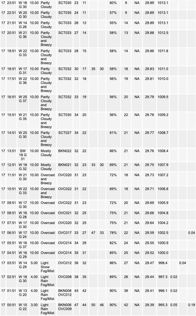
Strong surface cold front was pushing across the WFO LOT/IWX as of 08Z/3 am CDT. Blustery west-northwest winds were gusting around 35 mph in spots in the strong cold advection behind the front, with temps quickly dropping from 45-50 degrees into the 30s. Rain showers lingered behind the front to about the I-55/I-57 corridors at this hour, with an area of light snow further northwest roughly east of I- 39 and north of I-80. The rain/snow line will continue to push east across the Chicago metro over the next hour or so, though is likely to erode somewhat as it moves quickly east of the area as deeper forcing for ascent shifts northeast and the divergent left exit region of the upper jet streak outpaces strong mid-level vort over the upper Mississippi Valley. Thus, precipitation should come to an end by sunrise for most of the forecast area. Blustery west- northwest winds gusting 35-40 mph at times will continue to pull colder and drier air into the region this morning, cooling temperatures into the upper 20s/low 30s this morning. Some partial clearing this afternoon should allow a little recovery into the low- mid 30s, though the persistent blustery winds will make for wind chills only in the teens and 20s.
The upper trough over the upper Midwest and western Great Lakes region will continue to deepen across the area tonight, as another pair of mid-level vort maxima rotate cyclonically across the area and wraps additional low-level moisture into the region. 850 mb temps are progged to drop to near -20C by the pre-dawn hours of early Saturday, maintaining steep low-level lapse rates and regeneration of low level stratus/strato cu. This cloud deck will very likely support flurries across much of the area as cloud temps will be in the dendritic growth zone, and slightly higher low-level dew points south of I-80 may support deeper a convective cloud layer for snow showers. Temperatures will fall into the teens area-wide, while gusty 30-35 mph west-northwest winds send wind chills into the single digits either side of zero.
On Saturday, the eastward movement of the upper trough axis and increasingly drier low-level air should result in shallower stratocu depth and mainly just scattered flurries, especially by afternoon. Temps are only expected to reach the mid-upper 20s, some 20 degrees below average. While gradually easing through the period, northwest winds will continue to gust near 30 mph producing wind chills in the lower teens.
Low-level wind fetch will favor primarily southwest lower Michigan and adjacent north-central IN for lake effect snow shower potential, though far northeast Porter county may see scattered lake-induced snow showers late tonight into Saturday. No significant accumulation is expected.
Ratzer/NWS Chicago
