
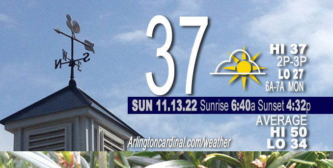
SUNDAY Hi 37-39, partly sunny to partly cloudy after 2p, winds NW, 7 to 10 to 1 MPH after 8p
NWS CHGO | NWS HRLY | /NWSchicago | 🌡
ARLINGTON HEIGHTS WEATHER
▴ forecast7 (Arl. Hts.) | RADAR | WIDE RADAR
⏪ Hrly Data Table | Hrly Future Graph ⏩
IMPORTANT NOTE ON NWS DATA
⏪ Hrly Data Table | Hrly Future Graph ⏩
======================
Sunday Nov. 13, 2022 …
No weather hazards expected…
A quieter stretch of weather is in store with an area of high pressure builds eastward into Chicagoland and the midwest. Clear skies with few clouds overnight were associated with temperatures dipping into the upper 20s around 6:00 a.m. to 7:00 a.m.
Biggest question mark for Sunday’s forecast is the cloud coverage from the stratus layer overhead. Blue sky and sunshine is punching through with a little less cloud coverage than expected. That might mean a high temperature a little higher than the official 37 high forecast for O’Hare.
Hello mobile users! If you encounter mobile “unfriendly” weather page, turn your phone sideways for a better view.
======================
O’HARE FORECAST …
Forecast Beginning Sunday, Nov. 13, 2022
Sunday: Partly sunny, with a high near 37. Northwest wind 5 to 10 mph.
Sunday Night: Mostly cloudy, with a low around 27. Northwest wind around 5 mph becoming calm.
Monday: Mostly cloudy, with a high near 42. Light southeast wind increasing to 5 to 10 mph in the morning.
Monday Night: A 50 percent chance of snow after midnight. Cloudy, with a low around 32. East southeast wind around 5 mph.
Tuesday: Snow likely. Cloudy, with a high near 38. East southeast wind around 5 mph becoming north northwest in the afternoon. Winds could gust as high as 10 mph. Chance of precipitation is 70%.
Tuesday Night: A 50 percent chance of snow. Mostly cloudy, with a low around 31.
Wednesday: Snow likely, mainly after noon. Mostly cloudy, with a high near 38. Chance of precipitation is 60%.
Wednesday Night: A chance of snow before midnight. Mostly cloudy, with a low around 26.
Thursday: A chance of snow after noon. Mostly cloudy, with a high near 33.
Thursday Night: A chance of snow before midnight. Mostly cloudy, with a low around 19.
Friday: Partly sunny, with a high near 26.
Friday Night: Partly cloudy, with a low around 16.
Saturday: Mostly sunny, with a high near 29.


CHICAGOWEATHERSTATION.COM

ChicagoWeatherStation.com I O’Hare Normal Temps/Precip I O’Hare Record Temps, Precip, Snow
LIVE RADAR | STORM TRACKS | UNISYS US IR SAT | UNISYS Midwest IR SAT | UNISYS More IR SAT
WunderMap® with Temperature/Wind Data || Google: Arlington Heights Area Temps | US TEMPS
Full Screen Motion Weather Radar (Wunderground.com)
Midwest Cloud Cover with Arlington Heights Weather Forecast
ChicagoWeatherStation.com I O’Hare Normal Temps/Precip I O’Hare Record Temps, Precip, Snow
SUNLIGHT DATA FOR SECURITY, TRAFFIC SAFETY, AND SPORTS
SunCalc.net data with solar azimuth and trajectory, times for dawn, sunrise, solar noon, sunset, dusk …
NIGHT SKY THIS MONTH …
Backyard stargazers get a monthly guide to the northern hemisphere’s skywatching events with “Tonight’s Sky.” Check the night sky objects for this month and past months in the playlist from the Space Telescope Science Institute YouTube channel (Musical track The Far River written by Jonn Serrie, from the album And the Stars Go With You courtesy of New World Music Ltd).
Get updates from The Cardinal ALL NEWS FEEDS on Facebook. Just ‘LIKE’ the ‘Arlington Cardinal Page (become a fan of our page). The updates cover all posts and sub-category posts from The Cardinal — Arlingtoncardinal.com. You can also limit feeds to specific categories. See all of The Cardinal Facebook fan pages at Arlingtoncardinal.com/about/facebook …
Help fund The Cardinal Arlingtoncardinal.com/sponsor
Area Forecast Discussion…CORRECTED
National Weather Service Chicago/Romeoville, IL
1144 AM CST Sun Nov 13 2022
.SHORT TERM… Issued at 234 AM CST Sun Nov 13 2022
Through Monday…
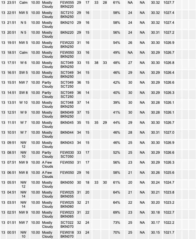
Will be a quieter stretch here in the short term as a sprawling 1030s mb area of high pressure builds eastward. Lingering lake effect snow will continue to ease and push farther east with time through the morning. A perusal of INDOT webcams indicates just wet roadways across northeastern Porter county and towards the CWA line, and with air temperatures near the lake running 33 to 36 degrees, impacts should continue to be very minimal.
Biggest question mark for today`s forecast is what happens with our stratus. An expansive hole has opened up across eastern Iowa and into central Illinois, with additional areas of clearing noted just north of the Wisconsin state line. As is often the case this time of year, guidance is pretty much useless from a cloud forecasting standpoint. Based on current trends, it looks like we`ll probably start seeing a few more holes open up over our forecast area through the morning, but with mixing into the afternoon, thinking that we may end up re-saturating with time. Low confidence how this all shakes out, but have attempted to reflect cloudy conditions this morning transitioning to partly sunny this afternoon in the gridded forecast for today, and it`s conceivable that even this is a smidge optimistic.
Gradient flow begins to return out of the south tonight into Monday morning. As this occurs, hires guidance indicates any remnant lake effect may pivot back across parts of northwest Indiana. LES parameters get high marginal during this time, but did add a sliver of sprinkles/flurries to the forecast this evening and overnight for parts of Porter County.
Monday will feature increasing high and mid-level cloud cover as a fairly pronounced lead shortwave moves across Minnesota. A dry layer under 700 mb will relegated any snow with this system well to our north and west through Monday afternoon. 925 mb temperature climatology suggests highs could push back into the 40s.
Carlaw/NWS Chicago
