
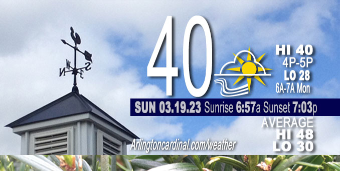
Sunday Hi 40, mostly sunny, winds WNW to W to WSW, 10 to 15 MPH, G17 to 21 MPH continuing Monday
NWS CHGO | NWS HRLY | /NWSchicago | 🌡
ARLINGTON HEIGHTS WEATHER
▴ forecast7 (Arl. Hts.) | RADAR | WIDE RADAR
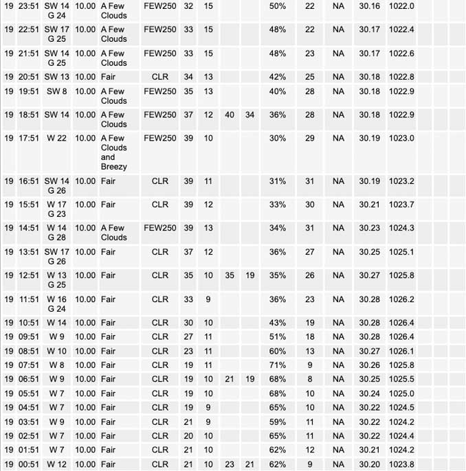
⏪ Hrly Data Table | Hrly Future Graph ⏩
IMPORTANT NOTE ON NWS DATA
⏪ Hrly Data Table | Hrly Future Graph ⏩
Hello mobile users! If you encounter a mobile “unfriendly” weather page, turn your phone sideways for a better view.
======================
Sunday and Sunday Evening …
No Weather Hazards expected …
NWS Chicago: After a rather January-like weekend, improving weather is in store for the region beginning Sunday and Monday.
DISCUSSION…
At the surface, a sprawling area of high pressure over the Plains will build southeast across the lower Mississippi Valley, allowing winds to ease and back to the west-southwest this afternoon. The high pressure will set up a gradual warming trend with afternoon highs reaching the upper 30s to around 40. While winds will be significantly lighter than over the past few days, it will remain a bit breezy with some gusts into the 20-25 mph range this afternoon.
======================
O’HARE FORECAST …
Forecast Beginning Sunday, Mar. 19, 2023
Sunday: Sunny, with a high near 40. West southwest wind around 15 mph, with gusts as high as 25 mph.
Sunday Night: Increasing clouds, with a low around 29. Southwest wind 10 to 15 mph, with gusts as high as 20 mph.
Monday: Isolated sprinkles after 1pm. Partly sunny, with a high near 50. Breezy, with a southwest wind 15 to 20 mph, with gusts as high as 35 mph.
Monday NightIsolated sprinkles before 10pm. Mostly cloudy, with a low around 36. South southwest wind 10 to 15 mph, with gusts as high as 20 mph.
Tuesday: A 20 percent chance of showers after 1pm. Partly sunny, with a high near 53. South southwest wind 10 to 15 mph, with gusts as high as 25 mph.
Tuesday Night: Showers likely, mainly before 1am. Cloudy, with a low around 41. Chance of precipitation is 70%.
Wednesday: A 50 percent chance of showers. Mostly cloudy, with a high near 56.
Wednesday Night: Showers likely, mainly after 1am. Mostly cloudy, with a low around 46.
Thursday: Showers likely. Mostly cloudy, with a high near 52.
Thursday Night: A chance of showers. Mostly cloudy, with a low around 37.
Friday: A chance of rain. Mostly cloudy, with a high near 44.
Friday Night: A chance of rain. Mostly cloudy, with a low around 33.
Saturday: Mostly sunny, with a high near 49.


CHICAGOWEATHERSTATION.COM

ChicagoWeatherStation.com I O’Hare Normal Temps/Precip I O’Hare Record Temps, Precip, Snow
LIVE RADAR | STORM TRACKS | UNISYS US IR SAT | UNISYS Midwest IR SAT | UNISYS More IR SAT
WunderMap® with Temperature/Wind Data || Google: Arlington Heights Area Temps | US TEMPS
Full Screen Motion Weather Radar (Wunderground.com)
Midwest Cloud Cover with Arlington Heights Weather Forecast
ChicagoWeatherStation.com I O’Hare Normal Temps/Precip I O’Hare Record Temps, Precip, Snow
SUNLIGHT DATA FOR SECURITY, TRAFFIC SAFETY, AND SPORTS
SunCalc.net data with solar azimuth and trajectory, times for dawn, sunrise, solar noon, sunset, dusk …
NIGHT SKY THIS MONTH …
Backyard stargazers get a monthly guide to the northern hemisphere’s skywatching events with “Tonight’s Sky.” Check the night sky objects for this month and past months in the playlist from the Space Telescope Science Institute YouTube channel (Musical track The Far River written by Jonn Serrie, from the album And the Stars Go With You courtesy of New World Music Ltd).
Get updates from The Cardinal ALL NEWS FEEDS on Facebook. Just ‘LIKE’ the ‘Arlington Cardinal Page (become a fan of our page). The updates cover all posts and sub-category posts from The Cardinal — Arlingtoncardinal.com. You can also limit feeds to specific categories. See all of The Cardinal Facebook fan pages at Arlingtoncardinal.com/about/facebook …
Help fund The Cardinal Arlingtoncardinal.com/sponsor
/////////////>
Area Forecast Discussion
National Weather Service Chicago/Romeoville, IL
631 AM CDT Sun Mar 19 2023
.SHORT TERM… Issued at 335 AM CDT Sun Mar 19 2023
Through Monday…
After a rather January-like weekend, improving weather is in store for the region today and Monday.
Early morning GOES vapor imagery depicts the deep upper low, which brought cold and blustery weather to the area over the late couple of days, pulling away to the northeast of the Great Lakes region. Strong 500 mb height rises on the order of 130+ meters were noted across the upper Midwest, indicative of deep subsidence which was resulting in clearing skies which will produce full sunshine across the region today. At the surface, a sprawling area of high pressure over the Plains will build southeast across the lower Mississippi Valley, allowing winds to ease and back to the west-southwest this afternoon. This will set up a gradual warming trend with afternoon highs reaching the upper 30s to around 40. While winds will be significantly lighter than over the past few days, it will remain a bit breezy with some gusts into the 20-25 mph range this afternoon. This is thanks to our location within the tighter surface pressure gradient along the north-northeast periphery of the surface high to our southwest.
Off to our northwest, guidance continues to depict a mid-level short wave trough tracking east-southeast from the northern Rockies tonight, which induces a weak surface wave into eastern Nebraska by morning. This will help to maintain breezy southwest winds across the area tonight as a 40-45 kt southwest low level jet develops. Winds will likely decouple quickly with sunset given our dry air mass and clear skies, though sustained winds around 10 mph should persist overnight for most areas. In the warmer Chicago metro area, better low-level mixing should support at least sporadic gustiness around 20 mph at times. This will kee Ptemps fairly steady overnight, after a quick drop into the 20s this evening. Warm advection on west-southwest flow aloft will also lead to a gradual increase in high clouds after midnight, especially across far northern IL.
The aforementioned northern Rockies short wave trough is progged to gradually deamplify as it tracks east across IL/WI on Monday. Guidance continues to depict mid-level moistening in response to warm advection and isentropic ascent (290-295 K surfaces) ahead of this feature, leading to a thickening mid-level cloud deck. Forecast soundings continue to display very steep mid-level lapse rates (00Z ECMWF 3-6 km rates of 8.5 C/km overhead in afternoon), as well as very dry air below 700 mb. Such steep lapse rates within and above the mid-level moist layer suggest the potential for some high-based showers during the afternoon, though the substantial dry layer below raises questions about whether precipitation reaches the ground or remains virga (sublimating or evaporating in the dry air below cloud base before reaching the surface). Given the magnitude of the forcing and elevated instability, as well as four consecutive ECMWF runs depicting some spotty light QPF over portions of the forecast area, have added isolated sprinkle mention to the forecast mainly north of I-80 for the Monday afternoon/early evening hours. Otherwise, stronger southwest winds will gust 30-35 mph during the day, with temperatures further moderating back to/above normal in the upper 40s and low 50s.
Ratzer/NWS Chicago
