
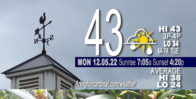
TUESDAY Hi 44, mostly cloudy, slight chance drizzle 3p to 6p, winds NE to ENE to NNW, 6 to 3 to 5 MPH
NWS CHGO | NWS HRLY | /NWSchicago | 🌡
ARLINGTON HEIGHTS WEATHER
▴ forecast7 (Arl. Hts.) | RADAR | WIDE RADAR
⏪ Hrly Data Table | Hrly Future Graph ⏩
IMPORTANT NOTE ON NWS DATA
⏪ Hrly Data Table | Hrly Future Graph ⏩
======================
Tuesday and Tuesday Night …
No Weather Hazards expected…
DISCUSSION…
Any precipitation today is expected to be relatively light, only a few hundredths of an inch. Daily high and Low temperatures through Monday, December 12, 2022 are forecast to be above normal — and notably above freezing for the morning lows as well as the afternoon highs.
Hello mobile users! If you encounter mobile “unfriendly” weather page, turn your phone sideways for a better view.
======================
O’HARE FORECAST …
Forecast Beginning Tuesday, Dec. 06, 2022
Tuesday: A 20 percent chance of rain after 3pm. Cloudy, with a high near 44. East northeast wind around 5 mph, with gusts as high as 10 mph.
Tuesday Night: A 20 percent chance of rain before 7pm. Mostly cloudy, with a low around 37. East wind around 5 mph becoming north northwest in the evening.
Wednesday: Partly sunny, with a high near 47. Northeast wind around 5 mph.
Wednesday Night: Mostly cloudy, with a low around 34. North northeast wind around 5 mph.
Thursday: A 30 percent chance of rain after noon. Cloudy, with a high near 44. East northeast wind 5 to 10 mph, with gusts as high as 20 mph.
Thursday Night: Rain, mainly after midnight. Low around 37. Chance of precipitation is 80%.
Friday: Rain, mainly before noon. High near 42. Chance of precipitation is 80%.
Friday Night: Mostly cloudy, with a low around 34.
Saturday: Mostly cloudy, with a high near 41.
Saturday Night: Mostly cloudy, with a low around 31.
Sunday: Mostly cloudy, with a high near 41.
Sunday Night: A chance of rain and snow. Mostly cloudy, with a low around 34.
Monday: A chance of rain and snow. Mostly cloudy, with a high near 43.


CHICAGOWEATHERSTATION.COM

ChicagoWeatherStation.com I O’Hare Normal Temps/Precip I O’Hare Record Temps, Precip, Snow
LIVE RADAR | STORM TRACKS | UNISYS US IR SAT | UNISYS Midwest IR SAT | UNISYS More IR SAT
WunderMap® with Temperature/Wind Data || Google: Arlington Heights Area Temps | US TEMPS
Full Screen Motion Weather Radar (Wunderground.com)
Midwest Cloud Cover with Arlington Heights Weather Forecast
ChicagoWeatherStation.com I O’Hare Normal Temps/Precip I O’Hare Record Temps, Precip, Snow
SUNLIGHT DATA FOR SECURITY, TRAFFIC SAFETY, AND SPORTS
SunCalc.net data with solar azimuth and trajectory, times for dawn, sunrise, solar noon, sunset, dusk …
NIGHT SKY THIS MONTH …
Backyard stargazers get a monthly guide to the northern hemisphere’s skywatching events with “Tonight’s Sky.” Check the night sky objects for this month and past months in the playlist from the Space Telescope Science Institute YouTube channel (Musical track The Far River written by Jonn Serrie, from the album And the Stars Go With You courtesy of New World Music Ltd).
Get updates from The Cardinal ALL NEWS FEEDS on Facebook. Just ‘LIKE’ the ‘Arlington Cardinal Page (become a fan of our page). The updates cover all posts and sub-category posts from The Cardinal — Arlingtoncardinal.com. You can also limit feeds to specific categories. See all of The Cardinal Facebook fan pages at Arlingtoncardinal.com/about/facebook …
Help fund The Cardinal Arlingtoncardinal.com/sponsor
Area Forecast Discussion
National Weather Service Chicago/Romeoville, IL
543 AM CST Tue Dec 6 2022
.SHORT TERM… Issued at 319 AM CST Tue Dec 6 2022
Through Wednesday…
Forecast focus is primarily on patchy dense fog across southern parts of the forecast area this morning, and timing and coverage of a couple of periods of light precipitation through this evening.
A weak and somewhat now diffuse cold front has pushed across parts of the forecast area since last evening, and was analyzed to be just northwest of the I-55 corridor across northern IL at 2 am CST. Not much push noted behind the front, which is expected to wash out across the southeastern cwa today. Ahead of the front, surface air and dew point temperatures were both in the mid-upper 30s resulting in areas of fog with a few localized 1/4-1/2SM dense fog reports (Peru, Morris and Sugar Grove AWOS/ASOS). Fog will likely linger past sunrise this morning given moist low levels and stalling front. At this time am not expecting visibilities below a mile to become widespread, though areas of 1-2SM fog are likely to persist past sunrise. Thus am not planning on a dense fog advisory, though will certainly continue to monitor trends in case dense fog becomes more widespread.
A little farther to the north, regional radars depict a very narrow band of frontogenetically-forced elevated returns from near the Quad Cities to near Waukegan. RAP/HRRR forecast soundings depict this forcing acting on a region of saturation generally at/above 600 mb with relatively steep (6.5+ C/km) lapse rates. Drier air was noted below that level and further low-level drying is depicted over the next few hours, which combined with expected weakening frontogenetic forcing over the next couple of hours should eventually allow this band to weaken and dissipate through sunrise as the mid-level jet streak exits. While no surface reports of precip have been noted (band is narrow and may not be sampled by AWOS/ASOS network), have maintained slight chance pops north of I-88 prior to sunrise for the potential for a few isolated sprinkles or snow flakes to make it to the surface.
Light rain is expected to redevelop along/north of I-88 by midday however, as another jet streak and associated sheared mid-level vorticity maxima develops eastward across the area and induces renewed frontogenetic forcing within the lingering baroclinic zone north of the stalled surface cold front. This will again be in a relatively narrow west-southwest to east-northeast band similar but likely a little better defined than this morning`s. Light rain is also expected to develop later this afternoon farther south along and south/east of the I-80/I-55 corridors in association with an area of low pressure propagating along the southern portion of the stalled front into southeast Missouri. Precip amounts in both areas are expected to be relatively light, only a few hundredths of an inch, and temperatures will be solidly above freezing. Dry conditions are then expected from after midnight through the day Wednesday.
Temperatures which are currently in the low-mid 30s across much of the area are expected to moderate into the low to mid 40s today, and into the mid-upper 40s Wednesday with a mix of clouds and sun.
Ratzer/NWS Chicago
