
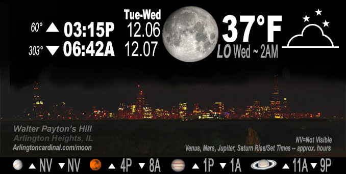
🌔 🌕 🌗 🌑 Waxing Gibbous Moon, sky cover overnight Tue. to Wed. 94% to 81%, winds ENE to NNW to N, 5 to 3 to 5 MPH, Low 37, 2a to 5a
NWS CHGO | NWS HRLY | /NWSchicago | 🌡
ARLINGTON HEIGHTS WEATHER
▴ forecast7 (Arl. Hts.) | RADAR | WIDE RADAR
IMPORTANT NOTE ON NWS DATA
======================
Overnight Tuesday/Wednesday …
No Weather Hazards expected…
DISCUSSION…
The focus on the near-term period will be a period of light rain/drizzle in the forecast Tuesday afternoon and evening in Chicagoland. Arlington Heights and the northwest suburbs have a very slight chance of drizzle from 3:00 p.m. to 6:00 p.m. Tuesday.
Low temperature forecast of 37°F for early Wednesday morning is significantly higher than the normal low temperature of 23°F for December 7.
Fog is not indicated in the forecast, but can’t be ruled out this time of year.
Hello mobile users! If you encounter mobile “unfriendly” weather page, turn your phone sideways for a better view.
======================
O’HARE FORECAST …
Forecast Beginning Tuesday Night, Dec. 6, 2022
Tuesday Night: A 20 percent chance of rain before 7pm. Mostly cloudy, with a low around 37. East wind around 5 mph becoming north northwest in the evening.
Wednesday: Partly sunny, with a high near 47. Northeast wind around 5 mph.
Wednesday Night: Mostly cloudy, with a low around 34. North northeast wind around 5 mph.
Thursday: A 30 percent chance of rain after noon. Cloudy, with a high near 44. East northeast wind 5 to 10 mph, with gusts as high as 20 mph.
Thursday Night: Rain, mainly after midnight. Low around 37. Chance of precipitation is 80%.
Friday: Rain, mainly before noon. High near 42. Chance of precipitation is 80%.
Friday Night: Mostly cloudy, with a low around 34.
Saturday: Mostly cloudy, with a high near 41.
Saturday Night: Mostly cloudy, with a low around 31.
Sunday: Mostly cloudy, with a high near 41.
Sunday Night: A chance of rain and snow. Mostly cloudy, with a low around 34.
Monday: A chance of rain and snow. Mostly cloudy, with a high near 43.
O’Hare forecast archive and hourly weather observations archive are available HERE on the CARDINAL NEWS Magazine.
Arlingtoncardinal.com/moonphases
Arlingtoncardinal.com/nightsky
NIGHT SKY THIS MONTH …
Check the night sky objects for this month and past months in the playlist from the Space Telescope Science Institute YouTube channel Backyard stargazers get a monthly guide to the northern hemisphere’s skywatching events with “Tonight’s Sky” (Musical track The Far River written by Jonn Serrie, from the album And the Stars Go With You courtesy of New World Music Ltd. Musical track The Far River written by Jonn Serrie, from the album And the Stars Go With You courtesy of New World Music Ltd).
Telephoto lens, ISO 100, f/11, Shutter Speed 1/100 to 1/125 for the Moon.
Get updates from The Cardinal ALL NEWS FEEDS on Facebook. Just ‘LIKE’ the ‘Arlington Cardinal Page (become a fan of our page). The updates cover all posts and sub-category posts from The Cardinal — Arlingtoncardinal.com. You can also limit feeds to specific categories. See all of The Cardinal Facebook fan pages at Arlingtoncardinal.com/about/facebook …
Help fund The Cardinal Arlingtoncardinal.com/sponsor
Telephoto lens, ISO 1600, f/11, Shutter Speed 2.5″ for the skyline. The skyline exposure was toned down, and brightness and contrast was adjusted in Photoshop.
Area Forecast Discussion
National Weather Service Chicago/Romeoville, IL
1128 PM CST Tue Dec 6 2022
.UPDATE… Issued at 919 PM CST Tue Dec 6 2022
No big changes to going forecast, though did hit the fog a bit harder tonight, particularly northern and western CWA. Several different cloud layers in the region this evening as well as a sizable area of partial clearing across northern 1/3rd of the CWA. Already seeing ground fog developing in the clearing areas, unsurprisingly given the light winds and small dewpoint depressions.
Also watching a couple different areas of stratus, each expanding toward or across our CWA…
The first area over southern and western portions of the CWA is largely MVFR with pockets of IFR. Recent PIREP has this stratus deck at only about 500ft thick, so not particularly thick which may allow for some slight cooling beneath the stratus. Evening sounding from ILX shows fairly moist low levels right up to the inversion, which would also favor some stratus build down. Soil temps in these areas are generally in the mid to upper 30s, which is pretty close to crossover temperatures, suggesting that the stratus may tend to build downward at a more modest (100-200ft/hour) rate. Given some pockets of IFR, certainly seems plausible that at least patchy dense fog will occur beneath this stratus deck.
The second stratus deck is over southern WI and that deck is much lower and expanding south toward the IL state line. This stratus deck (along with deepening radiational ground fog in the areas that cleared out) seem to pose the bigger risk of dense fog tonight.
Anywhere fog develops should see it persist well past sunrise and if the expanding low stratus/fog deck over WI hits the deck it is possible that dense fog could continue to expand south and southeast across our CWA even well after sunrise Wednesday. Seems quite plausible that a dense fog advisory will eventually be needed for at least portions of our CWA, but given the difficulty in predicting fog, plan to let midnight shift handle any fog headlines as the fog tips its hand a bit more.
One other note, is that temps in the dense fog areas over our NW CWA should be close to or below freezing. Freezing fog could result in some slick spots tomorrow morning, particularly on bridges and overpasses.
– Izzi/NWS Chicago
