
🌔 🌕 🌗 🌑 Waxing Gibbous Moon, sky cover overnight Fri. to Sat. 84% to 100%, winds S, 17 to 25 MPH, G29 to 50 MPH, 7p to 8a, Low 45, 10p to 12a Sat.
NWS CHGO | NWS HRLY | /NWSchicago | 🌡
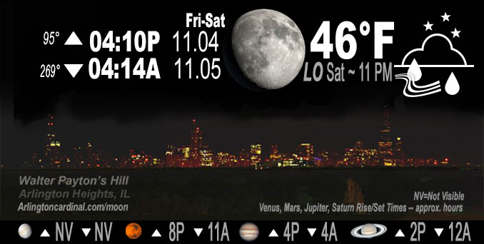
ARLINGTON HEIGHTS WEATHER
▴ forecast7 (Arl. Hts.) | RADAR | WIDE RADAR
IMPORTANT NOTE ON NWS DATA
======================
Friday night …
Weather hazards expected…
Limited Thunderstorm Risk…with an associated:
Limited damaging wind risk…up to 60 mph
Elevated Non Thunderstorm Wind Risk.
DISCUSSION…
Rain, with some embedded thunderstorms, will overspread the area overnight. One or two of the storms could produce locally damaging winds, mainly across northwest Indiana and south of Interstate 55 in Illinois. Outside of any thunderstorms, winds could still occasionally gust to around 40 mph.
Wind gusts from the south expected to increase beginning about 35 to 40 MPH at 4:00 AM to about 52 MPH by 9:00 AM.
======================
Wind Advisory
URGENT – WEATHER MESSAGE
National Weather Service Chicago IL
939 PM CDT Fri Nov 4 2022
Winnebago-Boone-McHenry-Lake IL-Ogle-Lee-De Kalb-Kane-DuPage- Northern Cook-Central Cook-Southern Cook-Lake IN-Porter- Including the cities of Rockford, Belvidere, Crystal Lake, Algonquin, McHenry, Woodstock, Waukegan, Buffalo Grove, Mundelein, Gurnee, Rochelle, Oregon, Byron, Dixon, DeKalb, Sycamore, Aurora, Elgin, Naperville, Wheaton, Downers Grove, Lombard, Carol Stream, Evanston, Des Plaines, Schaumburg, Palatine, Northbrook, Chicago, Cicero, Oak Lawn, Oak Park, La Grange, Calumet City, Oak Forest, Lemont, Orland Park, Park Forest, Gary, Hammond, Merrillville, Portage, Valparaiso, and Chesterton
939 PM CDT Fri Nov 4 2022
…WIND ADVISORY REMAINS IN EFFECT FROM 4 AM TO 7 PM CDT SATURDAY…
* WHAT…South to southwest winds 25 to 30 mph with gusts up to 55 mph expected.
* WHERE…Portions of north central and northeast Illinois and northwest Indiana.
* WHEN…From 4 AM to 7 PM CDT Saturday.
* IMPACTS…Prepare for downed tree limbs and scattered power outages. Unsecured objects such as decorations and lawn furniture may blow away.
PRECAUTIONARY/PREPAREDNESS ACTIONS…
Use extra caution when driving, especially if operating a high profile vehicle. Secure outdoor objects.
O’HARE FORECAST …
Forecast Beginning Friday Night, Nov. 04, 2022
Tonight: Scattered showers, then showers and possibly a thunderstorm after 2am. Low around 60. Breezy, with a south wind 15 to 20 mph, with gusts as high as 35 mph. Chance of precipitation is 100%. New rainfall amounts between a tenth and quarter of an inch, except higher amounts possible in thunderstorms.
Saturday: Showers likely, mainly before noon. Cloudy, with a temperature falling to around 48 by 4pm. Windy, with a southwest wind around 30 mph, with gusts as high as 55 mph. Chance of precipitation is 60%. New precipitation amounts between a tenth and quarter of an inch possible.
Saturday Night: Partly cloudy, with a low around 45. Breezy, with a south southwest wind 20 to 25 mph decreasing to 10 to 15 mph after midnight. Winds could gust as high as 35 mph.
Sunday: Mostly sunny, with a high near 62. South southwest wind 10 to 15 mph, with gusts as high as 25 mph.
Sunday Night: Mostly clear, with a low around 42. West wind around 5 mph becoming north northwest after midnight. Winds could gust as high as 15 mph.
Monday: Sunny, with a high near 56.
Monday Night: Mostly cloudy, with a low around 44.
Tuesday: Partly sunny, with a high near 57.
Tuesday Night: Partly cloudy, with a low around 47.
Wednesday: Mostly sunny, with a high near 65.
Wednesday Night: Partly cloudy, with a low around 51.
Thursday: Partly sunny, with a high near 66.
Thursday Night: A chance of rain. Mostly cloudy, with a low around 44.
Veterans Day: A chance of rain. Mostly cloudy, with a high near 54.
O’Hare forecast archive and hourly weather observations archive are available HERE on the CARDINAL NEWS Magazine.
Arlingtoncardinal.com/moonphases
Arlingtoncardinal.com/nightsky
NIGHT SKY THIS MONTH …
Check the night sky objects for this month and past months in the playlist from the Space Telescope Science Institute YouTube channel Backyard stargazers get a monthly guide to the northern hemisphere’s skywatching events with “Tonight’s Sky” (Musical track The Far River written by Jonn Serrie, from the album And the Stars Go With You courtesy of New World Music Ltd. Musical track The Far River written by Jonn Serrie, from the album And the Stars Go With You courtesy of New World Music Ltd).
Telephoto lens, ISO 100, f/11, Shutter Speed 1/100 to 1/125 for the Moon.
Get updates from The Cardinal ALL NEWS FEEDS on Facebook. Just ‘LIKE’ the ‘Arlington Cardinal Page (become a fan of our page). The updates cover all posts and sub-category posts from The Cardinal — Arlingtoncardinal.com. You can also limit feeds to specific categories. See all of The Cardinal Facebook fan pages at Arlingtoncardinal.com/about/facebook …
Help fund The Cardinal Arlingtoncardinal.com/sponsor
Telephoto lens, ISO 1600, f/11, Shutter Speed 2.5″ for the skyline. The skyline exposure was toned down, and brightness and contrast was adjusted in Photoshop.
Area Forecast Discussion
National Weather Service Chicago/Romeoville, IL
926 PM CDT Fri Nov 4 2022
.UPDATE…
Issued at 922 PM CDT Fri Nov 4 2022
No big changes planned this evening, going forecast looks to be in good shape.
Should see a dramatic ramp up in winds early Saturday morning, particularly as the warm conveyor belt shifts east. There should be an envelope of strong, potentially damaging southerly winds ahead of the cold front and associated squall line. Always very tricky in warm sector, warm air advection set-up determining how effectively the boundary layer will mix. Assuming there is a several hour break in precip between the warm conveyor and squall line, it seems quite reasonable that boundary layer could deepen some and begin to tap into some of the extremely strong winds just off the deck. Working in favor of this scenario is the very strong pressure falls over WI tomorrow morning in advance of the rapidly moving and rapidly deepening sfc low. There is certainly potential for 50kt+ gusts if rain doesn`t linger and keep things a bit more stable. Opted to hold off on upgrading to a high wind warning on this shift, but think the chances are slowly increasing that there will be at least scattered 50kt+ gusts, especially eastern and southern CWA.
Threat of thunder & lightning tonight (and Saturday morning) is low, however as trough becomes negatively tilted overnight and cyclone begins to rapidly intensify very strong forcing could result in some convective elements within and especially along the leading edge of the encroaching warm conveyor developing. Given the extremely strong low level jet, cannot rule out a damaging wind threat with any of these type of convective elements overnight, especially if they can becoming oriented more orthogonal to the LLJ. Threat of this is low, with southern CWA favored due to lower static stability.
Squall line is likely to accompany cold front that will rapidly sweep across the CWA mid-late morning Saturday. Certainly plausible we could see 45-55kt gusts with this squall line, though many areas could already be gusting that strong out ahead of the squall line. In the wake of the cold front, could see a couple hours of potentially flirting with 50kt+ gusts before strongest pressure rises shift north into Wisconsin and wind fields slowly abate mid-late afternoon.
– Izzi/NWS Chicago
