
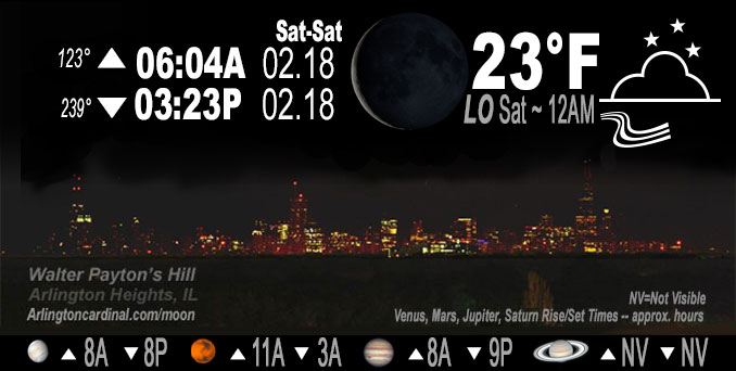
🌘 🌑 🌗 🌕 Waning Crescent Moon, sky cover overnight Fri. to Sat. 5% to 4& to 7%, winds SW, 7 to 15 MPH, G14 to 31 to 28 MPH, Low 23, 12a to 1a
NWS CHGO | NWS HRLY | /NWSchicago | 🌡
ARLINGTON HEIGHTS WEATHER
▴ forecast7 (Arl. Hts.) | RADAR | WIDE RADAR
IMPORTANT NOTE ON NWS DATA
======================
NIGHT FORECASTS …
NOTE: Keep in mind lunar rise and set times don’t always correspond with night weather and early morning lows because on some days during the month the moon is visible in the sky predominantly during the daytime hours.
Overnight Friday/Saturday …
No Weather Hazards expected
High res guidance suggests we will clear up this evening as the inversion drops and we gain some distance from low level dewpoints. Meanwhile, temperatures across the Chicagoland have only managed to climb into the lower and middle 20s with the cooler readings showing up in the northwest with the fresh snowpack.
DISCUSSION…
Temperatures rising overnight. Late this evening, a surface high propagating to our southeast will bring mild return flow to the region and slowly warm temperatures up through the night with the help of some modest WAA aloft as height rises occur behind the departing trough.
Hello mobile users! If you encounter mobile “unfriendly” weather page, turn your phone sideways for a better view.
======================
O’HARE FORECAST …
Forecast Beginning Friday Night, Feb. 17, 2023 …
Friday Night: Clear, with a temperature rising to around 26 by 5am. Southwest wind 5 to 15 mph, with gusts as high as 30 mph.
Saturday: Increasing clouds, with a high near 43. Southwest wind around 15 mph, with gusts as high as 30 mph.
Saturday Night: Mostly cloudy, with a low around 35. South southwest wind 10 to 15 mph, with gusts as high as 25 mph.
Sunday: Partly sunny, with a high near 47. South southwest wind around 15 mph, with gusts as high as 25 mph.
Sunday Night: Mostly cloudy, with a low around 29.
Monday: Washington’s Birthday: Partly sunny, with a high near 41.
Monday Night: Mostly cloudy, with a low around 33.
Tuesday: Partly sunny, with a high near 43.
Tuesday Night: A chance of rain and snow after midnight. Mostly cloudy, with a low around 31.
Wednesday: A chance of rain and snow. Mostly cloudy, with a high near 39.
Wednesday Night: Rain likely. Mostly cloudy, with a low around 33. Breezy.
Thursday: A chance of rain. Mostly cloudy, with a high near 46. Breezy.
O’Hare forecast archive and hourly weather observations archive are available HERE on the CARDINAL NEWS Magazine.
Arlingtoncardinal.com/moonphases
Arlingtoncardinal.com/nightsky
NIGHT SKY THIS MONTH …
Check the night sky objects for this month and past months in the playlist from the Space Telescope Science Institute YouTube channel Backyard stargazers get a monthly guide to the northern hemisphere’s skywatching events with “Tonight’s Sky” (Musical track The Far River written by Jonn Serrie, from the album And the Stars Go With You courtesy of New World Music Ltd. Musical track The Far River written by Jonn Serrie, from the album And the Stars Go With You courtesy of New World Music Ltd).
Telephoto lens, ISO 100, f/11, Shutter Speed 1/100 to 1/125 for the Moon.
Get updates from The Cardinal ALL NEWS FEEDS on Facebook. Just ‘LIKE’ the ‘Arlington Cardinal Page (become a fan of our page). The updates cover all posts and sub-category posts from The Cardinal — Arlingtoncardinal.com. You can also limit feeds to specific categories. See all of The Cardinal Facebook fan pages at Arlingtoncardinal.com/about/facebook …
Help fund The Cardinal Arlingtoncardinal.com/sponsor
Telephoto lens, ISO 1600, f/11, Shutter Speed 2.5″ for the skyline. The skyline exposure was toned down, and brightness and contrast was adjusted in Photoshop.
Area Forecast Discussion
National Weather Service Chicago/Romeoville, IL
1112 PM CST Fri Feb 17 2023
.SHORT TERM… Issued at 305 PM CST Fri Feb 17 2023
Through Saturday night…
A bit more cloud cover out there today than previously forecast thanks to a thin layer of saturation tucked underneath the temperature inversion rooted near 900mb. Sunny skies grace the northwest third of the CWA where dewpoints underneath the inversion are just a bit cooler. High res guidance suggests we will clear up this evening as the inversion drops and we gain some distance from low level dewpoints. Meanwhile, temperatures across the CWA have only managed to climb into the lower and middle 20s with the cooler readings showing up in the northwest with the fresh snowpack. Late this evening, a surface high propagating to our southeast will bring mild return flow to the region and slowly warm temperatures up through the night with the help of some modest WAA aloft as height rises occur behind the departing trough. The continued WAA will pull temperatures into the upper 30s in the north and upper 40s in the south. Late Saturday night, some models are throwing up some scattered sprinkles or flurries underneath a notable low level jet max on the lee side of an 850mb trough. Looking at forecast soundings, it appears that we shouldn`t have any cloud ice in place which should lead to liquid precip, if any, despite surface temps dropping into the mid 30s. The question that remains is whether we will have the moisture availability to produce light precip. For now, just included a chance for sprinkles area-wide overnight.
Doom/NWS Chicago
&&
.LONG TERM… Issued at 305 PM CST Fri Feb 17 2023
Sunday through Friday…
Key Messages:
* Mostly quiet weather through Tuesday with a pair of mainly dry cold frontal passages
* Monitoring a mid-week system that brings widespread precipitation to the region, potentially as a wintry mix for some
At the start of the upcoming week the upper pattern features broad positively tilted troughing across the western half of the CONUS with an attendant closed upper low off the coast of southern California. This feature likely brings our next best chance for widespread precipitation including a wintry mix later in the week.
Spotty showers/sprinkles will be on their way out toward daybreak Sunday with temperatures then warming into the upper 40s and lower 50s thanks to breezy southwest winds. A cold front moves through later in the day which will bring a quick shot of colder air Sunday night with lows in the 20s to near 30. Right on its heels a shortwave dives out of the northern Plains toward the area on Monday. Latest guidance continues to keep the majority of the precipitation either side of the forecast area Monday night into Tuesday so will maintain a mainly precipitation free forecast through this period. Cannot fully rule out light snow along the front as it moves through. As this system departs a shar Pbaroclinic zone sets up across the region which likely plays a role in the eventual precipitation type(s) we see with our next weather system depending on its placement.
By midweek the previously mentioned closed upper low ejects northeast out of the desert southwest across the Central Plains toward the area with an associated strengthening surface low. At this range confidence in widespread precipitation is high with this system Wednesday into Thursday. There still remains uncertainty with the finer details including precipitation type, the chance of thunder, and timing of peak rates. Despite being several days out and with shifts in the storm track expected, given the current consistent signal among the latest operational runs of the global guidance felt comfortable introducing a mention of freezing rain and sleet across our northern forecast area rather than just a rain/snow mix. We will continue to monitor this system over the coming days. Stay tuned!
Petr/NWS Chicago
