
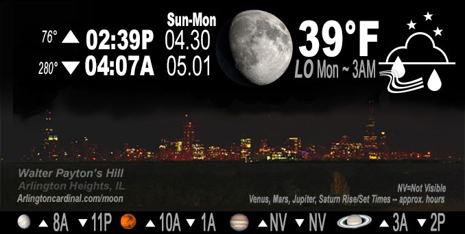
🌔 🌕 🌗 🌑 Waxing Gibbous Moon, sky cover overnight Sun. to Mon. 98% to 100%, light rain all night, winds NW, 17 to 20 to 17 to 22 MPH, G29 to 37 MPH increasing Monday, Low 41, 6a to 9a
NWS CHGO | NWS HRLY | /NWSchicago | 🌡
ARLINGTON HEIGHTS WEATHER
▴ forecast7 (Arl. Hts.) | RADAR | WIDE RADAR
IMPORTANT NOTE ON NWS DATA
Hello mobile users! If you encounter a mobile “unfriendly” weather page, turn your phone sideways for a better view.
======================
NIGHT FORECASTS …
NOTE: Keep in mind lunar rise and set times don’t always correspond with night weather and early morning lows because on some days during the month the moon is visible in the sky predominantly during the daytime hours.
Overnight Sunday to Monday …
Weather Hazards expected …
Limited Non Thunderstorm Wind Risk.
DISCUSSION…
West northwesterly wind gusts of 30 to 35 mph are likely tonight, and will increasing during the day on Monday.
======================
O’HARE FORECAST …
Forecast Beginning Sunday Night, Apr. 30, 2023 …
Sunday Night: Scattered showers before 4am, then a chance of rain after 4am. Cloudy, with a low around 39. West northwest wind around 15 mph, with gusts as high as 25 mph. Chance of precipitation is 40%.
Monday: Rain, mainly after 7am. High near 44. Breezy, with a west northwest wind 20 to 25 mph, with gusts as high as 40 mph. Chance of precipitation is 90%. New precipitation amounts between a quarter and half of an inch possible.
Monday Night: A 50 percent chance of rain. Cloudy, with a low around 38. Breezy, with a northwest wind 20 to 25 mph, with gusts as high as 40 mph.
Tuesday: A 20 percent chance of showers. Mostly cloudy, with a high near 50. Breezy, with a northwest wind around 20 mph, with gusts as high as 30 mph.
Tuesday Night: Partly cloudy, with a low around 36. North northwest wind 10 to 15 mph, with gusts as high as 25 mph.
Wednesday: Mostly sunny, with a high near 58.
Wednesday Night: Partly cloudy, with a low around 40.
Thursday: Mostly sunny, with a high near 62.
Thursday Night: Partly cloudy, with a low around 45.
Friday: Partly sunny, with a high near 63.
Friday Night: Partly cloudy, with a low around 46.
Saturday: Mostly sunny, with a high near 64.
Saturday Night: Partly cloudy, with a low around 48.
Sunday: Mostly sunny, with a high near 68.
O’Hare forecast archive and hourly weather observations archive are available HERE on the CARDINAL NEWS Magazine.
Arlingtoncardinal.com/moonphases
Arlingtoncardinal.com/nightsky
NIGHT SKY THIS MONTH …
Check the night sky objects for this month and past months in the playlist from the Space Telescope Science Institute YouTube channel Backyard stargazers get a monthly guide to the northern hemisphere’s skywatching events with “Tonight’s Sky” (Musical track The Far River written by Jonn Serrie, from the album And the Stars Go With You courtesy of New World Music Ltd. Musical track The Far River written by Jonn Serrie, from the album And the Stars Go With You courtesy of New World Music Ltd).
Telephoto lens, ISO 100, f/11, Shutter Speed 1/100 to 1/125 for the Moon.
Get updates from The Cardinal ALL NEWS FEEDS on Facebook. Just ‘LIKE’ the ‘Arlington Cardinal Page (become a fan of our page). The updates cover all posts and sub-category posts from The Cardinal — Arlingtoncardinal.com. You can also limit feeds to specific categories. See all of The Cardinal Facebook fan pages at Arlingtoncardinal.com/about/facebook …
Help fund The Cardinal Arlingtoncardinal.com/sponsor
Telephoto lens, ISO 1600, f/11, Shutter Speed 2.5″ for the skyline. The skyline exposure was toned down, and brightness and contrast was adjusted in Photoshop.
/////////////>
Area Forecast Discussion
National Weather Service Chicago/Romeoville, IL
958 PM CDT Sun Apr 30 2023
.UPDATE… Issued at 958 PM CDT Sun Apr 30 2023
The forecast is largely on track into Monday, with some minor adjustments to PoP trends. Based off recent radar trends, expect additional generally light shower activity to pinwheel in through a good chunk of the overnight. Deformation axis steady rain will probably take until daybreak or a bit after to push south into northeast Illinois and far northwest Indiana. With well above freezing temperatures, dew point temps, and thus wet bulbs and this thinking in mind, kept chance of wet snow for far northern Illinois confined to beyond sunrise tomorrow (Monday).
Forecast soundings are close enough to snow in our far north that it wouldn`t be surprising for wet snow to mix in if not a brief full changeover between about 7am and 10am. However, do not expect any accumulations. The main story will be the blustery, cold, and rainy conditions for especially northeast half or two third of the CWA to kick off the month of May.
Castro
&&
.SHORT TERM… Issued at 240 PM CDT Sun Apr 30 2023
Through Monday night…
Additional waves of rain showers and some intermittent graupel will continue this afternoon. The next batch of more cohesive precipitation is pushing south of the Wisconsin state line at the leading edge of a well-defined 700-600 mb vort max and attendant jet streak which show up nicely in mid-level water vapor loops. This should help drive higher coverage of stratiform precipitation into the Chicago area through 5-6 PM. Additional sprockets of enhanced DCVA will drift southward this evening which will yield continued off-and-on precip chances although coverage should gradually diminish.
The next vort max/jetstreak combo (currently arcing westward across Lake Superior) will drift southward into the region very late tonight and into Monday. Have noted a bit of an eastward wobble in the placement of this next feature, and some guidance today suggests that locales west of about a Rochelle to Paxton line may remain in a generally more subsident regime and yielding more limited (to even no) precipitation coverage. Have trimmed PoPs a bit for these locales, although suspect continued minor wobbles with this next disturbance may continue. Highest rain chances will be east of about a Harvard to Rensselaer line. Thermal profiles look more supportive of snow mixing in Monday morning, mainly north of I-88 as wetbulb temperatures dip down towards 37 degrees or so.
Winds should be a bit stronger on Monday compared to today as a robust 925-850 mb LLJ core pivots farther east. Not sure just how efficiently we`ll mix into the strongest winds aloft given anticipated widespread stratus, but if deeper mixing can be realized (especially if less precipitation develops in our SW locales), could need a Wind Advisory for parts of the area. Currently, thinking things should stay just under thresholds, and advertising 35-45 mph gusts tomorrow. We should see a gradual decrease in precip coverage through Monday night as the bulk of the parent upper low starts to peel away.
Carlaw/NWS Chicago
