
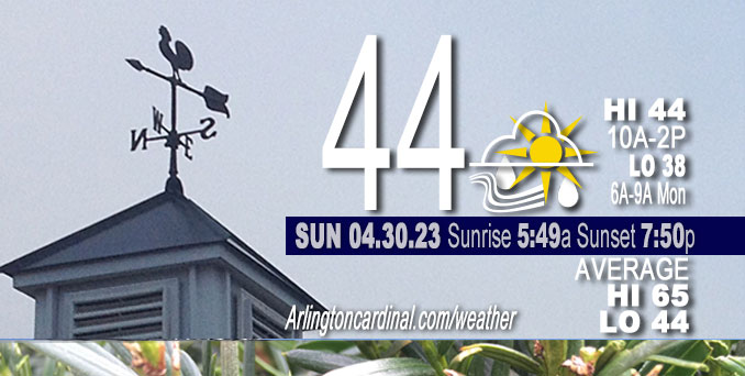
Sunday Hi 44, partly sunny to mostly cloudy, winds W to WNW to NW, 10 to 19 to 18 MPH, G20 to 30 MPH, 7a into Monday
NWS CHGO | NWS HRLY | /NWSchicago | 🌡
ARLINGTON HEIGHTS WEATHER
▴ forecast7 (Arl. Hts.) | RADAR | WIDE RADAR
⏪ Hrly Data Table | Hrly Future Graph ⏩
IMPORTANT NOTE ON NWS DATA
⏪ Hrly Data Table | Hrly Future Graph ⏩
Hello mobile users! If you encounter a mobile “unfriendly” weather page, turn your phone sideways for a better view.
======================
Sunday and Sunday Evening …
Weather Hazards expected …
Limited Non Thunderstorm Wind Risk.
DISCUSSION…
West northwesterly wind gusts of 30 to 35 mph are likely Sunday — increasing Monday.
======================
O’HARE FORECAST …
Forecast Beginning Sunday, Apr. 30, 2023
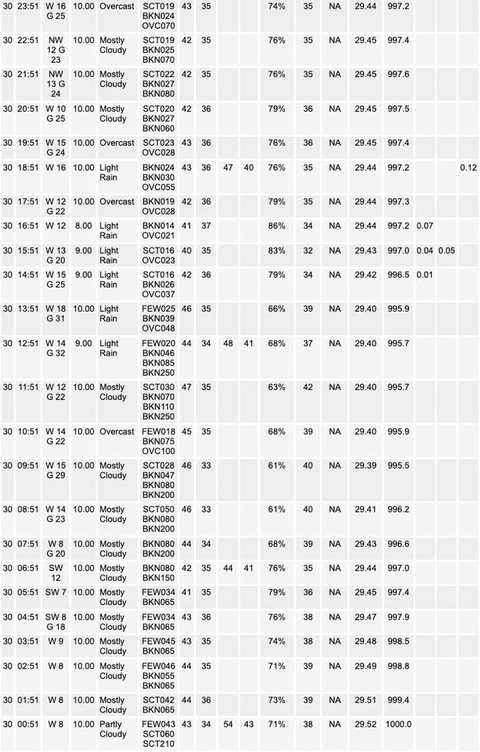
Sunday: Showers, mainly after noon. High near 44. Breezy, with a west wind 10 to 20 mph, with gusts as high as 30 mph. Chance of precipitation is 80%. New precipitation amounts of less than a tenth of an inch possible.
Sunday Night: Showers likely, mainly after 4am. Cloudy, with a low around 38. Breezy, with a west northwest wind 15 to 20 mph, with gusts as high as 30 mph. Chance of precipitation is 70%. New precipitation amounts of less than a tenth of an inch possible.
Monday: Showers. High near 44. Breezy, with a west northwest wind 20 to 25 mph, with gusts as high as 40 mph. Chance of precipitation is 90%. New precipitation amounts between a tenth and quarter of an inch possible.
Monday Night: A 30 percent chance of showers before 1am. Mostly cloudy, with a low around 39. Breezy, with a northwest wind 20 to 25 mph, with gusts as high as 40 mph.
Tuesday: Mostly cloudy, with a high near 49. Breezy, with a northwest wind around 20 mph, with gusts as high as 30 mph.
Tuesday Night: Partly cloudy, with a low around 36.
Wednesday: Mostly sunny, with a high near 58.
Wednesday Night: Partly cloudy, with a low around 40.
Thursday: Mostly sunny, with a high near 64.
Thursday Night: Partly cloudy, with a low around 46.
Friday: Mostly sunny, with a high near 63.
Friday Night: Partly cloudy, with a low around 47.
Saturday: Mostly sunny, with a high near 66.


CHICAGOWEATHERSTATION.COM

ChicagoWeatherStation.com I O’Hare Normal Temps/Precip I O’Hare Record Temps, Precip, Snow
WunderMap® with Temperature/Wind Data || Google: Arlington Heights Area Temps | US TEMPS
Midwest Cloud Cover with Arlington Heights Weather Forecast
ChicagoWeatherStation.com I O’Hare Normal Temps/Precip I O’Hare Record Temps, Precip, Snow
SUNLIGHT DATA FOR SECURITY, TRAFFIC SAFETY, AND SPORTS
SunCalc.net data with solar azimuth and trajectory, times for dawn, sunrise, solar noon, sunset, dusk …
NIGHT SKY THIS MONTH …
Backyard stargazers get a monthly guide to the northern hemisphere’s skywatching events with “Tonight’s Sky.” Check the night sky objects for this month and past months in the playlist from the Space Telescope Science Institute YouTube channel (Musical track The Far River written by Jonn Serrie, from the album And the Stars Go With You courtesy of New World Music Ltd).
Get updates from The Cardinal ALL NEWS FEEDS on Facebook. Just ‘LIKE’ the ‘Arlington Cardinal Page (become a fan of our page). The updates cover all posts and sub-category posts from The Cardinal — Arlingtoncardinal.com. You can also limit feeds to specific categories. See all of The Cardinal Facebook fan pages at Arlingtoncardinal.com/about/facebook …
Help fund The Cardinal Arlingtoncardinal.com/sponsor
/////////////>
Area Forecast Discussion
National Weather Service Chicago/Romeoville, IL
620 AM CDT Sun Apr 30 2023
.SHORT TERM… Issued at 305 AM CDT Sun Apr 30 2023
Through Monday evening…
Key Messages:
* Expect a downright cool, rainy, and windy start to the week – Rain areawide SUN-MON with decreasing coverage overnight – Wind chills in the upper 20s to 30s through TUE AM – 30-35 mph wind gusts SUN and 35-40+ mph gusts MON
As expected the sprawling closed upper low has become established across the western Great Lakes and will be responsible for the less than stellar weather conditions to end April and start the month of May. The associated surface low is in turn anticipated to deepen with time with the surface pressure gradient tightening in response. Accordingly, expect wind speeds and gusts to increase steadily through the day today aided by a cold advective regime which will allow for higher gusts to mix down to the surface. Wind gusts of 25 to 35 mph will become commonplace later today and persist overnight, highest the farther southwest you go. Monday looks to be the windiest with gusts to 35 to 40+ mph. A consideration for Wind Advisory issuance may be needed with later forecast updates, especially if wind speeds end up overperforming today.
Being so close to the 500hPa low roughly over central Lake Michigan, several vort lobes will round the low across the area which would support nearly continuous periods of rain through Monday afternoon, at times possibly mixed with snow and graupel today and Monday. Rain is expected to overspread the area through the morning hours today from northwest to southeast – likely to be areawide by early afternoon. Coverage of showers may decrease some overnight but expect another area of rain to spread across much of the area on Monday morning. The rain will gradually come to an end Monday evening.
Despite temperatures well above freezing, we very well might see snowflakes and/or graupel falling at times today and tomorrow. The best potential looks to favor the morning hours or within any of the more robust showers during the afternoons. Model guidance even tries to accumulate snow in far northeast Illinois. Think this is likely overdone, but woudn`t be surprised if a slushy coating occurs on elevated surfaces Monday morning.
I think it goes without saying to hold off on putting away the winter jackets until this system exits the region. The rain combined with gusty winds and temperatures only in the 40 will keep wind chills in the upper 20s to 30s through Tuesday morning.
Petr/NWS Chicago
