
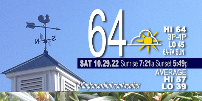
SATURDAY Hi 64°F, fog clearing, mostly sunny, winds SE to ESE to SE, 3 to 1 to 7 to 3 MPH
NWS CHGO | NWS HRLY | /NWSchicago | 🌡
ARLINGTON HEIGHTS WEATHER
▴ forecast7 (Arl. Hts.) | RADAR | WIDE RADAR
⏪ Hrly Data Table | Hrly Future Graph ⏩
IMPORTANT NOTE ON NWS DATA
⏪ Hrly Data Table | Hrly Future Graph ⏩
======================
No watches or warnings issued near O’Hare at 6:00 a.m. Saturday.
Updates at Arlingtoncardinal.com/NWSChicago
Saturday and Saturday Night.
No weather hazards expected…
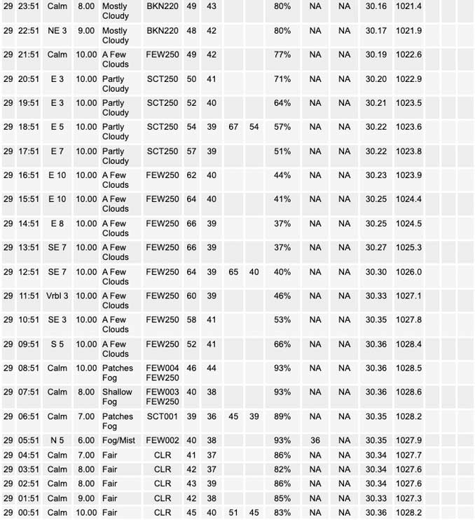
Portions of McHenry County and northwest Lake County so far have had the most persistent areas of fog over the past couple of early morning hours, but continued radiational cooling is expected to cause additional visibility drops to continue and an expansion of the lower visibilities in McHenry and Lake down into portions of Cook and DuPage counties.
Fog will dissipate by mid morning, and clear skies and warmer temperature to the mid 60s will be the weather features for Saturday across most of Chicagoland. Expect only upper 50s along the Illinois shoreline areas.
A Dense Fog Advisory activated at 5:44 a.m. covers Sheboygan, Washington, Ozaukee, Waukesha, Milwaukee, Walworth, Racine and Kenosha Counties in Wisconsin.
South of I-88, especially south of I-55 Sunday
There remains a chance of showers late Sunday morning into the afternoon as precipitation wrapping around the north side of the weather system to the south begins to lift into the Chicagoland area. Exact placement and timing of various waves of scattered showers remains uncertain. At this time, locations favored to see at least a few showers are generally along and south of Interstate 88, with highest chances southeast of Interstate 55. The High Pressure system is moving east and Low Pressure system is moving upward toward Illinois from Louisiana.
Hello mobile users! If you encounter mobile “unfriendly” weather page, turn your phone sideways for a better view.
======================
O’HARE FORECAST …
Forecast Beginning Saturday, Oct. 29, 2022
Saturday: Patchy fog before 11am. Otherwise, sunny, with a high near 64. Calm wind becoming east southeast around 5 mph in the afternoon.
Saturday Night: Increasing clouds, with a low around 45. East southeast wind around 5 mph becoming calm in the evening.
Sunday: A 20 percent chance of showers after 2pm. Mostly cloudy, with a high near 62. Calm wind becoming east around 5 mph in the afternoon.
Sunday Night: A 20 percent chance of showers before 2am. Mostly cloudy, with a low around 49. East wind around 5 mph becoming calm in the evening.
Monday: Mostly cloudy, with a high near 62. Calm wind becoming north northwest around 5 mph in the afternoon.
Monday Night: Mostly cloudy, with a low around 45.
Tuesday: Sunny, with a high near 66.
Tuesday Night: Mostly clear, with a low around 47.
Wednesday: Mostly sunny, with a high near 68.
Wednesday Night: Partly cloudy, with a low around 51.
Thursday: Mostly sunny, with a high near 67.
Thursday Night: A chance of showers. Mostly cloudy, with a low around 55.
Friday: A chance of showers. Mostly cloudy, with a high near 66.


CHICAGOWEATHERSTATION.COM

ChicagoWeatherStation.com I O’Hare Normal Temps/Precip I O’Hare Record Temps, Precip, Snow
LIVE RADAR | STORM TRACKS | UNISYS US IR SAT | UNISYS Midwest IR SAT | UNISYS More IR SAT
WunderMap® with Temperature/Wind Data || Google: Arlington Heights Area Temps | US TEMPS
Full Screen Motion Weather Radar (Wunderground.com)
Midwest Cloud Cover with Arlington Heights Weather Forecast
ChicagoWeatherStation.com I O’Hare Normal Temps/Precip I O’Hare Record Temps, Precip, Snow
SUNLIGHT DATA FOR SECURITY, TRAFFIC SAFETY, AND SPORTS
SunCalc.net data with solar azimuth and trajectory, times for dawn, sunrise, solar noon, sunset, dusk …
NIGHT SKY THIS MONTH …
Backyard stargazers get a monthly guide to the northern hemisphere’s skywatching events with “Tonight’s Sky.” Check the night sky objects for this month and past months in the playlist from the Space Telescope Science Institute YouTube channel (Musical track The Far River written by Jonn Serrie, from the album And the Stars Go With You courtesy of New World Music Ltd).
Get updates from The Cardinal ALL NEWS FEEDS on Facebook. Just ‘LIKE’ the ‘Arlington Cardinal Page (become a fan of our page). The updates cover all posts and sub-category posts from The Cardinal — Arlingtoncardinal.com. You can also limit feeds to specific categories. See all of The Cardinal Facebook fan pages at Arlingtoncardinal.com/about/facebook …
Help fund The Cardinal Arlingtoncardinal.com/sponsor
Area Forecast Discussion
National Weather Service Chicago/Romeoville, IL
233 AM CDT Sat Oct 29 2022
.SHORT TERM…
Issued at 230 AM CDT Sat Oct 29 2022
Through Sunday…
Focus in the immediate near term is on the fog potential through daybreak this morning. Portions of McHenry County and northwest Lake County have had the most persistent areas of fog over the past couple of hours. We are starting to see additional minor visibility drops to 3-5 miles in spots here and there. With continued radiational cooling, suspect visibility drops to continue and an expansion of the lower visibilities in McHenry and Lake down into portions of Cook and DuPage counties. Will continue to monitor the potential for dense fog. Those that have to be out driving early this morning plan for encountering patchy fog, some of which could become locally dense through 8am.
Once any fog dissipates by mid morning expect clear skies and temperatures warming into the mid 60s across most of the area today (only upper 50s along the IL shoreline areas) – making for another beautiful fall day. The surface ridge axis extending from a stout New England surface high will continue to provide us with quiet weather and very light winds through tonight. A closed upper low and associated surface low continues to slowly meander across Texas early this morning. Over the next 24 hours this will begin to lift northeast toward the area as it attempts to merge back into the upper level flow. This will result in increasing cloud cover across the area this evening and overnight. Due to the greater cloud coverage, low temperatures will not cool as much as this morning with lows in the 40s expected areawide.
There remains a chance of showers late Sunday morning into the afternoon as precipitation wrapping around the north side of the weather system begins to lift into the area. Exact placement and timing of various waves of scattered showers remains less certain at this range still. At this time, locations favored to see at least a few showers are generally along and south of Interstate 88, with highest chances southeast of I-55. While it may not be raining every hour of the afternoon in a given place, well above normal PWATS for this time of year support a quick 0.10-0.15″ during the afternoon under any showers. Locally higher amounts in areas that see multiple rounds of showers are possible, especially if the ECMWF PWATS and greater shower coverage were to verify. More details on the weather system`s lingering influence into Sunday night and Monday are included below.
Petr/NWS Chicago
