
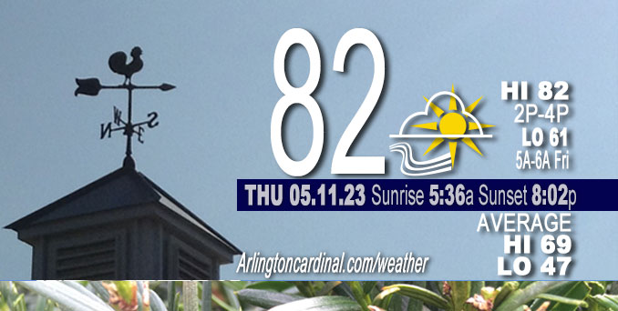
Thursday Hi 82, partly cloudy, winds E to ESE, 3 to 11 to 5 MPH, G14, 12p to 4p
NWS CHGO | NWS HRLY | /NWSchicago | 🌡
ARLINGTON HEIGHTS WEATHER
▴ forecast7 (Arl. Hts.) | RADAR | WIDE RADAR
⏪ Hrly Data Table | Hrly Future Graph ⏩
IMPORTANT NOTE ON NWS DATA
⏪ Hrly Data Table | Hrly Future Graph ⏩
Hello mobile users! If you encounter a mobile “unfriendly” weather page, turn your phone sideways for a better view.
======================
Thursday and Thursday Evening …
No Weather Hazards expected …
Sunny, with a high near 84 around 2:00 p.m. to 4:00 p.m. South southeast wind 5 to 10 mph. Low dewpoint upper 30s to low 40s
DISCUSSION…
A 20+ degree land-lake temperature spread will send a robust lake breeze inland across NE Illinois this afternoon which will continue to hold immediate lakeside locales in the mid 60s. High-level cirrus should gradually diminish through the rest of the morning, yielding mostly sunny conditions across much of the area with any anvil blow off from aforementioned Minnesota convection drifting mostly north of our area. A more expansive plume of mid-level moisture currently pressing into far downstate Illinois will eventually get up here late this afternoon and evening with increasing cloud cover.
======================
O’HARE FORECAST …
Forecast Beginning Thursday, May 11, 2023
Thursday: Sunny, with a high near 84. South southeast wind 5 to 10 mph.
Thursday Night: A 30 percent chance of showers and thunderstorms after 4am. Increasing clouds, with a low around 61. East southeast wind 5 to 10 mph.
Friday: A chance of showers and thunderstorms before 7am, then showers likely and possibly a thunderstorm between 7am and 1pm, then a chance of showers and thunderstorms after 1pm. Cloudy, with a high near 71. East southeast wind 5 to 10 mph, with gusts as high as 15 mph. Chance of precipitation is 70%. New rainfall amounts between a quarter and half of an inch possible.
Friday Night: A chance of showers and thunderstorms before 1am, then a slight chance of showers. Mostly cloudy, with a low around 55. North northeast wind 5 to 10 mph. Chance of precipitation is 30%.
Saturday: A 20 percent chance of showers. Partly sunny, with a high near 72. Northeast wind 5 to 15 mph, with gusts as high as 20 mph.
Saturday Night: A slight chance of showers, then a chance of showers and thunderstorms after 1am. Mostly cloudy, with a low around 55. Chance of precipitation is 30%.
Sunday: A 40 percent chance of showers. Mostly cloudy, with a high near 64.
Sunday Night: Mostly cloudy, with a low around 49.
Monday: Mostly sunny, with a high near 69.
Monday Night: Partly cloudy, with a low around 52.
Tuesday: Mostly sunny, with a high near 73.
Tuesday Night: Mostly clear, with a low around 47.
Wednesday: Sunny, with a high near 67.


CHICAGOWEATHERSTATION.COM

ChicagoWeatherStation.com I O’Hare Normal Temps/Precip I O’Hare Record Temps, Precip, Snow
WunderMap® with Temperature/Wind Data || Google: Arlington Heights Area Temps | US TEMPS
Midwest Cloud Cover with Arlington Heights Weather Forecast
ChicagoWeatherStation.com I O’Hare Normal Temps/Precip I O’Hare Record Temps, Precip, Snow
SUNLIGHT DATA FOR SECURITY, TRAFFIC SAFETY, AND SPORTS
SunCalc.net data with solar azimuth and trajectory, times for dawn, sunrise, solar noon, sunset, dusk …
NIGHT SKY THIS MONTH …
Backyard stargazers get a monthly guide to the northern hemisphere’s skywatching events with “Tonight’s Sky.” Check the night sky objects for this month and past months in the playlist from the Space Telescope Science Institute YouTube channel (Musical track The Far River written by Jonn Serrie, from the album And the Stars Go With You courtesy of New World Music Ltd).
Get updates from The Cardinal ALL NEWS FEEDS on Facebook. Just ‘LIKE’ the ‘Arlington Cardinal Page (become a fan of our page). The updates cover all posts and sub-category posts from The Cardinal — Arlingtoncardinal.com. You can also limit feeds to specific categories. See all of The Cardinal Facebook fan pages at Arlingtoncardinal.com/about/facebook …
Help fund The Cardinal Arlingtoncardinal.com/sponsor
/////////////>
Area Forecast Discussion
National Weather Service Chicago/Romeoville, IL
616 AM CDT Thu May 11 2023
.SHORT TERM… Issued at 311 AM CDT Thu May 11 2023
Through Friday…
Very quiet in the weather department locally. An ongoing compact upwind-propagating MCS across southeast Minnesota may yet build southeastward into a modest LLJ and along the 850 mb theta-e gradient (perhaps even more than hires guidance would suggest), but should eventually yield to diminishing northwesterly shear and instability with eastward extent.
Today looks like a pleasant, summer-like day with temperatures likely taking a 3 to 6 degree jump over where they were yesterday. 925 mb temperature climatology solidly supports widespread low to even mid 80s. A 20+ degree land-lake temperature spread will send a robust lake breeze inland across NE Illinois this afternoon which will continue to hold immediate lakeside locales in the mid 60s. High-level cirrus should gradually diminish through the rest of the morning, yielding mostly sunny conditions across much of the area with any anvil blow off from aforementioned Minnesota convection drifting mostly north of our area. A more expansive plume of mid-level moisture currently pressing into far downstate Illinois will eventually get up here late this afternoon and evening with increasing cloud cover.
With a reservoir of 850 mb dewpoints under -10 C drifting overhead today and likely efficient/strong PBL mixing, once again dropped dewpoints towards the more aggressively-mixing guidance (WRF-ARW in particular with its non-local YSU PBL scheme which seems to do pretty well in regimes like this). This results in afternoon RH values around 20-25 percent. Thankfully, wind gusts will remain under 20 mph today which will curtail an elevated fire danger.
Moisture increases tonight ahead of a lead shortwave with what looks like a convectively-augmented MCV headed north out of the Ark-La-Tex. Very dry low levels ahead of this feature should really chew away at any leading precip shield, and have delayed PoPs a bit with this forecast issuance. Eventually though, a saturating column combined with decent large scale DCVA should result in an expanding area of showers Thursday night and especially into Friday morning. Instability looks scant, but enough of a signal to hold onto some low thunder chances, mainly south of I-80. Through Friday morning, do think we`ll see pretty good precip coverage over most of the area and particularly into far northeast Illinois/northwest Indiana where upper divergence will be maximized.
A surface boundary will become quasistationary through the afternoon. Climatologically, this would be favored to surge south of even I-80 given lake temperatures still in the upper 40s/near 50. To its north, isolated to scattered showers will continue through the afternoon. To its south, instability will modestly increase, although this will be tempered significantly by warmer mid-level temperatures and moist-adiabatic lapse rates. Scattered showers and thunderstorms may re-develop with some muted insolation (won`t take much heating to erode MLCIN in this moistening environment). We continue to monitor this period for a locally heavy rain potential owing to high atmospheric moisture (PWATs nearly 200 percent of normal), slow storm motions (under 10 knots), and a potential for modest “upwind” develop with propagation along the aforementioned quasistationary boundary. Am somewhat uncertain just how extensive afternoon development will be given the departing morning shortwave and overall modest large scale forcing mechanisms, but little MLCIN and a nearby surface boundary suggest at least widely scattered convection is a decent bet. While not a classic setup, weak shear, steepening 0-1 km lapse rates, and high moisture suggest a potential for some tropical-like funnels near the surface boundary.
Friday`s high temperatures will be quite a bit cooler across northern Illinois (low 70s inland and near 60 at the lakefront), while some muted insolation/heating should allow mid and upper 70 degree readings to materialize farther south.
Carlaw/NWS Chicago
