
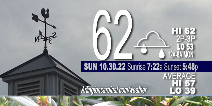
SUNDAY Hi 62°F, mostly cloudy, chance showers, winds ESE to NE, 3 to 6 MPH
NWS CHGO | NWS HRLY | /NWSchicago | 🌡
ARLINGTON HEIGHTS WEATHER
▴ forecast7 (Arl. Hts.) | RADAR | WIDE RADAR
⏪ Hrly Data Table | Hrly Future Graph ⏩
IMPORTANT NOTE ON NWS DATA
⏪ Hrly Data Table | Hrly Future Graph ⏩
======================
No watches or warnings issued near O’Hare at 6:00 a.m. Sunday.
Updates at Arlingtoncardinal.com/NWSChicago
Sunday and early Sunday Night.
No weather hazards expected…
Scattered showers possible. Significant fog risk Monday morning
Hello mobile users! If you encounter mobile “unfriendly” weather page, turn your phone sideways for a better view.
======================
O’HARE FORECAST …
Forecast Beginning Sunday, Oct. 30, 2022
Sunday Afternoon Isolated showers after 3pm. Cloudy, with a high near 62. East northeast wind around 5 mph. Chance of precipitation is 20%.
Sunday Night Scattered showers. Cloudy, with a low around 50. North northeast wind around 5 mph. Chance of precipitation is 50%.
Monday A 30 percent chance of showers, mainly before 10am. Mostly cloudy, with a high near 60. North northeast wind around 5 mph, with gusts as high as 10 mph.
Monday Night Mostly cloudy, then gradually becoming mostly clear, with a low around 44. North wind around 5 mph becoming calm in the evening.
Tuesday Sunny, with a high near 67. Calm wind becoming west southwest around 5 mph in the morning. Winds could gust as high as 10 mph.
Tuesday Night Mostly clear, with a low around 45.
Wednesday Sunny, with a high near 69.
Wednesday Night Partly cloudy, with a low around 52.
Thursday Mostly sunny, with a high near 70.
Thursday Night A chance of showers after 1am. Mostly cloudy, with a low around 57.
Friday A chance of showers. Mostly cloudy, with a high near 65.
Friday Night A chance of showers. Mostly cloudy, with a low around 53.
Saturday A chance of showers. Mostly cloudy, with a high near 62.


CHICAGOWEATHERSTATION.COM

ChicagoWeatherStation.com I O’Hare Normal Temps/Precip I O’Hare Record Temps, Precip, Snow
LIVE RADAR | STORM TRACKS | UNISYS US IR SAT | UNISYS Midwest IR SAT | UNISYS More IR SAT
WunderMap® with Temperature/Wind Data || Google: Arlington Heights Area Temps | US TEMPS
Full Screen Motion Weather Radar (Wunderground.com)
Midwest Cloud Cover with Arlington Heights Weather Forecast
ChicagoWeatherStation.com I O’Hare Normal Temps/Precip I O’Hare Record Temps, Precip, Snow
SUNLIGHT DATA FOR SECURITY, TRAFFIC SAFETY, AND SPORTS
SunCalc.net data with solar azimuth and trajectory, times for dawn, sunrise, solar noon, sunset, dusk …
NIGHT SKY THIS MONTH …
Backyard stargazers get a monthly guide to the northern hemisphere’s skywatching events with “Tonight’s Sky.” Check the night sky objects for this month and past months in the playlist from the Space Telescope Science Institute YouTube channel (Musical track The Far River written by Jonn Serrie, from the album And the Stars Go With You courtesy of New World Music Ltd).
Get updates from The Cardinal ALL NEWS FEEDS on Facebook. Just ‘LIKE’ the ‘Arlington Cardinal Page (become a fan of our page). The updates cover all posts and sub-category posts from The Cardinal — Arlingtoncardinal.com. You can also limit feeds to specific categories. See all of The Cardinal Facebook fan pages at Arlingtoncardinal.com/about/facebook …
Help fund The Cardinal Arlingtoncardinal.com/sponsor
Area Forecast Discussion
National Weather Service Chicago/Romeoville, IL
620 AM CDT Sun Oct 30 2022
.SHORT TERM…
Issued at 315 AM CDT Sun Oct 30 2022
Through Monday…
Focus in the short term is on the potential for showers this afternoon into Monday. Unfortunate timing for the Halloween weekend but it doesn`t look like a wash out either, with occasional breaks in between rounds of scattered showers, especially on Monday.
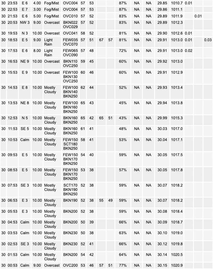
Early this morning high clouds have expanded across the area in advance of an approaching closed upper low currently over northern Arkansas/southern Missouri. This system will gradually lift northeast toward the area through the day today. An initial outer band of vorticity moves overhead mid to late morning. Low- levels appear too dry for any precipitation to reach the ground as it moves overhead, likely no more than virga or a stray sprinkle, and have kept the forecast dry accordingly through the morning hours. Heading into the afternoon shower chances increase from south to north as showers begin to lift out of central Illinois as they wrap around the northeast side of the surface low through the evening. With a slightly slower movement of the system and well above normal PWATs lifting into the area, rainfall amounts have been increased slightly for areas along and south of I-80 with localized amounts over a half inch possible in spots that end u Pseeing multiple rounds of showers.
The initial upper low will weaken and lift to the northeast more quickly than the surface low with a brief break in the mid to upper level support prior to sunrise early Halloween morning. A secondary mid-upper wave will quickly follow suite and move overhead late Monday morning through the afternoon and the initial surface low now passing through the area. Simulated reflectivity during the day on Monday suggests that shower coverage will be on the lower side – isolated to widely scattered. The greatest chance for greater coverage currently looks to reside mainly southeast of Interstate-55 which will be closer to the center of the surface low track.
Temperatures today and Monday will be slightly cooler than Saturday in the lower 60s thanks to the increased cloud cover and showers being around limiting some of our daytime heating. Lows tonight remain on the warmer side, cooling into the upper 40s to lower 50s.
Petr/NWS Chicago
