
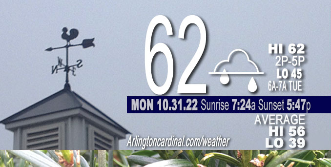
MONDAY Hi 62°F, Dense Fog Advisory east of I-55, chance showers, mostly cloudy clearing after 5p, winds NE to NNE to NW to W, 2 to 6 to 5 MPH
NWS CHGO | NWS HRLY | /NWSchicago | 🌡
ARLINGTON HEIGHTS WEATHER
▴ forecast7 (Arl. Hts.) | RADAR | WIDE RADAR
⏪ Hrly Data Table | Hrly Future Graph ⏩
IMPORTANT NOTE ON NWS DATA
⏪ Hrly Data Table | Hrly Future Graph ⏩
======================
No watches or warnings issued near O’Hare at 6:00 a.m. Monday.
Updates at Arlingtoncardinal.com/NWSChicago
No weather hazards expected…
Scattered showers possible. Significant fog risk Monday morning
Hello mobile users! If you encounter mobile “unfriendly” weather page, turn your phone sideways for a better view.
======================
O’HARE FORECAST …
Forecast Beginning Monday, Oct. 31, 2022
Monday A 30 percent chance of showers, mainly before 10am. Mostly cloudy, with a high near 60. North northeast wind around 5 mph, with gusts as high as 10 mph.
Monday Night Mostly cloudy, then gradually becoming mostly clear, with a low around 44. North wind around 5 mph becoming calm in the evening.
Tuesday Sunny, with a high near 67. Calm wind becoming west southwest around 5 mph in the morning. Winds could gust as high as 10 mph.
Tuesday Night Mostly clear, with a low around 45.
Wednesday Sunny, with a high near 69.
Wednesday Night Partly cloudy, with a low around 52.
Thursday Mostly sunny, with a high near 70.
Thursday Night A chance of showers after 1am. Mostly cloudy, with a low around 57.
Friday A chance of showers. Mostly cloudy, with a high near 65.
Friday Night A chance of showers. Mostly cloudy, with a low around 53.
Saturday A chance of showers. Mostly cloudy, with a high near 62.


CHICAGOWEATHERSTATION.COM

ChicagoWeatherStation.com I O’Hare Normal Temps/Precip I O’Hare Record Temps, Precip, Snow
LIVE RADAR | STORM TRACKS | UNISYS US IR SAT | UNISYS Midwest IR SAT | UNISYS More IR SAT
WunderMap® with Temperature/Wind Data || Google: Arlington Heights Area Temps | US TEMPS
Full Screen Motion Weather Radar (Wunderground.com)
Midwest Cloud Cover with Arlington Heights Weather Forecast
ChicagoWeatherStation.com I O’Hare Normal Temps/Precip I O’Hare Record Temps, Precip, Snow
SUNLIGHT DATA FOR SECURITY, TRAFFIC SAFETY, AND SPORTS
SunCalc.net data with solar azimuth and trajectory, times for dawn, sunrise, solar noon, sunset, dusk …
NIGHT SKY THIS MONTH …
Backyard stargazers get a monthly guide to the northern hemisphere’s skywatching events with “Tonight’s Sky.” Check the night sky objects for this month and past months in the playlist from the Space Telescope Science Institute YouTube channel (Musical track The Far River written by Jonn Serrie, from the album And the Stars Go With You courtesy of New World Music Ltd).
Get updates from The Cardinal ALL NEWS FEEDS on Facebook. Just ‘LIKE’ the ‘Arlington Cardinal Page (become a fan of our page). The updates cover all posts and sub-category posts from The Cardinal — Arlingtoncardinal.com. You can also limit feeds to specific categories. See all of The Cardinal Facebook fan pages at Arlingtoncardinal.com/about/facebook …
Help fund The Cardinal Arlingtoncardinal.com/sponsor
Area Forecast Discussion
National Weather Service Chicago/Romeoville, IL
620 AM CDT Sun Oct 30 2022
.SHORT TERM…
Issued at 315 AM CDT Sun Oct 30 2022
Through Monday…
Focus in the short term is on the potential for showers this afternoon into Monday. Unfortunate timing for the Halloween weekend but it doesn`t look like a wash out either, with occasional breaks in between rounds of scattered showers, especially on Monday.
Early this morning high clouds have expanded across the area in advance of an approaching closed upper low currently over northern Arkansas/southern Missouri. This system will gradually lift northeast toward the area through the day today. An initial outer band of vorticity moves overhead mid to late morning. Low- levels appear too dry for any precipitation to reach the ground as it moves overhead, likely no more than virga or a stray sprinkle, and have kept the forecast dry accordingly through the morning hours. Heading into the afternoon shower chances increase from south to north as showers begin to lift out of central Illinois as they wrap around the northeast side of the surface low through the evening. With a slightly slower movement of the system and well above normal PWATs lifting into the area, rainfall amounts have been increased slightly for areas along and south of I-80 with localized amounts over a half inch possible in spots that end u Pseeing multiple rounds of showers.
The initial upper low will weaken and lift to the northeast more quickly than the surface low with a brief break in the mid to upper level support prior to sunrise early Halloween morning. A secondary mid-upper wave will quickly follow suite and move overhead late Monday morning through the afternoon and the initial surface low now passing through the area. Simulated reflectivity during the day on Monday suggests that shower coverage will be on the lower side – isolated to widely scattered. The greatest chance for greater coverage currently looks to reside mainly southeast of Interstate-55 which will be closer to the center of the surface low track.
Temperatures today and Monday will be slightly cooler than Saturday in the lower 60s thanks to the increased cloud cover and showers being around limiting some of our daytime heating. Lows tonight remain on the warmer side, cooling into the upper 40s to lower 50s.
Petr/NWS ChicagoNWS CHGO | NWS HRLY | /NWSchicago | 🌡
ARLINGTON HEIGHTS WEATHER
▴ forecast7 (Arl. Hts.) | RADAR | WIDE RADAR
⏪ Hrly Data Table | Hrly Future Graph ⏩
IMPORTANT NOTE ON NWS DATA
⏪ Hrly Data Table | Hrly Future Graph ⏩
======================
Dense Fog Advisory includes O’Hare but not Arlington Heights
No watches or warnings issued near O’Hare at 6:00 a.m. Monday.
Updates at Arlingtoncardinal.com/NWSChicago
Monday and early Monday night.
Weather hazards expected…
Significant fog risk Monday morning, especially east of a line from Chicago to Aurora to Ottawa, Illinois.
Hello mobile users! If you encounter mobile “unfriendly” weather page, turn your phone sideways for a better view.
======================
Dense Fog Advisory
URGENT – WEATHER MESSAGE
National Weather Service Chicago IL
307 AM CDT Mon Oct 31 2022
Grundy-Kankakee-Livingston-Iroquois-Ford-Central Cook-Southern Cook-Northern Will-Southern Will-Eastern Will-Lake IN-Porter-Newton-Jasper-Benton-
Including the cities of Morris, Coal City, Minooka, Kankakee, Bourbonnais, Bradley, Pontiac, Dwight, Fairbury, Watseka, Gilman, Paxton, Gibson City, Chicago, Cicero, Oak Lawn, Oak Park, La Grange, Calumet City, Oak Forest, Lemont, Orland Park, Park Forest, Joliet, Bolingbrook, Plainfield, Mokena, Channahon, Manhattan, Wilmington, Crete, Peotone, Beecher, Gary, Hammond, Merrillville, Portage, Valparaiso, Chesterton, Roselawn, Kentland, Morocco, Rensselaer, DeMotte, Fowler, and Oxford
307 AM CDT Mon Oct 31 2022 /407 AM EDT Mon Oct 31 2022
…DENSE FOG ADVISORY IN EFFECT UNTIL 10 AM CDT THIS MORNING…
* WHAT…Visibility less than one mile in dense fog.
* WHERE…Portions of central, east central and northeast Illinois and northwest Indiana.
* WHEN…Until 10 AM CDT this morning.
* IMPACTS…Hazardous driving conditions due to low visibility.
PRECAUTIONARY/PREPAREDNESS ACTIONS…
If driving, slow down, use your headlights, and leave plenty of distance ahead of you.
======================
Hazardous Weather Outlook
National Weather Service Chicago/Romeoville IL
415 AM CDT Mon Oct 31 2022
Winnebago-Boone-McHenry-Lake IL-Ogle-Lee-De Kalb-Kane-DuPage-La Salle-Kendall-Grundy-Kankakee-Livingston-Iroquois-Ford-Northern Cook-Central Cook-Southern Cook-Northern Will-Southern Will-Eastern Will-Lake IN-Porter-Newton-Jasper-Benton-
415 AM CDT Mon Oct 31 2022 /515 AM EDT Mon Oct 31 2022
This Hazardous Weather Outlook is for portions of North Central Illinois…Northeast Illinois and Northwest Indiana.
Monday and Monday Night
Weather hazards expected…
Significant Fog Risk this morning.
DISCUSSION…
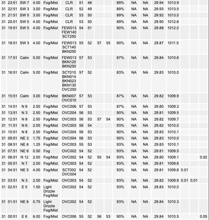
Widespread drizzle and fog has developed along and east of the Interstate 55 corridor early this morning. Widespread visibilities of less than a mile can be expected from Chicago south through east central Illinois and east into northwest Indiana. Fog may persist into mid-morning before improving.
O’HARE FORECAST …
Forecast Beginning Monday, Oct. 31, 2022
Early Monday Morning: A slight chance of drizzle. Areas of dense fog. Otherwise, cloudy, with a low around 52. Calm wind.
Monday: A slight chance of drizzle before 11am, then a chance of showers, mainly between 11am and 4pm. Areas of dense fog before 11am. Otherwise, cloudy, with a high near 62. Calm wind becoming north around 5 mph in the afternoon. Chance of precipitation is 30%.
Monday Night: Mostly cloudy, then gradually becoming mostly clear, with a low around 45. West wind around 5 mph.
Tuesday: Sunny, with a high near 67. West southwest wind around 5 mph, with gusts as high as 10 mph.
Tuesday Night: Mostly clear, with a low around 44. South southwest wind around 5 mph.
Wednesday: Sunny, with a high near 69.
Wednesday Night: Partly cloudy, with a low around 52.
Thursday: Partly sunny, with a high near 70.
Thursday Night: Mostly cloudy, with a low around 57.
Friday: A chance of showers. Cloudy, with a high near 67.
Friday Night: A chance of showers. Cloudy, with a low around 52.
Saturday: A chance of showers. Mostly cloudy, with a high near 60.
Saturday Night: A chance of showers. Mostly cloudy, with a low around 51.
Sunday: A chance of showers. Partly sunny, with a high near 62.
CHICAGOWEATHERSTATION.COM
ChicagoWeatherStation.com I O’Hare Normal Temps/Precip I O’Hare Record Temps, Precip, Snow
LIVE RADAR | STORM TRACKS | UNISYS US IR SAT | UNISYS Midwest IR SAT | UNISYS More IR SAT
WunderMap® with Temperature/Wind Data || Google: Arlington Heights Area Temps | US TEMPS
Full Screen Motion Weather Radar (Wunderground.com)
Midwest Cloud Cover with Arlington Heights Weather Forecast
ChicagoWeatherStation.com I O’Hare Normal Temps/Precip I O’Hare Record Temps, Precip, Snow
SUNLIGHT DATA FOR SECURITY, TRAFFIC SAFETY, AND SPORTS
SunCalc.net data with solar azimuth and trajectory, times for dawn, sunrise, solar noon, sunset, dusk …
NIGHT SKY THIS MONTH …
Backyard stargazers get a monthly guide to the northern hemisphere’s skywatching events with “Tonight’s Sky.” Check the night sky objects for this month and past months in the playlist from the Space Telescope Science Institute YouTube channel (Musical track The Far River written by Jonn Serrie, from the album And the Stars Go With You courtesy of New World Music Ltd).
Get updates from The Cardinal ALL NEWS FEEDS on Facebook. Just ‘LIKE’ the ‘Arlington Cardinal Page (become a fan of our page). The updates cover all posts and sub-category posts from The Cardinal — Arlingtoncardinal.com. You can also limit feeds to specific categories. See all of The Cardinal Facebook fan pages at Arlingtoncardinal.com/about/facebook …
Help fund The Cardinal Arlingtoncardinal.com/sponsor
Area Forecast Discussion
National Weather Service Chicago/Romeoville, IL
653 AM CDT Mon Oct 31 2022
.SHORT TERM…
Issued at 337 AM CDT Mon Oct 31 2022
Through Tuesday…
Near term focus is on areas of dense fog and drizzle generally along and east of the I-55 corridor early this morning. A dense fog advisory has been issued for this area until 10 am. Showers will also increase from the south this morning, with rain expected mainly southeast of about a Peru IL to Chicago line. Showers will eventually diminish in coverage and intensity and move east of the IL/IN border by evening, and ending thereafter.
Early morning surface analysis indicates low pressure of roughly 1010 mb centered south of Springfield IL. A very moist low level air mass was in place within the warm sector of this system, characterized by surface dew points in the mid-upper 50s. Combined with light convergent wind field and earlier light rain associated with a lead mid-level vort currently lifting into lower Michigan, this has set the stage for a fairly expansive area of fog across much of eastern IL and northwest IN. Surface obs indicate plenty of 1/4SM to 1/2SM visibilities along and east of the I-55 corridor as of 08Z, and have issued a dense fog advisory for this area this morning. Conditions are not likely to improve much until showers expand and spread into the area later this morning, in association with a second mid-level short wave currently seen in water vapor imagery over Missouri. Northwest of about a Peru IL to Chicago line, fog, drizzle and showers will be much more spotty.
With a warm/humid start to the morning, temps should gradually warm to around 60 degrees across the foggy/cloudy/showery southeast half of the forecast area. Farther northwest, temps may reach the mid 60s later this afternoon especially if appreciable clearing occurs before late afternoon. With the second mid-level short wave moving east-northeast of the area this evening, clearing is expected over much of the area. Redevelopment of fog appears possible overnight across the southeast part of the forecast area again, where moist ground will not have the chance to dry out without clearing this afternoon.
Sunshine returns to the region Tuesday, with short wave mid-level ridge building overhead and modest south-southwest low level winds developing. Temps should reach the mid-60s east and upper 60s west, roughly 10 degrees or more above our average highs for November 1st.
Ratzer/NWS Chicago
