
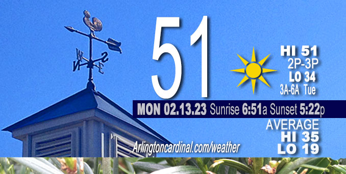
Monday Hi 51, Sunny, winds NW to SW to S, 10 to 14 to 5 to 6 MPH, G16 to 22 to 15 MPH until 3p
NWS CHGO | NWS HRLY | /NWSchicago | 🌡
ARLINGTON HEIGHTS WEATHER
▴ forecast7 (Arl. Hts.) | RADAR | WIDE RADAR
⏪ Hrly Data Table | Hrly Future Graph ⏩
IMPORTANT NOTE ON NWS DATA
⏪ Hrly Data Table | Hrly Future Graph ⏩
======================
Monday and Monday Evening …
No Weather Hazards expected …
Quiet weather continues Monday, with temps perhaps just a few degrees cooler than yesterday after the early morning passage of a weak cold front (ranging from the upper 40s far northwest to the low-mid 50s south). Focus then shifts to the later Tuesday afternoon and Tuesday night when a storm system is forecast to bring strong winds of 35-40+ mph, showers and perhaps a few embedded thunderstorms.
DISCUSSION…
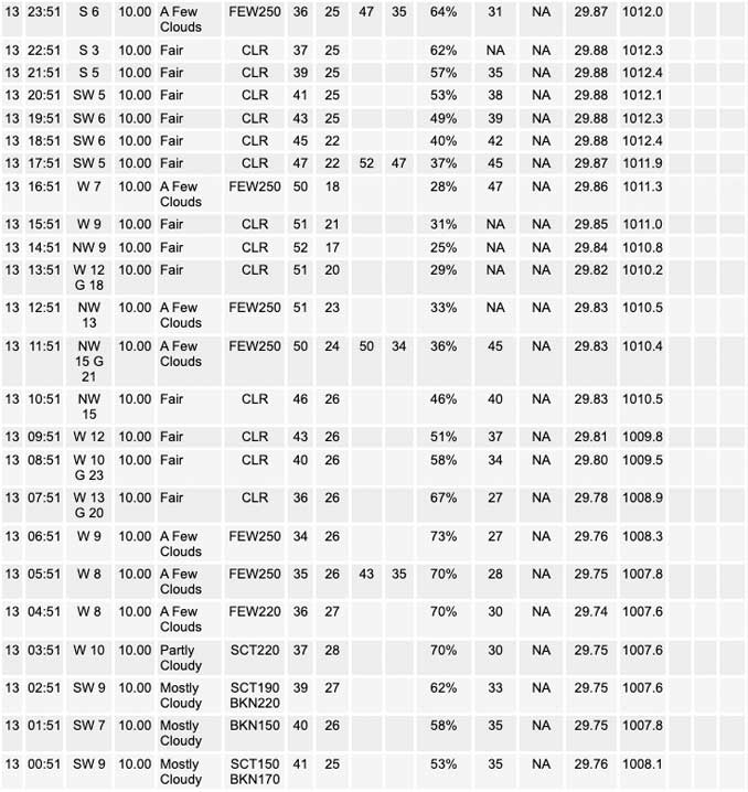
Almost full sunshine can be expected across the region Monday after sunrise. We’ve been partly cloudy after a mostly cloudy night since about 3:45 a.m. Early morning surface analysis depicts 1002 mb low pressure moving east across Lake Superior, trailing a weak cold front through northern Illinois, Missouri and into the southern Plains. Only notable weather this morning, besides the actual cold frontal wind shift, is an area of mid and high clouds working east across the forecast area. These clouds should clear Chicagoland by sunrise per extrapolation from satellite. Northwest winds become modestly breezy for a time after sunrise Monday morning, but otherwise today looks to have a continuation of sunny skies and above average mid-February warmth. Decreasing northwest winds this afternoon even look to support a weak lake breeze into northwest Indiana. Surface high pressure ridge slides across the area this evening, with light winds and clear skies allowing temps to drop into the low-mid 30s. Warm advection develops aloft overnight as the ridge moves off to the east, allowing some increasing high cirrus from the south toward morning.
Daily low temperatures and daily high temperatures are on the way up. We’re gaining about 2 minutes of daylight every day in the progression toward vernal equinox, March 20, 2023.
======================
O’HARE FORECAST …
Forecast Beginning Monday, Feb. 13, 2023
Monday: Sunny, with a high near 51. Northwest wind 10 to 15 mph, with gusts as high as 25 mph.
Monday Night: Mostly clear, with a low around 34. West wind around 5 mph becoming south after midnight. Winds could gust as high as 15 mph.
Tuesday: Showers likely after 1pm. Increasing clouds, with a high near 52. Breezy, with a south wind 5 to 10 mph increasing to 15 to 20 mph in the afternoon. Winds could gust as high as 35 mph. Chance of precipitation is 60%. New precipitation amounts of less than a tenth of an inch possible.
Tuesday Night: Showers, mainly before 1am. Low around 45. Breezy, with a south southwest wind around 25 mph, with gusts as high as 40 mph. Chance of precipitation is 80%.
Wednesday: A 20 percent chance of showers before 7am. Partly sunny, with a high near 51. Windy, with a southwest wind 25 to 30 mph decreasing to 15 to 20 mph in the afternoon. Winds could gust as high as 40 mph.
Wednesday Night: A chance of rain and snow after 1am. Mostly cloudy, with a low around 32. Chance of precipitation is 30%.
Thursday: Snow likely, possibly mixed with rain, mainly after 7am. Mostly cloudy, with a high near 36. Breezy. Chance of precipitation is 60%.
Thursday Night: Snow likely before 7pm. Mostly cloudy, with a low around 16. Blustery.
Friday: Mostly sunny, with a high near 27.
Friday Night: Mostly clear, with a low around 21.
Saturday: Sunny, with a high near 44. Breezy.
Saturday Night: Partly cloudy, with a low around 35. Breezy.
Sunday: Mostly sunny, with a high near 49.


CHICAGOWEATHERSTATION.COM

ChicagoWeatherStation.com I O’Hare Normal Temps/Precip I O’Hare Record Temps, Precip, Snow
LIVE RADAR | STORM TRACKS | UNISYS US IR SAT | UNISYS Midwest IR SAT | UNISYS More IR SAT
WunderMap® with Temperature/Wind Data || Google: Arlington Heights Area Temps | US TEMPS
Full Screen Motion Weather Radar (Wunderground.com)
Midwest Cloud Cover with Arlington Heights Weather Forecast
ChicagoWeatherStation.com I O’Hare Normal Temps/Precip I O’Hare Record Temps, Precip, Snow
SUNLIGHT DATA FOR SECURITY, TRAFFIC SAFETY, AND SPORTS
SunCalc.net data with solar azimuth and trajectory, times for dawn, sunrise, solar noon, sunset, dusk …
NIGHT SKY THIS MONTH …
Backyard stargazers get a monthly guide to the northern hemisphere’s skywatching events with “Tonight’s Sky.” Check the night sky objects for this month and past months in the playlist from the Space Telescope Science Institute YouTube channel (Musical track The Far River written by Jonn Serrie, from the album And the Stars Go With You courtesy of New World Music Ltd).
Get updates from The Cardinal ALL NEWS FEEDS on Facebook. Just ‘LIKE’ the ‘Arlington Cardinal Page (become a fan of our page). The updates cover all posts and sub-category posts from The Cardinal — Arlingtoncardinal.com. You can also limit feeds to specific categories. See all of The Cardinal Facebook fan pages at Arlingtoncardinal.com/about/facebook …
Help fund The Cardinal Arlingtoncardinal.com/sponsor
Area Forecast Discussion
National Weather Service Chicago/Romeoville, IL
554 AM CST Mon Feb 13 2023
.SHORT TERM… Issued at 314 AM CST Mon Feb 13 2023
Through Tuesday night…
Quiet weather continues today, with temps perhaps just a few degrees cooler than yesterday after the early morning passage of a weak cold front. Focus then shifts to the later Tuesday afternoon/night period as a storm system brings strong winds of 35-40+ mph, showers and perhaps a few embedded thunder storms.
Early morning surface analysis depicts 1002 mb low pressure moving east across Lake Superior, trailing a weak cold front through northern IL, MO and into the southern Plains. Aloft, GOES water vapor imagery indicated a fairly decent mid-level short wave propagating eastward across the upper Midwest. Only notable weather this morning, besides the actual cold frontal wind shift, is an area of mid and high clouds working east across the forecast area. These clouds should clear the cwa by sunrise per extrapolation from satellite. May see northwest winds become modestly breezy for a time after sunrise this morning, but otherwise today looks to have a continuation of sunny skies and above average mid-February warmth. Temps will be perhaps just a couple degrees cooler than yesterday with highs expected to range from the upper 40s far northwest to the low-mid 50s south. Decreasing northwest winds this afternoon even look to support a weak lake breeze into northwest IN. Surface high pressure ridge slides across the area this evening, with light winds and clear skies allowing temps to drop into the low-mid 30s. Warm advection develops aloft overnight as the ridge moves off to the east, allowing some increasing high cirrus from the south toward morning.
Looking well to the southwest in the GOES vapor imagery this morning, an upper level low was evident along the California/Baja border. As guidance has consistently shown over the past several days, this wave is progged to lift northeast across the Plains Tuesday and move to the upper Midwest/northern Great Lakes region Wednesday morning. Sub-990 mb surface low pressure will move into the mid-Missouri Valley along the Nebraska/Iowa border by Tuesday evening, tightening the surface pressure gradient eastward across the Midwest in response to strong (4-6 mb 3 hour) pressure falls during the afternoon. This in turn results in increasing southeast winds across the forecast area, eventually producing 35-40 mph and a few sporadic stronger wind gusts across the area Tuesday night. Rain showers will also spread northeast across the forecast area Tuesday afternoon, with the greatest coverage expected Tuesday evening ahead of the occluding warm/cold fronts associated with the low passing to our northwest. There may even be some isolated embedded elevated thunderstorms roughly northwest of the I-55 corridor in northern IL Tuesday evening in a region of stee Pmid- level lapse rates and strong forcing associated with the negatively tilted mid-level wave, divergent left exit region of the upper level jet and a 60 kt southwesterly low level jet. Showers will then taper off from southwest to northeast after midnight as dry air wraps into the departing system from the west.
Ratzer/NWS Chicago
