
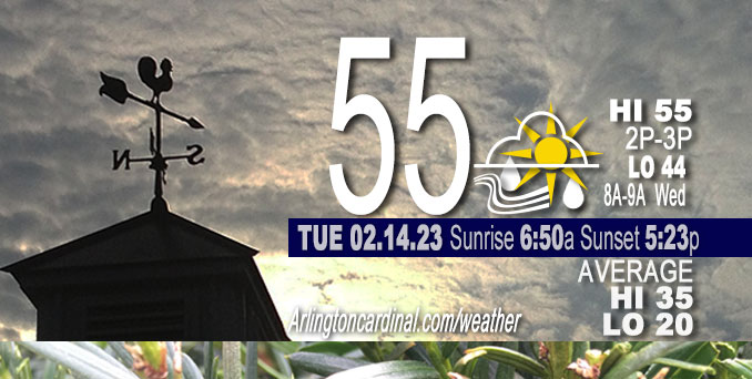
Tuesday Hi 55, light rain likely after 4p, partly sunny to mostly cloudy, winds SSE to SE to SW, 15 to 22 to 17 MPH, G29 to 37 to 33 MPH rising through Wednesday am
NWS CHGO | NWS HRLY | /NWSchicago | 🌡
ARLINGTON HEIGHTS WEATHER
▴ forecast7 (Arl. Hts.) | RADAR | WIDE RADAR
⏪ Hrly Data Table | Hrly Future Graph ⏩
IMPORTANT NOTE ON NWS DATA
⏪ Hrly Data Table | Hrly Future Graph ⏩
======================
Tuesday and Tuesday Evening …
Weather Hazards expected …
Elevated Non Thunderstorm Wind Risk.
Prepare for a cooler Wednesday, and freezing temperatures Thursday and Friday.
DISCUSSION…
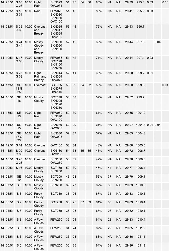
Southeast winds will increase Tuesday, with gusts of 35 to 40 mph possible by late afternoon and early evening. Peak gusts are forecast to occur between 8:00 p.m. Tuesday and 12:00 p.m. Wednesday. Stronger winds with gusts to 45 mph are likely later tonight, especially along and south of the I-80 corridor where a Wind Advisory is in effect from midnight Tuesday night through noon Wednesday. Peak winds near Arlington Heights are likely to reach 40 mph to 43 mph around 5:30 a.m. to 9:00 a.m. Wednesday.
Daily low temperatures and daily high temperatures are on the way up. We’re gaining about 2 minutes of daylight every day in the progression toward vernal equinox, March 20, 2023.
======================
O’HARE FORECAST …
Forecast Beginning Tuesday, Feb. 14, 2023
Tuesday: Showers likely, mainly after 5pm. Cloudy, with a high near 57. Breezy, with a south southeast wind 15 to 20 mph, with gusts as high as 30 mph. Chance of precipitation is 60%. New precipitation amounts of less than a tenth of an inch possible.
Tuesday Night: Showers, mainly before 1am. Low around 44. Breezy, with a south southeast wind 15 to 20 mph becoming southwest after midnight. Winds could gust as high as 40 mph. Chance of precipitation is 100%. New precipitation amounts between a tenth and quarter of an inch possible.
Wednesday: Partly sunny, with a temperature falling to around 44 by 8am. Breezy, with a west southwest wind 20 to 25 mph decreasing to 15 to 20 mph in the afternoon. Winds could gust as high as 45 mph.
Wednesday Night: A 20 percent chance of rain after midnight. Mostly cloudy, with a low around 32. Northwest wind 5 to 10 mph becoming northeast 10 to 15 mph after midnight. Winds could gust as high as 25 mph.
Thursday: Snow likely, possibly mixed with rain and sleet, becoming all snow after 3pm. Cloudy, with a high near 37. Breezy, with a north northeast wind 20 to 25 mph, with gusts as high as 40 mph. Chance of precipitation is 70%.
Thursday Night: A 30 percent chance of snow before midnight. Mostly cloudy, with a low around 15. Blustery.
Friday: Sunny, with a high near 27.
Friday Night: Clear, with a low around 20.
Saturday: Mostly sunny, with a high near 45. Breezy.
Saturday Night: Mostly cloudy, with a low around 34.
Sunday: Partly sunny, with a high near 47.
Sunday Night: Mostly cloudy, with a low around 34.
Monday Washington’s Birthday: Partly sunny, with a high near 47.


CHICAGOWEATHERSTATION.COM

ChicagoWeatherStation.com I O’Hare Normal Temps/Precip I O’Hare Record Temps, Precip, Snow
LIVE RADAR | STORM TRACKS | UNISYS US IR SAT | UNISYS Midwest IR SAT | UNISYS More IR SAT
WunderMap® with Temperature/Wind Data || Google: Arlington Heights Area Temps | US TEMPS
Full Screen Motion Weather Radar (Wunderground.com)
Midwest Cloud Cover with Arlington Heights Weather Forecast
ChicagoWeatherStation.com I O’Hare Normal Temps/Precip I O’Hare Record Temps, Precip, Snow
SUNLIGHT DATA FOR SECURITY, TRAFFIC SAFETY, AND SPORTS
SunCalc.net data with solar azimuth and trajectory, times for dawn, sunrise, solar noon, sunset, dusk …
NIGHT SKY THIS MONTH …
Backyard stargazers get a monthly guide to the northern hemisphere’s skywatching events with “Tonight’s Sky.” Check the night sky objects for this month and past months in the playlist from the Space Telescope Science Institute YouTube channel (Musical track The Far River written by Jonn Serrie, from the album And the Stars Go With You courtesy of New World Music Ltd).
Get updates from The Cardinal ALL NEWS FEEDS on Facebook. Just ‘LIKE’ the ‘Arlington Cardinal Page (become a fan of our page). The updates cover all posts and sub-category posts from The Cardinal — Arlingtoncardinal.com. You can also limit feeds to specific categories. See all of The Cardinal Facebook fan pages at Arlingtoncardinal.com/about/facebook …
Help fund The Cardinal Arlingtoncardinal.com/sponsor
Area Forecast Discussion
National Weather Service Chicago/Romeoville, IL
620 AM CST Tue Feb 14 2023
.SHORT TERM… Issued at 340 AM CST Tue Feb 14 2023
Through Wednesday…
Forecast Highlights…
* Wind advisory in effect from midnight tonight through noon Wednesday generally along and south of the I-80 corridor. Sporadic gusts near advisory criteria possible late afternoon/evening.
* Scattered showers develop this afternoon, with a period of more widespread rain this evening into the early overnight hours. A few rumbles of thunder can`t be ruled out especially northwest of the I-55 corridor tonight.
* Gusty west winds gradually diminish Wednesday.
* Temperatures remain well-above mid-February normals.
A deep upper level trough/closed low was centered over northeast New Mexico early this morning. Model guidance remains in excellent agreement in lifting this feature quickly northeast across the Plains today, and across the upper Midwest and western Great Lakes region tonight into early Wednesday. In response, surface trough currently in the lee of the Rockies is progged to consolidate into a deep surface low of around 985 mb by this evening across western Iowa and track across Lake Superior Wednesday morning. Strong surface pressure falls in advance of this low will quickly tighten the gradient across our region through this afternoon, making for increasing south-southeast winds ahead of the low and an approaching occluding frontal system. Forecast soundings depict low level jet winds ramping up into the 60-70 kt range across the forecast area late this afternoon and evening, though relatively stable low levels ahead of the warm front appear likely to limit mixing into these stronger winds late this afternoon and evening and lend somewhat low confidence to widespread wind advisory criteria during that time. While sporadic gusts 40-45 mph are certainly possible, deepening of the mixed layer behind the occluded frontal passage later tonight into Wednesday morning support a higher confidence in more solid/widespread advisory criteria (sustained 30 mph and/or gusts 45 mph or higher) winds from around midnight tonight into Wednesday morning before winds gradually diminish later in the day. Thus have elected to hoist a wind advisory for the south half of the forecast area during this period, though will issue an SPS highlighting the potential for some sporadic higher gusts prior to the start of the advisory this evening.
Aside from the winds, a band of elevated rain showers is expected to develop into the cwa from the west this afternoon, though coverage may initially be limited until this evening when stronger forcing and deeper saturation arrive. However, strong vorticity advection ahead of the negatively-tilted mid-level wave, strong upper level divergence in the left exit region of the upper level jet steak, and strong isentropic upglide within a narrow axis of nearly 1.00 inch p- wats should result in a decent period of widespread shower/rain coverage toward/during early evening. Some embedded thunder also appears possible this evening, as forecast soundings depict some modest elevated MUCAPE of 100+ J/kg within a region of steeper mid- level lapse rates immediately ahead of the mid-level vort and impinging dry slot. This looks most likely northwest of the I-55 corridor across northern IL from mid-evening through about midnight or a little after. Showers should then end from southwest to northeast after midnight, as the dry slot spreads in aloft and the mid-level wave lifts northeast of the area.
Unseasonably mild mid-February weather persists through the period. Highs today are expected to be in the low-mid 50s area wide despite increasing cloud cover and southeast winds, though the onshore component of those winds will keep the immediate Illinois lake shore in the 40s. Lows tonight will remain in the 40s for most areas, and there will be a larger gradient in temperatures Wednesday as the cold front trailing the low edges across part of the area. Highs Wednesday should range from the mid-upper 40s northwest with more cloud cover, to the mid-upper 50s far southeast where more sun is likely.
Ratzer/NWS Chicago
