
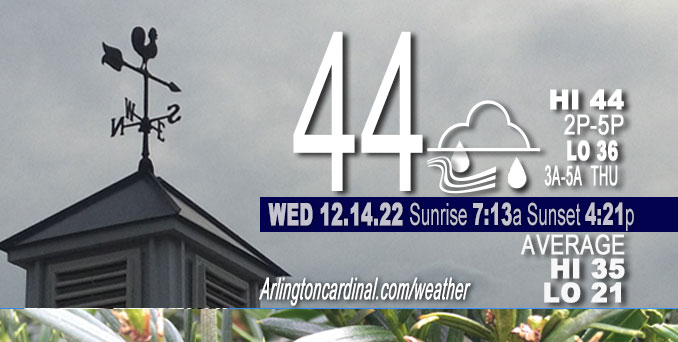
WEDNESDAY Hi 44, cloudy, rain, winds ESE to SE to E, 18 to 20 to 7 MPH, G30 to 31 to 16 MPH until 10p
NWS CHGO | NWS HRLY | /NWSchicago | 🌡
ARLINGTON HEIGHTS WEATHER
▴ forecast7 (Arl. Hts.) | RADAR | WIDE RADAR
⏪ Hrly Data Table | Hrly Future Graph ⏩
IMPORTANT NOTE ON NWS DATA
⏪ Hrly Data Table | Hrly Future Graph ⏩
======================
Wednesday and Wednesday Night …
Weather Hazards expected…
Limited Fog Risk.
Limited Snow Risk north I-90 tonight.
DISCUSSION…
Rain may change over to a period of wet snow after midnight tonight across parts of northern Illinois. While confidence on this remains
low, the potential exists for some minor wet snow accumulation late tonight, primarily north of I-90.
Snow is possible Thursday night and Friday, but currently it only looks like it will accumulate to about 0.6 inch.
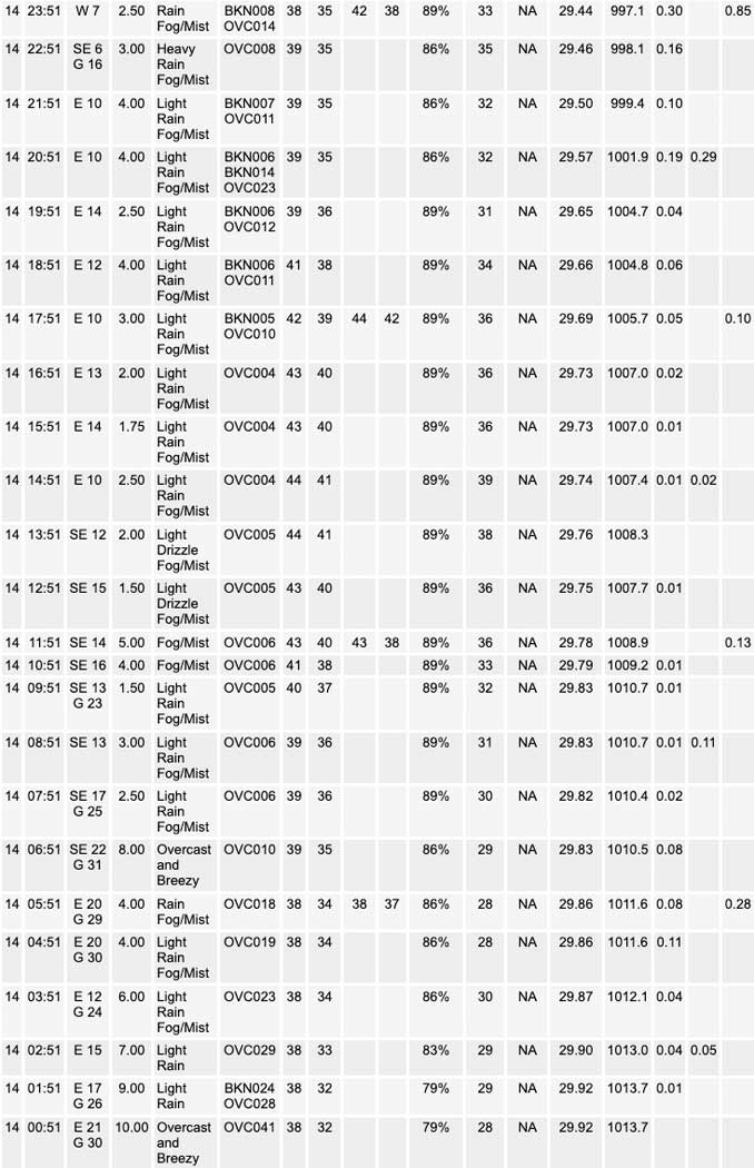
A cold rain, which began about 8 to 9 p.m. Tuesday continues to fall over the region early Wednesday morning as moisture continues to stream northward within the warm conveyor belt of a heavily-occluded low pressure system currently centered over northeastern Nebraska.
Hello mobile users! If you encounter a mobile “unfriendly” weather page, turn your phone sideways for a better view.
======================
O’HARE FORECAST …
Forecast Beginning Wednesday, Dec. 14, 2022
Wednesday: Rain. Patchy fog after 7am. High near 45. Breezy, with an east southeast wind 15 to 20 mph, with gusts as high as 30 mph. Chance of precipitation is 90%. New precipitation amounts between a quarter and half of an inch possible.
Wednesday Night: Rain before 3am, then rain and snow. The rain could be heavy at times. Patchy fog before 4am. Low around 35. East southeast wind 5 to 15 mph becoming west after midnight. Winds could gust as high as 20 mph. Chance of precipitation is 100%. Little or no snow accumulation expected.
Thursday: A slight chance of rain and snow showers before 7am, then a slight chance of snow showers after 1pm. Partly sunny, with a high near 38. South southwest wind 10 to 15 mph, with gusts as high as 25 mph. Chance of precipitation is 20%.
Thursday Night: Snow showers likely, mainly after 7pm. Cloudy, with a low around 29. South southwest wind around 15 mph, with gusts as high as 25 mph. Chance of precipitation is 60%. New snow accumulation of less than one inch possible.
Friday: Snow showers likely, mainly before 7am. Cloudy, with a high near 32. Southwest wind around 15 mph, with gusts as high as 25 mph. Chance of precipitation is 60%.
Friday Night: Scattered snow showers, mainly before 1am. Cloudy, with a low around 24. Chance of precipitation is 50%.
Saturday: Isolated snow showers. Mostly cloudy, with a high near 28. Chance of precipitation is 20%.
Saturday Night: Mostly cloudy, with a low around 20.
Sunday: Partly sunny, with a high near 28.
Sunday Night: Partly cloudy, with a low around 19.
Monday: Partly sunny, with a high near 27.
Monday Night: Mostly cloudy, with a low around 16.
Tuesday: Partly sunny, with a high near 24.


CHICAGOWEATHERSTATION.COM

ChicagoWeatherStation.com I O’Hare Normal Temps/Precip I O’Hare Record Temps, Precip, Snow
LIVE RADAR | STORM TRACKS | UNISYS US IR SAT | UNISYS Midwest IR SAT | UNISYS More IR SAT
WunderMap® with Temperature/Wind Data || Google: Arlington Heights Area Temps | US TEMPS
Full Screen Motion Weather Radar (Wunderground.com)
Midwest Cloud Cover with Arlington Heights Weather Forecast
ChicagoWeatherStation.com I O’Hare Normal Temps/Precip I O’Hare Record Temps, Precip, Snow
SUNLIGHT DATA FOR SECURITY, TRAFFIC SAFETY, AND SPORTS
SunCalc.net data with solar azimuth and trajectory, times for dawn, sunrise, solar noon, sunset, dusk …
NIGHT SKY THIS MONTH …
Backyard stargazers get a monthly guide to the northern hemisphere’s skywatching events with “Tonight’s Sky.” Check the night sky objects for this month and past months in the playlist from the Space Telescope Science Institute YouTube channel (Musical track The Far River written by Jonn Serrie, from the album And the Stars Go With You courtesy of New World Music Ltd).
Get updates from The Cardinal ALL NEWS FEEDS on Facebook. Just ‘LIKE’ the ‘Arlington Cardinal Page (become a fan of our page). The updates cover all posts and sub-category posts from The Cardinal — Arlingtoncardinal.com. You can also limit feeds to specific categories. See all of The Cardinal Facebook fan pages at Arlingtoncardinal.com/about/facebook …
Help fund The Cardinal Arlingtoncardinal.com/sponsor
Area Forecast Discussion
National Weather Service Chicago/Romeoville, IL
543 AM CST Wed Dec 14 2022
.SHORT TERM… Issued at 355 AM CST Wed Dec 14 2022
Through Wednesday night…
Key forecast messages through Wednesday night:
* Steady cold rain continuing through around daybreak to mid-morning with light showers or drizzle lingering around afterwards into the afternoon.
* Secondary wave of cold, soaking rainfall beginning during the late afternoon and continuing into the night, ending prior to daybreak Thursday.
* Increasing likelihood of snow mixing in with rain or becoming the outright precipitation type tonight north of I-90. Minor wet snow accumulations cannot be ruled out, especially near the Illinois-Wisconsin state line.
* Low, but non-zero, chance of advisory-level wind gusts being tagged east of I-55 over a 1-3 hour long period late tonight.
A cold rain continues to fall over the region early this morning as moisture continues to stream northward within the warm conveyor belt of a heavily-occluded low pressure system currently centered over northeastern Nebraska. The steadier rainfall will come to a halt from southwest to northeast between about daybreak and mid-morning as dry mid-level air impinges upon our forecast area, but forecast soundings continue to indicate that a relatively deep saturated layer in the low levels will remain put, and accordingly, isolated to scattered light rain showers and/or drizzle may continue all the way into the afternoon as a few more subtle vort packets charge up into the nose of our resident low-level theta-e plume. Sporadic southeasterly gusts up to around 30 mph also remain possible through the remainder of this morning before the surface pressure gradient relaxes a little in response to the weakening of the occluded low. Despite the ongoing rainfall and widespread stratus encompassing region, warm air advection will cause temperatures to rise in the 40s throughout the CWA today, with even some low 50s readings appearing to be attainable across our southern and western counties.
As we head into the latter half of the afternoon and evening, there`ll be a little bit of deja vu as another widespread cold, soaking rainfall overspreads the region. This rain will blossom along and ahead of an incoming occluded front in response to considerable ascent induced by upper divergence in the left exit region of an upper jet and by a vigorous, quick-moving disturbance that will be yanked northward from Texas by the upper low to our west and thrusted towards the western Great Lakes. Given the strong dynamics in play, the presence of fairly steep lapse rates aloft, and that precipitable water values will still be roughly in the 0.75″ to 1″ range, anticipate that tonight`s rainfall will feature more appreciable rain rates than the rain seen this morning/last night with rain totals likely to end up somewhere between 1″ and 2″ across most of our forecast area (not including any rainfall prior to this afternoon) before a dry slot slides in overhead and ends this precipitation prior to daybreak Thursday. Also can`t rule out a few isolated lightning strikes occurring within this activity with still some signs that a small amount of instability will be present, but just like yesterday, confidence is currently too low in lightning occurring anywhere in our CWA to warrant a formal addition of thunder to the forecast.
Confidence also continues to increase that the strong forcing for ascent will cause thermodynamic profiles to dynamically cool to the point where snow will likely start to mix in with the rain at some point this evening. This is most likely to occur north of I-90, where surface temperatures are expected to drop closer to freezing, and especially as one gets closer to Wisconsin, where snow may become the outright precipitation type for up to a few hours and even accumulate in spite of marginal surface temperatures as a result of the hefty precipitation rates. Dew points remaining elevated should help prevent surface temperatures from falling below freezing, which will, in turn, help mitigate impacts to some extent, but forecast trends will need to continue to be monitored.
Lastly, one final thing to note is that the HRRR and RAP are actually explicitly resolving 45+ mph wind gusts across the eastern third or so of our CWA late tonight for a 1-3 hour long period behind the occluded front. These winds are being generated in response to rapid pressure fluctuations associated with a quickly deepening secondary surface low that both models resolve coming northward through western Indiana and then up across Lake Michigan. Most other guidance either doesn`t develop this secondary low or features a wind response that occurs mainly to our east and/or isn`t as aggressive as what the HRRR and RAP are advertising, but given the magnitude of the large-scale dynamics and kinematics in play tonight, can`t completely discount this solution at this point. That said, confidence is still far too low in this solution verifying to warrant any sort of wind headline issuance at this time. Have trended gusts up across our eastern counties for the late evening/early overnight hours in our going forecast for now, and will let the day shift take a closer look at things and decide if this needs to be more formally messaged at all.
Ogorek/NWS Chicago
