
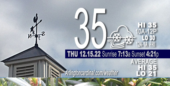
THURSDAY Hi 35, cloudy, light snow, winds SW, 15 to 16 to 13 MPH, G25 to 21 to 22 MPH until through 12a
NWS CHGO | NWS HRLY | /NWSchicago | 🌡
ARLINGTON HEIGHTS WEATHER
▴ forecast7 (Arl. Hts.) | RADAR | WIDE RADAR
⏪ Hrly Data Table | Hrly Future Graph ⏩
IMPORTANT NOTE ON NWS DATA
⏪ Hrly Data Table | Hrly Future Graph ⏩
======================
Thursday and Thursday Night …
Weather Hazards expected…
Limited Snow Risk Thursday and Friday — Gusty Snow Showers.
Limited Excessive Cold Risk Tuesday Dec. 20
Limited Snow Risk Wednesday Dec. 21
DISCUSSION…
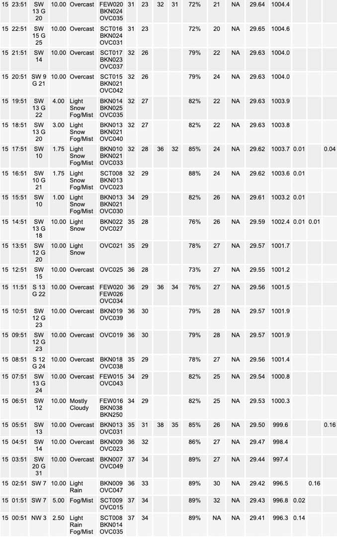
Scattered snow showers are expected to develop across northern Illinois Thursday afternoon and continue at times into Friday. Some of these snow showers could be intense at times, especially late this afternoon and evening, with snow rates resulting in sharp visibility reductions and some minor snow accumulations.
Snow accumulation is not likely on pavement, roads and sidewalks and possibly just a dusting will appear on grass on Thursday. Accumulation is more likely to start on pavement and grass on Friday morning about 6:00 a.m., and light snow is expected to continue through Friday until Saturday about 6:00 p.m. Accumulation for Arlington Heights and nearby communities is expected to be about 0.8 inches at about 6:00 p.m. Saturday.
Hello mobile users! If you encounter a mobile “unfriendly” weather page, turn your phone sideways for a better view.
======================
O’HARE FORECAST …
Forecast Beginning Thursday, Dec. 15, 2022
Thursday: Scattered snow showers, mainly after 2pm. Cloudy, with a high near 36. South southwest wind around 15 mph, with gusts as high as 25 mph. Chance of precipitation is 30%.
Thursday Night: Scattered snow showers. Cloudy, with a low around 30. South southwest wind around 15 mph, with gusts as high as 25 mph. Chance of precipitation is 40%.
Friday: Scattered snow showers. Cloudy, with a high near 31. Southwest wind around 15 mph, with gusts as high as 30 mph. Chance of precipitation is 50%.
Friday Night: Scattered snow showers, mainly before midnight. Mostly cloudy, with a low around 25. West southwest wind around 15 mph, with gusts as high as 25 mph. Chance of precipitation is 30%.
Saturday: Isolated snow showers. Cloudy, with a high near 29. West wind around 15 mph, with gusts as high as 25 mph. Chance of precipitation is 20%.
Saturday Night: Scattered flurries before midnight. Mostly cloudy, with a low around 19.
Sunday: Mostly sunny, with a high near 27.
Sunday Night: Partly cloudy, with a low around 17.
Monday: Partly sunny, with a high near 28.
Monday Night: Mostly cloudy, with a low around 14.
Tuesday: Mostly sunny, with a high near 23.
Tuesday Night: Mostly cloudy, with a low around 12.
Wednesday: A chance of snow. Mostly cloudy, with a high near 27.


CHICAGOWEATHERSTATION.COM

ChicagoWeatherStation.com I O’Hare Normal Temps/Precip I O’Hare Record Temps, Precip, Snow
LIVE RADAR | STORM TRACKS | UNISYS US IR SAT | UNISYS Midwest IR SAT | UNISYS More IR SAT
WunderMap® with Temperature/Wind Data || Google: Arlington Heights Area Temps | US TEMPS
Full Screen Motion Weather Radar (Wunderground.com)
Midwest Cloud Cover with Arlington Heights Weather Forecast
ChicagoWeatherStation.com I O’Hare Normal Temps/Precip I O’Hare Record Temps, Precip, Snow
SUNLIGHT DATA FOR SECURITY, TRAFFIC SAFETY, AND SPORTS
SunCalc.net data with solar azimuth and trajectory, times for dawn, sunrise, solar noon, sunset, dusk …
NIGHT SKY THIS MONTH …
Backyard stargazers get a monthly guide to the northern hemisphere’s skywatching events with “Tonight’s Sky.” Check the night sky objects for this month and past months in the playlist from the Space Telescope Science Institute YouTube channel (Musical track The Far River written by Jonn Serrie, from the album And the Stars Go With You courtesy of New World Music Ltd).
Get updates from The Cardinal ALL NEWS FEEDS on Facebook. Just ‘LIKE’ the ‘Arlington Cardinal Page (become a fan of our page). The updates cover all posts and sub-category posts from The Cardinal — Arlingtoncardinal.com. You can also limit feeds to specific categories. See all of The Cardinal Facebook fan pages at Arlingtoncardinal.com/about/facebook …
Help fund The Cardinal Arlingtoncardinal.com/sponsor
Area Forecast Discussion
National Weather Service Chicago/Romeoville, IL
533 AM CST Thu Dec 15 2022
.SHORT TERM… Issued at 350 AM CST Thu Dec 15 2022
Through Thursday night…
Key forecast message for Thursday:
* Scattered gusty snow showers developing late this morning/early this afternoon and continuing into tonight. Sharply reduced visibilities may be seen, and minor snow accumulations may occur underneath the more robust snow showers.
The last vestiges of our widespread precipitation from this past night are in the process of dissipating/vacating our forecast area, leaving us with what should be a few hour long period of precipitation-free conditions this morning. However, this period will only be short-lived as the well-advertised upper low that has been responsible for the precipitation that we`ve seen the past few days will yet again help generate precipitation across our forecast area starting late this morning/early this afternoon and continuing into tonight and beyond. This time, the precipitation is expected to come predominantly in the form of snow as cold cyclonic flow wrapping around the south side of the aforementioned upper low continues to cool the atmospheric column.
By this afternoon, forecast soundings indicate that low-level saturation will intersect at least part of the dendritic growth zone, and precipitation coverage will increase commensurately as a vort max swings around the upper low towards our CWA. Precipitation may initially onset as rain or drizzle wherever cloud ice is still lacking and/or near-surface temperatures are a few degrees above freezing (this primarily could be the case across the eastern half or so of our forecast area), but the expectation is that precipitation should be all snow within an hour or two after onset as temperatures through the column and at the surface continue to cool (either via wet bulbing or cold air advection) and saturation eventually extends upward into the DGZ. Thermodynamic profiles certainly have a convective look to them with lapse rates beneath an 800-850 mb temperature inversion progged to be around 7-8 C/km this afternoon, so the expectation is that today`s snow showers will be scattered and gusty in nature, possibly accompanied by 25-30 mph gusts as they come and go. Quick, streaky dustings may occur underneath the more robust snow showers, though it`s possible that a more uniform area of snow could graze northern portions of our CWA this evening and produce some minor accumulations as well even though the snow rates with that may not be as efficient as the more convectively-driven snow showers.
Otherwise, temperatures over the next 24 hours or so will remain mainly in the 30s before trickling into the 20s in most locations outside of the core of the Chicago metro urban heat island tonight into Friday morning. We will also be accompanied by 20+ mph southwesterly gusts through much of this time as we remain well- mixed, even into the overnight hours.
Ogorek/NWS Chicago
