
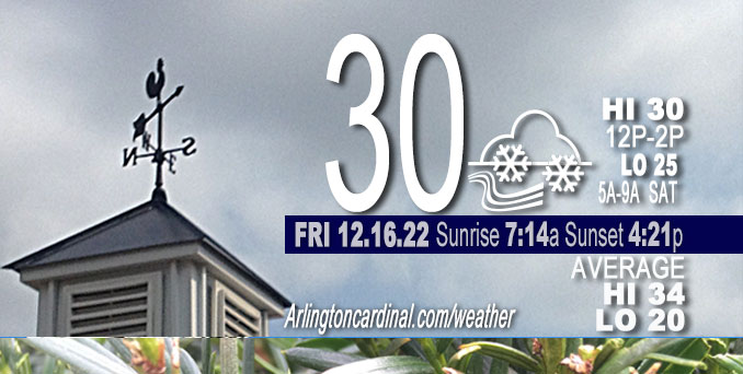
FRIDAY Hi 30, cloudy, light snow, winds SW, 17 to 16 MPH, G26 to 28 to 24 MPH
NWS CHGO | NWS HRLY | /NWSchicago | 🌡
ARLINGTON HEIGHTS WEATHER
▴ forecast7 (Arl. Hts.) | RADAR | WIDE RADAR
⏪ Hrly Data Table | Hrly Future Graph ⏩
IMPORTANT NOTE ON NWS DATA
⏪ Hrly Data Table | Hrly Future Graph ⏩
======================
Friday and Friday Night …
Weather Hazards expected…
Limited Snow Risk Friday and Saturday — Light snow, cold wind.
Limited Excessive Cold Risk Tuesday and Wednesday Dec. 20-21
Elevated Excessive Cold Risk Thursday Dec. 22
DISCUSSION…
Periods of snow showers will continue today, especially late morning through mid-afternoon. Some of these snow showers may produce high snowfall rates that, when combined with gusty winds, will result in sharp visibility reductions and a quick coating of snow. Chance for high snowfall rates ends after 3:00 p.m. Might get almost 0.5 inch of snow from noon to midnight Friday.
Hello mobile users! If you encounter a mobile “unfriendly” weather page, turn your phone sideways for a better view.
======================
O’HARE FORECAST …
Forecast Beginning Thursday, Dec. 15, 2022
Friday: Snow showers likely, mainly before 3pm. Cloudy, with a high near 31. Southwest wind around 15 mph, with gusts as high as 30 mph. Chance of precipitation is 60%. Total daytime snow accumulation of less than a half inch possible.
Friday Night: Scattered snow showers, mainly before midnight. Cloudy, with a low around 25. West southwest wind around 15 mph, with gusts as high as 25 mph. Chance of precipitation is 30%.
Saturday: Isolated snow showers. Cloudy, with a high near 29. West southwest wind around 15 mph, with gusts as high as 25 mph. Chance of precipitation is 20%.
Saturday Night: A chance of flurries before midnight. Mostly cloudy, with a low around 19. West wind 10 to 15 mph, with gusts as high as 25 mph.
Sunday: Mostly sunny, with a high near 27. West wind 10 to 15 mph, with gusts as high as 20 mph.
Sunday Night: Partly cloudy, with a low around 16.
Monday: Mostly cloudy, with a high near 30.
Monday Night: Mostly cloudy, with a low around 17.
Tuesday: Partly sunny, with a high near 26.
Tuesday Night: Mostly cloudy, with a low around 3.
Wednesday: A chance of snow. Mostly cloudy, with a high near 14.
Wednesday Night: Snow likely. Mostly cloudy, with a low around 6.
Thursday: A chance of snow. Mostly cloudy, with a high near 15.


CHICAGOWEATHERSTATION.COM

ChicagoWeatherStation.com I O’Hare Normal Temps/Precip I O’Hare Record Temps, Precip, Snow
LIVE RADAR | STORM TRACKS | UNISYS US IR SAT | UNISYS Midwest IR SAT | UNISYS More IR SAT
WunderMap® with Temperature/Wind Data || Google: Arlington Heights Area Temps | US TEMPS
Full Screen Motion Weather Radar (Wunderground.com)
Midwest Cloud Cover with Arlington Heights Weather Forecast
ChicagoWeatherStation.com I O’Hare Normal Temps/Precip I O’Hare Record Temps, Precip, Snow
SUNLIGHT DATA FOR SECURITY, TRAFFIC SAFETY, AND SPORTS
SunCalc.net data with solar azimuth and trajectory, times for dawn, sunrise, solar noon, sunset, dusk …
NIGHT SKY THIS MONTH …
Backyard stargazers get a monthly guide to the northern hemisphere’s skywatching events with “Tonight’s Sky.” Check the night sky objects for this month and past months in the playlist from the Space Telescope Science Institute YouTube channel (Musical track The Far River written by Jonn Serrie, from the album And the Stars Go With You courtesy of New World Music Ltd).
Get updates from The Cardinal ALL NEWS FEEDS on Facebook. Just ‘LIKE’ the ‘Arlington Cardinal Page (become a fan of our page). The updates cover all posts and sub-category posts from The Cardinal — Arlingtoncardinal.com. You can also limit feeds to specific categories. See all of The Cardinal Facebook fan pages at Arlingtoncardinal.com/about/facebook …
Help fund The Cardinal Arlingtoncardinal.com/sponsor
Area Forecast Discussion
National Weather Service Chicago/Romeoville, IL
1138 AM CST Fri Dec 16 2022
.SHORT TERM… Issued at 236 AM CST Fri Dec 16 2022
Through Saturday…
The area remains situated on the southeast side of an expansive stacked low centered over the MN/WI line early this morning. Several waves embedded in the deep cyclonic flow are evident in WV. The wave of primary focus for today is rotating into northern Iowa at this time. While this wave is a bit more sheared than Thursday afternoon`s wave, a more transverse orientation is expected to develop with eastward extent through the afternoon.
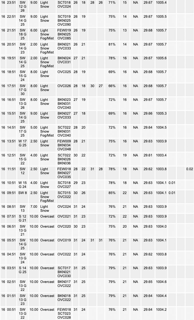
Forcing over the area through the day will be almost entirely confined to the approaching wave late this morning into the afternoon. Nearly unidirectional tropospheric-flow with increasing low-level diurnal instability aided by modest low-level CAA supports PBL horizontal-convective rolls as the primary precip mode today. Narrow SW-NE oriented filaments may become strong enough to produce locally moderate snow rates, especially around and southeast of I-55 where timing of the wave and peak diurnal heating align. While the overall forecast shows numerous snow shower coverage late morning through mid-afternoon with accumulations around one half inch, the narrow snow bands will likely result in amounts varying between a trace and up to 1″+ over short distances. Finally, while not anticipated, it is feasible that any longer-lived filaments begin to enhance low- level convergence akin to LES and produce local snow squall conditions with very low visibility and wind gusts to 30mph.
Forcing will greatly diminish behinds today`s wave, but with deep cyclonic flow persisting and saturated cloud depths still up to 3kft, isolated snow showers will remain in the forecast through Saturday. However, another wave will clip the northeast CWA toward daybreak Saturday through mid-morning, possibly enhancing snow shower coverage for a short window.
Kluber/NWS Chicago
