
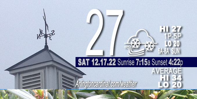
Saturday Hi 27, mostly cloudy, light snow, winds WSW to W, 17 to 15 MPH, G26 to 28 to 23 MPH
NWS CHGO | NWS HRLY | /NWSchicago | 🌡
ARLINGTON HEIGHTS WEATHER
▴ forecast7 (Arl. Hts.) | RADAR | WIDE RADAR
⏪ Hrly Data Table | Hrly Future Graph ⏩
IMPORTANT NOTE ON NWS DATA
⏪ Hrly Data Table | Hrly Future Graph ⏩
======================
Saturday and Saturday Night …
No Weather Hazards expected…
DISCUSSION…
An extended lull in precip is likely late Saturday morning into late afternoon assuming no additional small-scale embedded waves become evident over the next 12 hours. With deep cyclonic flow still in place during peak influence from the sun, intermittent flurries or light snow showers remain possible during this time. Some of the more optimistic guidance even tries to develop holes in the low- level stratus. Arlington Heights and nearby northwest suburbs could get another 0.3 inch of snow Saturday, especially after a light snowy period increases snowfall from 6:00 p.m. to 9:00 p.m. Think about 0.1 inch by 6:00 p.m. and then 0.2 inch from 6:00 p.m. to 10:00 p.m.
Hello mobile users! If you encounter a mobile “unfriendly” weather page, turn your phone sideways for a better view.
======================
O’HARE FORECAST …
Forecast Beginning Saturday, Dec. 17, 2022
Saturday: Isolated snow showers. Cloudy, with a high near 27. West wind around 15 mph, with gusts as high as 30 mph. Chance of precipitation is 20%.
Saturday Night: Scattered snow showers, mainly before 10pm. Cloudy, with a low around 20. West wind around 15 mph, with gusts as high as 25 mph. Chance of precipitation is 40%.
Sunday: Partly sunny, with a high near 26. West wind 10 to 15 mph, with gusts as high as 20 mph.
Sunday Night: Partly cloudy, with a low around 17. West wind 5 to 10 mph, with gusts as high as 15 mph.
Monday: A slight chance of flurries after 3pm. Mostly cloudy, with a high near 30. West wind around 5 mph becoming south southeast in the afternoon. Winds could gust as high as 10 mph.
Monday Night: A 20 percent chance of snow. Cloudy, with a low around 24.
Tuesday: Partly sunny, with a high near 30.
Tuesday Night: Mostly cloudy, with a low around 13.
Wednesday: A chance of snow after noon. Mostly cloudy, with a high near 25.
Wednesday Night: Snow likely. Cloudy, with a low around 15.
Thursday: Snow likely. Cloudy, with a high near 24.
Thursday Night: A chance of snow. Mostly cloudy, with a low around 6.
Friday: A chance of snow. Mostly cloudy, with a high near 15. Blustery.


CHICAGOWEATHERSTATION.COM

ChicagoWeatherStation.com I O’Hare Normal Temps/Precip I O’Hare Record Temps, Precip, Snow
LIVE RADAR | STORM TRACKS | UNISYS US IR SAT | UNISYS Midwest IR SAT | UNISYS More IR SAT
WunderMap® with Temperature/Wind Data || Google: Arlington Heights Area Temps | US TEMPS
Full Screen Motion Weather Radar (Wunderground.com)
Midwest Cloud Cover with Arlington Heights Weather Forecast
ChicagoWeatherStation.com I O’Hare Normal Temps/Precip I O’Hare Record Temps, Precip, Snow
SUNLIGHT DATA FOR SECURITY, TRAFFIC SAFETY, AND SPORTS
SunCalc.net data with solar azimuth and trajectory, times for dawn, sunrise, solar noon, sunset, dusk …
NIGHT SKY THIS MONTH …
Backyard stargazers get a monthly guide to the northern hemisphere’s skywatching events with “Tonight’s Sky.” Check the night sky objects for this month and past months in the playlist from the Space Telescope Science Institute YouTube channel (Musical track The Far River written by Jonn Serrie, from the album And the Stars Go With You courtesy of New World Music Ltd).
Get updates from The Cardinal ALL NEWS FEEDS on Facebook. Just ‘LIKE’ the ‘Arlington Cardinal Page (become a fan of our page). The updates cover all posts and sub-category posts from The Cardinal — Arlingtoncardinal.com. You can also limit feeds to specific categories. See all of The Cardinal Facebook fan pages at Arlingtoncardinal.com/about/facebook …
Help fund The Cardinal Arlingtoncardinal.com/sponsor
Area Forecast Discussion
National Weather Service Chicago/Romeoville, IL
521 AM CST Sat Dec 17 2022
.SHORT TERM… Issued at 238 AM CST Sat Dec 17 2022
Through Sunday…
The massive upper-level low that has brought unsettled weather to the area for the past few days has drifted only a couple hundred miles eastward to northeast Wisconsin over the past 24 hours. Several embedded vort lobes of different scales continue to rotate around the southwest flank of the low, which has resulted in periods of snow across the forecast area since Thursday afternoon. More of the same is expected today, with three (currently evident) waves likely to affect northern Illinois and northwest Indiana through this evening.
Wave 1 is currently shifting across northeast Illinois into eastern Wisconsin, bringing a locally enhanced band of snow into the Chicago metro. A brief couple tenths of an inch of snow are possible through 3-4am with this band.
Wave 2 is defined by some mid-level cloud enhancement across central Iowa and is expected to drift across far northern Illinois from the pre-dawn hours into mid-morning. With inversion heights lowering and the overall saturated depth decreasing and warming outside the DGZ, snow quality will be poor and snow intensity should be subdued. Nonetheless, an enhanced area of snow is likely north of I-80 during this time with a tenth or two of an inch of snow.
An extended lull in precip is likely late morning into late afternoon assuming no additional small-scale embedded waves become evident over the next 12 hours. With deep cyclonic flow still in place during peak influence from the sun, intermittent flurries or light snow showers remain possible during this time. Some of the more optimistic guidance even tries to develop holes in the low- level stratus. This would not be entirely surprising given upstream trends since last evening and increasingly shallow cloud depths, so some peaks of the sun for the first time in many days is a distinct possibility.
Wave 3 is noted as a more potent vort max along the Red River of the North early this morning and is progged to sweep across the CWA early to mid-evening. Precip coverage and intensity will depend on how cloud cover evolves today, but at least scattered snow showers to perhaps an area of steady snow is expected. Additional minor accumulations under a half inch are possible.
The main forecast challenge overnight through Sunday will be the timing of clearing from the southwest. Expansive stratus wrapping back into Manitoba does not bode well for any substantial clearing overnight. But with the upper-low finally departing to the east on Sunday and the noted shallow cloud depths, even subtle low- level drying should erode the existing cloud cover from southwest to northeast through the day Sunday.
Kluber/NWS Chicago
