
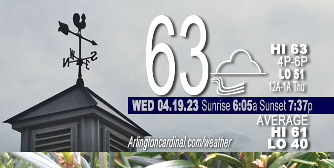
Wednesday Hi 63, mostly cloudy, chance thunderstorm, winds E to NE to E to N to NE, 6 to 13 to 5 MPH, G17 to 21 to 18 MPH
NWS CHGO | NWS HRLY | /NWSchicago | 🌡
ARLINGTON HEIGHTS WEATHER
▴ forecast7 (Arl. Hts.) | RADAR | WIDE RADAR
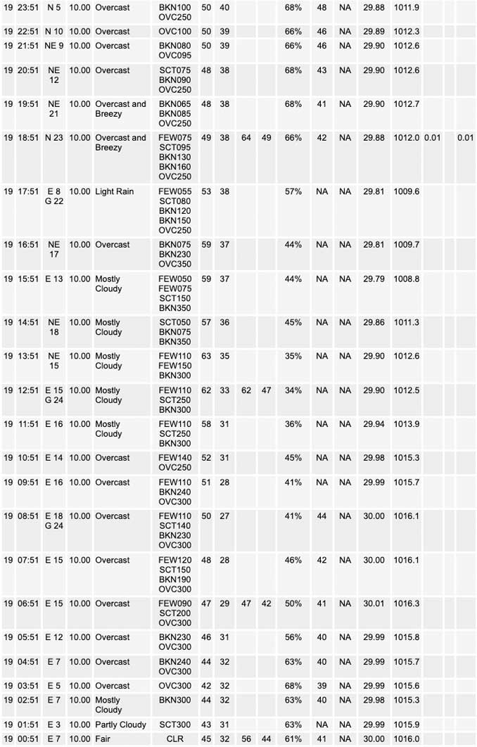
⏪ Hrly Data Table | Hrly Future Graph ⏩
IMPORTANT NOTE ON NWS DATA
⏪ Hrly Data Table | Hrly Future Graph ⏩
Hello mobile users! If you encounter a mobile “unfriendly” weather page, turn your phone sideways for a better view.
======================
Wednesday and Wednesday Evening …
Weather Hazards expected …
Limited Thunderstorm Risk…with an associated:
Limited Hail Risk…up to ping pong ball size, or 1.5 inches diameter.
DISCUSSION…
An isolated thunderstorm or two may develop this afternoon in northern Illinois. If a thunderstorm develops, it may produce damaging hail as large as ping pong balls. Most areas will stay dry.
Additional thunderstorms may approach Interstate 39 after midnight tonight with a threat for gusty winds. Severe weather is not expected overnight.
UPDATE: Storms barely made it all the way to the northwest suburbs with a little rain and a little thunder and lightning, surpassing the forecast location of Interstate 39 for this pre-dawn thunderstorm system. Storms Wednesday afternoon dissipated before reaching the northwest suburbs.
======================
O’HARE FORECAST …
Forecast Beginning Wednesday, Apr. 19, 2023
Wednesday: A 10 percent chance of showers and thunderstorms after 5pm. Partly sunny, with a high near 67. Southeast wind around 15 mph, with gusts as high as 20 mph.
Wednesday Night: A slight chance of showers and thunderstorms before 7pm, then a slight chance of showers and thunderstorms after 3am. Mostly cloudy, with a low around 53. East southeast wind around 10 mph becoming south in the evening. Winds could gust as high as 15 mph. Chance of precipitation is 20%.
Thursday: Showers and thunderstorms likely, mainly after 4pm. Mostly cloudy, with a high near 74. Breezy, with a south southwest wind 10 to 20 mph, with gusts as high as 30 mph. Chance of precipitation is 60%. New rainfall amounts between a quarter and half of an inch possible.
Thursday Night: Showers and thunderstorms likely, mainly before 10pm. Mostly cloudy, with a low around 47. Breezy, with a south southwest wind 15 to 20 mph becoming west 5 to 10 mph after midnight. Winds could gust as high as 30 mph. Chance of precipitation is 60%.
Friday: A 20 percent chance of showers after 1pm. Partly sunny, with a high near 64. South southwest wind 5 to 15 mph, with gusts as high as 20 mph.
Friday Night: A 30 percent chance of showers, mainly before 1am. Mostly cloudy, with a low around 40.
Saturday: A 30 percent chance of showers, mainly after 1pm. Partly sunny, with a high near 49. Breezy.
Saturday Night: Mostly cloudy, with a low around 35.
Sunday: Partly sunny, with a high near 47.
Sunday Night: Partly cloudy, with a low around 34.
Monday: Mostly sunny, with a high near 56.
Monday Night: Partly cloudy, with a low around 40.
Tuesday: Partly sunny, with a high near 59.


CHICAGOWEATHERSTATION.COM

ChicagoWeatherStation.com I O’Hare Normal Temps/Precip I O’Hare Record Temps, Precip, Snow
WunderMap® with Temperature/Wind Data || Google: Arlington Heights Area Temps | US TEMPS
Midwest Cloud Cover with Arlington Heights Weather Forecast
ChicagoWeatherStation.com I O’Hare Normal Temps/Precip I O’Hare Record Temps, Precip, Snow
SUNLIGHT DATA FOR SECURITY, TRAFFIC SAFETY, AND SPORTS
SunCalc.net data with solar azimuth and trajectory, times for dawn, sunrise, solar noon, sunset, dusk …
NIGHT SKY THIS MONTH …
Backyard stargazers get a monthly guide to the northern hemisphere’s skywatching events with “Tonight’s Sky.” Check the night sky objects for this month and past months in the playlist from the Space Telescope Science Institute YouTube channel (Musical track The Far River written by Jonn Serrie, from the album And the Stars Go With You courtesy of New World Music Ltd).
Get updates from The Cardinal ALL NEWS FEEDS on Facebook. Just ‘LIKE’ the ‘Arlington Cardinal Page (become a fan of our page). The updates cover all posts and sub-category posts from The Cardinal — Arlingtoncardinal.com. You can also limit feeds to specific categories. See all of The Cardinal Facebook fan pages at Arlingtoncardinal.com/about/facebook …
Help fund The Cardinal Arlingtoncardinal.com/sponsor
/////////////>
Area Forecast Discussion
National Weather Service Chicago/Romeoville, IL
643 AM CDT Wed Apr 19 2023
.SHORT TERM… Issued at 333 AM CDT Wed Apr 19 2023
Through Thursday Evening…
Large mid-upper level trough over the western U.S. is slowing translating eastward and will be the dominant weather maker through Thursday. Strengthening warm front downstate extends west to organizing low pressure system over the central Plains. Well defined lead shortwave trough was responsible for the blow up of convection of Nebraska into Iowa last evening into the overnight hours. Forecast highlights for the short term include…
* Large temp gradient likely this afternoon into tonight on either side of the slowly northward advancing strong warm front. * Small chance of showers/t-storms through this evening, then slowly increasing chances late tonight and Thursday. * Low end/marginal (level 1 of 5) risk of severe weather late tonight and again Thursday.
Brunt of the forcing with aforementioned lead shortwave trough looks likely to pass north of our CWA. Combination of weaker large scale ascent/forcing and progressively more stable/dry air with eastward extent suggests that there will just be some isolated showers and perhaps a t-storm this morning over mainly northwest portion of the CWA.
Warm front is forecast to lift north to the vicinity of the I-88/I-290 corridor by this afternoon. On the warm side of this boundary, temperatures will likely climb into the lower 80s. To the north of the boundary, temperatures will likely hold in the 50s, perhaps struggling to even reach 50F along the IL north shore. Guidance varies with how far north the front gets, so hard to say who gets into the warm sector and who stays chilly today, but seems likely it will bisect the Chicago metro area and northern IL.
Guidance isn`t showing any meaningful shortwave and not seeing anything on water vapor imagery, which suggests the potential for convection along the warm front this afternoon is on the lower end of the spectrum. Still have some guidance showing convection initiation near/just north of the front, but given expected capping and lack of deep moisture near the warm front would suggest the better chances of shower and thunderstorms would be far north and into WI where isentropic ascent may be able to lift parcels to their LFC.
Strong/severe t-storms are expected to develop near upstream triple point across the western Corn Belt later this afternoon. This activity could develop a cold pool and forward propagate eastward tonight to the MS River and eventually our western CWA late tonight. Generally anticipate a weakening trend in this convection as it approaches our CWA late tonight as it propagates into decreasing instability. If this activity were to develo Pinto into well organized MCS, effective shear would support it maintaining at least some marginal damaging wind threat potentially this far east despite weakening instability. Overall, this threat appears low, in line with SPC`s marginal risk.
The weakening MCS will pose a threat of showers and perhaps some thunder across our CWA Thursday morning, especially west. While robust cold front will sweep across the CWA Thursday afternoon into the early evening with strong shear profiles, there are big question marks with regard to instability. Morning convection could disrupt destabilization Thursday ahead of the cold front, which even if it isn`t disrupted, looks to be pretty limited and largely confined to a narrow ribbon of moisture ahead of the front. Severe potential Thursday will hinge heavily on how unstable atmosphere will become, which is hard to predict at this distance. Given the expected seasonably strong shear profiles, Thursday afternoon and evening bears watching for a severe potential.
– Izzi/NWS Chicago
