
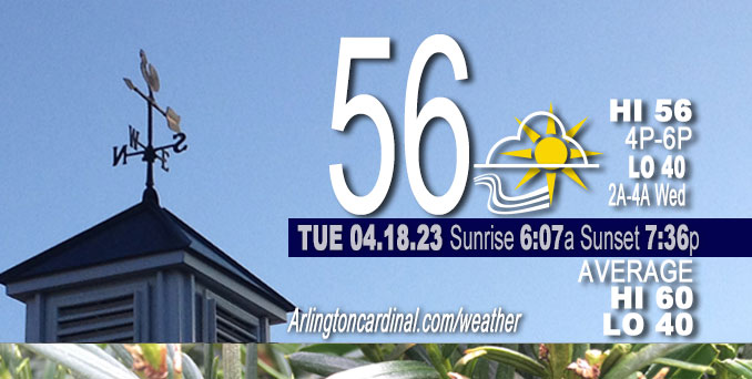
Tuesday Hi 56, mostly sunny, winds W to NW, 6 to 13 to 5 MPH, G17 to 21 to 18 MPH
NWS CHGO | NWS HRLY | /NWSchicago | 🌡
ARLINGTON HEIGHTS WEATHER
▴ forecast7 (Arl. Hts.) | RADAR | WIDE RADAR
⏪ Hrly Data Table | Hrly Future Graph ⏩
IMPORTANT NOTE ON NWS DATA
⏪ Hrly Data Table | Hrly Future Graph ⏩
Hello mobile users! If you encounter a mobile “unfriendly” weather page, turn your phone sideways for a better view.
======================
Tuesday and Tuesday Evening …
Weather Hazards expected …
Elevated Non Thunderstorm Wind Risk.
Significant Freeze Risk Tonight.
DISCUSSION…
A couple non-severe thunderstorms are possible prior to daybreak Wednesday in far northern Illinois.
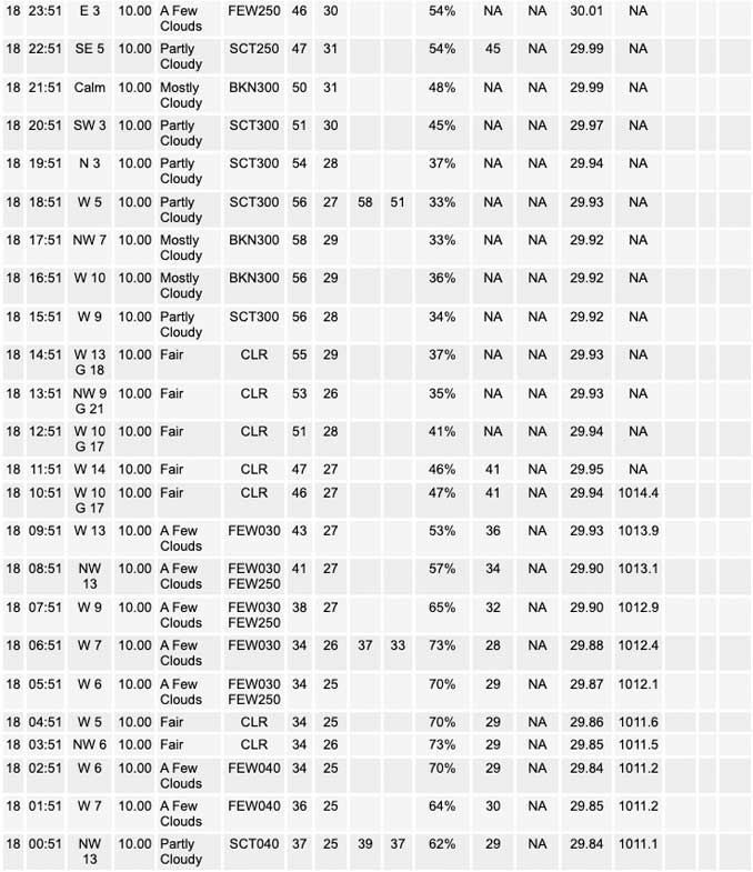
Low 40°F and very light east winds, clouds increase after 1:00 a.m. so we’ll see if low temperature is above 40°F.
UPDATE: Low was 42°F
======================
O’HARE FORECAST …
Forecast Beginning Tuesday, Apr. 18, 2023
Tuesday: Sunny, with a high near 56. Northwest wind around 10 mph.
Tuesday Night: A 10 percent chance of showers and thunderstorms after 5am. Increasing clouds, with a low around 40. Northwest wind around 5 mph becoming east after midnight. Winds could gust as high as 15 mph.
Wednesday: A slight chance of showers and thunderstorms before 7am, then a chance of showers and thunderstorms after 10am. Mostly cloudy, with a high near 66. East southeast wind 10 to 15 mph, with gusts as high as 25 mph. Chance of precipitation is 30%.
Wednesday Night: A 40 percent chance of showers and thunderstorms, mainly after 1am. Mostly cloudy, with a low around 55. East southeast wind 10 to 15 mph becoming south after midnight. Winds could gust as high as 30 mph.
Thursday: Showers and possibly a thunderstorm. High near 71. Breezy, with a south wind 15 to 25 mph, with gusts as high as 40 mph. Chance of precipitation is 80%.
Thursday Night: A chance of showers and thunderstorms before 4am, then a slight chance of showers. Mostly cloudy, with a low around 45. Breezy. Chance of precipitation is 40%.
Friday: Mostly sunny, with a high near 62.
Friday Night: A chance of showers. Mostly cloudy, with a low around 40.
Saturday: A chance of showers. Mostly cloudy, with a high near 44.
Saturday Night: Mostly cloudy, with a low around 34.
Sunday: Partly sunny, with a high near 48.
Sunday Night: Partly cloudy, with a low around 35.
Monday: Mostly sunny, with a high near 55.


CHICAGOWEATHERSTATION.COM

ChicagoWeatherStation.com I O’Hare Normal Temps/Precip I O’Hare Record Temps, Precip, Snow
WunderMap® with Temperature/Wind Data || Google: Arlington Heights Area Temps | US TEMPS
Midwest Cloud Cover with Arlington Heights Weather Forecast
ChicagoWeatherStation.com I O’Hare Normal Temps/Precip I O’Hare Record Temps, Precip, Snow
SUNLIGHT DATA FOR SECURITY, TRAFFIC SAFETY, AND SPORTS
SunCalc.net data with solar azimuth and trajectory, times for dawn, sunrise, solar noon, sunset, dusk …
NIGHT SKY THIS MONTH …
Backyard stargazers get a monthly guide to the northern hemisphere’s skywatching events with “Tonight’s Sky.” Check the night sky objects for this month and past months in the playlist from the Space Telescope Science Institute YouTube channel (Musical track The Far River written by Jonn Serrie, from the album And the Stars Go With You courtesy of New World Music Ltd).
Get updates from The Cardinal ALL NEWS FEEDS on Facebook. Just ‘LIKE’ the ‘Arlington Cardinal Page (become a fan of our page). The updates cover all posts and sub-category posts from The Cardinal — Arlingtoncardinal.com. You can also limit feeds to specific categories. See all of The Cardinal Facebook fan pages at Arlingtoncardinal.com/about/facebook …
Help fund The Cardinal Arlingtoncardinal.com/sponsor
/////////////>
Area Forecast Discussion
National Weather Service Chicago/Romeoville, IL
614 AM CDT Tue Apr 18 2023
.SHORT TERM… Issued at 240 AM CDT Tue Apr 18 2023
Through Wednesday…
Key Messages:
* Chance for semi-organized showers and storms in northern Illinois on Wednesday, with marginally severe storms possible mainly north of I-80
* Challenging temperature forecast for Wednesday afternoon with a plausible large gradient near/north of I-80 (mid 50s to mid- upper 70s) aided by gusty winds in opposing directions
The deep, closed upper low responsible for the 80s to 30s temperature swing in recent days is in the eastern Great Lakes and departing, being replaced by upper level ridging. Surface high pressure will accompany this and move over the CWA during mid- late afternoon, resulting in the development of a lake breeze. All in all, highs will add 10 to 15 degrees from yesterday and peak in the 50s under full sunshine.
A developing upper trough across the northwestern quarter of the country is forecast to spread upper diffluence across the Midwest late tonight into Wednesday, with cyclogenesis ensuing in the Central Plains. Broad warm air advection (WAA) will shift steeper lapse rates aloft into the Mississippi River Valley region overnight. Guidance is in sound agreement for there also to be a low amplitude but pronounced upper level short wave to move across Iowa overnight and into Wisconsin Wednesday morning/early afternoon. Forecast 500-700 mb flow is 50 kt with this, and this provides a source of lift that may compensate for otherwise limited deep layer moisture. A majority of model guidance say that it will, with a QPF focus centered northwest to north of the area where the strongest potential vorticity advection from the wave is focused. However, the elevated instability gradient is shar Pand slopes southeast into the CWA, especially Wednesday morning, and isentropic ascent crossing this may result in scattered shower or storm development. A couple solutions from 00Z convection- allowing models (CAMs) indicate some semi-organized clustered convection near the Wisconsin/Illinois border Wednesday morning, even resulting in progressive outflows and 40+ mph gusts. With deep player shear forecast at 50 kt and MUCAPE of 500-1,000 J/kg, there is isolated severe hail and wind potential with this setup.
Any outflows from convection the first half of the day will enhance a developing warm front extending east from the aforementioned Central Plains low. This boundary looks to be over the forecast area throughout the afternoon. Because of continued limited deep layer moisture and increasing temperatures aloft, capping looks as if it should keep the front dormant Wednesday mid-late afternoon, but always something to re-analyze this time of year. The front will, however, introduce the chance for a large temperature forecast bust. Winds off the lake north of the boundary, possibly enhanced by outflows, could easily keep highs in the 50s (even some upper 40s lakeside). At the same time, south of the front will be within an increasing zone of pressure falls and deeper mixing, supporting gusts over 30 mph and warming into and possibly well into the 70s. The gradient in temperatures could be markedly sharp including in the Chicago metro. As simply an example of this, the 00Z HRRR depicted Wednesday highs of 48 in Waukegan and 78 at Midway Airport. Needless to say, we do not have that tight of a temperature gradient forecast, but did cool things lake side and near the Wisconsin border some, while increased the forecast warmth south of I-80. For more after this point, please see the Long Range Discussion.
The last couple days and those upcoming showcase true Midwestern spring. Such atmospheric swings keep us meteorologists humble and make us value forecast analysis and interpreting this during our shifts, and this happens to be the last shift for myself with the NWS Chicago team (and what a super team they are!). A thank you to the north central and northeast Illinois and northwest Indiana core partners, trained storm spotters, decision-makers, and weather aficionados who use and relay forecasts and warnings. Stay weather-ready and enjoy this highly variable spring weather!
MTF/NWS Chicago
