
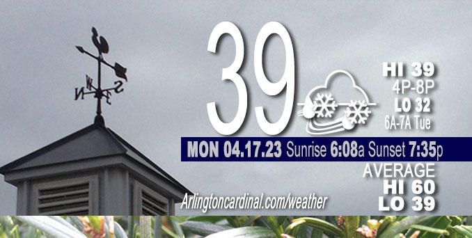
Monday Hi 39, mostly cloudy, snow and rain, winds NW, 21 to 26 to 18 MPH, G33 to 41 to 29 MPH, continuing Tuesday
NWS CHGO | NWS HRLY | /NWSchicago | 🌡
ARLINGTON HEIGHTS WEATHER
▴ forecast7 (Arl. Hts.) | RADAR | WIDE RADAR
⏪ Hrly Data Table | Hrly Future Graph ⏩
IMPORTANT NOTE ON NWS DATA
⏪ Hrly Data Table | Hrly Future Graph ⏩
Hello mobile users! If you encounter a mobile “unfriendly” weather page, turn your phone sideways for a better view.
======================
Monday and Monday Evening …
Weather Hazards expected …
Elevated Non Thunderstorm Wind Risk.
Significant Freeze Risk Tonight.
DISCUSSION…
Northwest winds will gust to 40 to 45 mph today, blowing unsecured objects and making travel difficult for high profile vehicles.
Low temperatures tonight will drop to or below freezing, especially for outlying areas of northern Illinois.
======================
O’HARE FORECAST …
Forecast Beginning Monday, Apr. 17, 2023
Monday: Periods of snow showers before 2pm, then scattered rain and snow showers. High near 39. Breezy, with a west northwest wind 20 to 25 mph, with gusts as high as 40 mph. Chance of precipitation is 80%. Total daytime snow accumulation of less than a half inch possible.
Monday Night: Isolated snow showers before 7pm. Cloudy during the early evening, then gradual clearing, with a low around 32. Breezy, with a west northwest wind 15 to 25 mph, with gusts as high as 40 mph. Chance of precipitation is 10%.
Tuesday: Sunny, with a high near 55. Northwest wind 10 to 15 mph, with gusts as high as 20 mph.
Tuesday Night: A 20 percent chance of showers and thunderstorms after 1am. Mostly clear, with a low around 40. East wind 5 to 10 mph.
Wednesday: A 30 percent chance of showers and thunderstorms, mainly after 1pm. Partly sunny, with a high near 67. East southeast wind 10 to 15 mph, with gusts as high as 25 mph.
Wednesday Night: A 50 percent chance of showers and thunderstorms. Mostly cloudy, with a low around 56.
Thursday: Showers and possibly a thunderstorm. High near 73. Breezy. Chance of precipitation is 80%.
Thursday Night: A chance of showers. Partly cloudy, with a low around 44. Breezy.
Friday: A chance of showers after 1pm. Partly sunny, with a high near 60.
Friday Night: A chance of showers. Mostly cloudy, with a low around 39.
Saturday: A chance of showers. Mostly cloudy, with a high near 48.
Saturday Night: Mostly cloudy, with a low around 35.
Sunday: Partly sunny, with a high near 50.


CHICAGOWEATHERSTATION.COM

ChicagoWeatherStation.com I O’Hare Normal Temps/Precip I O’Hare Record Temps, Precip, Snow
WunderMap® with Temperature/Wind Data || Google: Arlington Heights Area Temps | US TEMPS
Midwest Cloud Cover with Arlington Heights Weather Forecast
ChicagoWeatherStation.com I O’Hare Normal Temps/Precip I O’Hare Record Temps, Precip, Snow
SUNLIGHT DATA FOR SECURITY, TRAFFIC SAFETY, AND SPORTS
SunCalc.net data with solar azimuth and trajectory, times for dawn, sunrise, solar noon, sunset, dusk …
NIGHT SKY THIS MONTH …
Backyard stargazers get a monthly guide to the northern hemisphere’s skywatching events with “Tonight’s Sky.” Check the night sky objects for this month and past months in the playlist from the Space Telescope Science Institute YouTube channel (Musical track The Far River written by Jonn Serrie, from the album And the Stars Go With You courtesy of New World Music Ltd).
Get updates from The Cardinal ALL NEWS FEEDS on Facebook. Just ‘LIKE’ the ‘Arlington Cardinal Page (become a fan of our page). The updates cover all posts and sub-category posts from The Cardinal — Arlingtoncardinal.com. You can also limit feeds to specific categories. See all of The Cardinal Facebook fan pages at Arlingtoncardinal.com/about/facebook …
Help fund The Cardinal Arlingtoncardinal.com/sponsor
/////////////>
Area Forecast Discussion
National Weather Service Chicago/Romeoville, IL
649 AM CDT Mon Apr 17 2023
.SHORT TERM… Issued at 258 AM CDT Mon Apr 17 2023
Through Tuesday…
Key Messages:
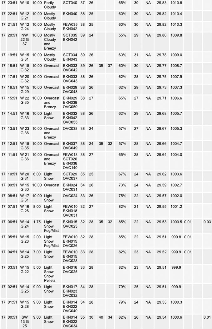
* Periods of snow showers today, with the most persistent being in northeast Illinois and far northwest Indiana; potential for brief sharply reduced visibility and a light coating on grass
* Blustery and seasonably cold, with northwest winds sporadically gusting over 40 mph at times, and morning wind chills of 15 to 25F (60F colder than air temperatures just 36 hours ago)
* Sub-freezing low temperatures tonight across much of northern Illinois and possible in northwest Indiana
Early morning satellite imagery captures the closed low centered over eastern Wisconsin/Lake Michigan, with a “cinnamon bun” look to it from the dry conveyor belt wrapping around the center and surrounded by the higher moisture areas. This indicates the low is entering occlusion, and indeed the radar presentation has shown more corridors of snow showers vs. a large snow shield. Embedded vorticity maximums near the center of upper level circulation have seem correlated with enhanced snow shower coverage on their leading edges. A couple of these are forecast to move across northeast Illinois and far northwest Indiana through early afternoon, and may focus some snow showers capable of reducing visibility down to near or just under a mile temporarily. Thus far in the CWA, observations have indicated such low visibilities are both short lasting and low in coverage.
Accumulations have been seen on grass toward the Wisconsin state line per webcam imagery, including the grass being covered in several spots of Winnebago and Boone Counties as of 230 AM. Still no signs of road accumulation, and given pavement temperatures into the upper 30s or lower 40s that continues to look unlikely today. Scattered but short-lasting sharply reduced visibilities due to the snow shower nature, along with gusty winds, is the main snow item to note. That includes the possibility during the afternoon in northeast Illinois and far northwest Indiana, when more convective-like snow showers might develop based on forecast soundings showing 0-2 km CAPE of up to 20-40 J/kg.
Regarding the winds, these have been under-performing early this morning, and this probably is due to limited pressure rises because of the stagnant surface low center over far northern Lake Michigan. During the daytime hours, the pressure rises start to increase in tandem with the higher April sun angle, and would think gusts to 35-40 mph will become common with sporadic gusts higher than that. The current Wind Advisory area captures the locations where the stratocumulus should be at its thinnest later today and mixing depths are accordingly higher. To the east of that, there is potential for a few Advisory gusts, including if more convective-like snow showers develop this afternoon.
Temperatures will struggle to warm much today, and this same setu Ptwo months ago would likely result in literally no warming. Expecting upper 30s to lower 40s for most locales. With the cool starting point, temperatures will not be that far from freezing heading into tonight. As the upper low pulls away from the area with greater haste tonight and height rises build into the region, clearing will work its way from west to east this evening. This may take its time in far northeast Illinois and northwest Indiana though, not arriving toward or even a little after midnight. This may keep some areas from dropping below freezing tonight. Outlying locations in Illinois are most likely to go below freezing for numerous hours, including upper 20s. Winds will still be gusty this evening and then gradually slacken overnight but still around 10 mph at the coldest time of day. So this is not matching the “classic” freeze situation, but just due to the cold regime, sub-freezing temperatures will occur. If trends continue, the day shift will likely need to issue a Freeze Warning for a good portion of outlying Illinois locations.
Northwest winds gradually ease through the day Tuesday under full sun. Temperatures will be around 15 degrees warmer than today. A lake breeze is likely late afternoon for near-lakeside locations.
MTF/NWS Chicago
