
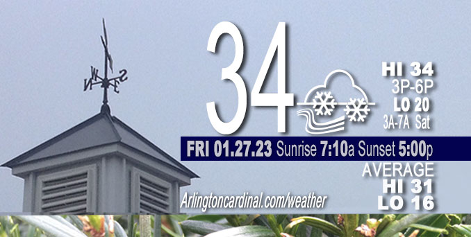
Friday Hi 34, light snow ends 3p, cloudy with some clearing after 5p, winds S to SW to W, 21 to 22 to 16 MPH, G36 to 37 to 24 MPH
NWS CHGO | NWS HRLY | /NWSchicago | 🌡
ARLINGTON HEIGHTS WEATHER
▴ forecast7 (Arl. Hts.) | RADAR | WIDE RADAR
⏪ Hrly Data Table | Hrly Future Graph ⏩
IMPORTANT NOTE ON NWS DATA
⏪ Hrly Data Table | Hrly Future Graph ⏩
======================
Friday and Friday Night …
Weather Hazards expected …
Limited Excessive Cold Risk in the morning.
Limited Non Thunderstorm Wind Risk.
Limited Snow and Blowing Snow Risk.
DISCUSSION…
Snow amounting to less than one-half inch is forecast during the daylight hours of 9:00 a.m. to 4:00 p.m. Friday. Then tomorrow, accumulating snow is likely Saturday into Saturday night, primarily near and north of I-80. Several inches of accumulation are forecast Saturday (3.8 inches for Arlington Heights), with the highest amounts favored north of I-88. In addition, the potential exists for freezing rain and some ice accumulation south of I-80 Saturday evening into the overnight period.
One more day left of the normal daily low temperature bottomed out at 16°F. Normal daily high increases from 31°F to 32°F in four days. We’re gaining about 2 minutes of daylight every day in the progression toward vernal equinox, March 20, 2023. Sunset reaches the milestone of 5:00 p.m. today.
======================
O’HARE FORECAST …
Forecast Beginning Friday, Jan. 27, 2023
Thursday: Snow before 1pm, then snow showers likely, mainly after 4pm. High near 30. West wind 5 to 10 mph, with gusts as high as 20 mph. Chance of precipitation is 80%. Total daytime snow accumulation of less than one inch possible.
Thursday Night: Snow showers likely, mainly before 7pm. Cloudy, then gradually becoming partly cloudy, with a low around 18. West wind around 10 mph becoming south southwest after midnight. Winds could gust as high as 20 mph. Chance of precipitation is 60%. New snow accumulation of less than a half inch possible.
Friday: Snow showers likely, mainly between 7am and 1pm. Cloudy, with a high near 34. South wind around 15 mph, with gusts as high as 35 mph. Chance of precipitation is 70%. New snow accumulation of less than a half inch possible.
Friday Night: A chance of snow showers before 7pm, then a chance of sprinkles and flurries between 7pm and 1am. Mostly cloudy, with a low around 21. Breezy, with a west southwest wind 15 to 20 mph decreasing to 5 to 10 mph after midnight. Winds could gust as high as 30 mph. Chance of precipitation is 30%.
Saturday: Snow likely, mainly after 1pm. Cloudy, with a high near 30. West wind 5 to 10 mph becoming east northeast in the afternoon. Chance of precipitation is 70%.
Saturday Night: Snow likely, mainly before 1am. Cloudy, with a low around 22. Chance of precipitation is 70%.
Sunday: A 20 percent chance of snow before 7am. Mostly cloudy, with a high near 27.
Sunday Night: Mostly cloudy, with a low around 15.
Monday: Mostly cloudy, with a high near 21.
Monday Night: Mostly cloudy, with a low around 5.
Tuesday: Mostly sunny, with a high near 18.
Tuesday Night: A chance of snow. Mostly cloudy, with a low around 9.
Wednesday: A chance of snow. Mostly cloudy, with a high near 19.


CHICAGOWEATHERSTATION.COM

ChicagoWeatherStation.com I O’Hare Normal Temps/Precip I O’Hare Record Temps, Precip, Snow
LIVE RADAR | STORM TRACKS | UNISYS US IR SAT | UNISYS Midwest IR SAT | UNISYS More IR SAT
WunderMap® with Temperature/Wind Data || Google: Arlington Heights Area Temps | US TEMPS
Full Screen Motion Weather Radar (Wunderground.com)
Midwest Cloud Cover with Arlington Heights Weather Forecast
ChicagoWeatherStation.com I O’Hare Normal Temps/Precip I O’Hare Record Temps, Precip, Snow
SUNLIGHT DATA FOR SECURITY, TRAFFIC SAFETY, AND SPORTS
SunCalc.net data with solar azimuth and trajectory, times for dawn, sunrise, solar noon, sunset, dusk …
NIGHT SKY THIS MONTH …
Backyard stargazers get a monthly guide to the northern hemisphere’s skywatching events with “Tonight’s Sky.” Check the night sky objects for this month and past months in the playlist from the Space Telescope Science Institute YouTube channel (Musical track The Far River written by Jonn Serrie, from the album And the Stars Go With You courtesy of New World Music Ltd).
Get updates from The Cardinal ALL NEWS FEEDS on Facebook. Just ‘LIKE’ the ‘Arlington Cardinal Page (become a fan of our page). The updates cover all posts and sub-category posts from The Cardinal — Arlingtoncardinal.com. You can also limit feeds to specific categories. See all of The Cardinal Facebook fan pages at Arlingtoncardinal.com/about/facebook …
Help fund The Cardinal Arlingtoncardinal.com/sponsor
Area Forecast Discussion
National Weather Service Chicago/Romeoville, IL
543 AM CST Fri Jan 27 2023
.SHORT TERM… Issued at 304 AM CST Fri Jan 27 2023
Through tonight…
Water vapor imagery early this morning shows mid-upper level trough digging into the northern and central Plains and heading for the mid-upper Mississippi Valley. A couple well defined, potent looking vorts are embedded within the broader trough, the southern most one over eastern South Dakota will be our problem maker today. Thursday evening RAOBS and SPC mesoanalysis both show a large area of steep mid-upper level lapse rates associated with this trough, and its these lapse rates that are supporting the convective looking precip across MN and IA early this morning.
The forcing associated with the trough and in particular the strong vort over eastern SD will quickly overspread northern IL later this morning. While time/height cross sections suggest the strongest ascent will be above the dendritic growth zone (DGZ), the steep lapse suggest some convective enhancement is pretty likely and could result in more impressive ascent, including through the DGZ. With temps initially solidly below freezing, there should be a band of wind driven accumulating snow moving across the area later this morning into the afternoon.
Initially low level dry air will need to be overcome; the stronger forcing is progged to be over our northern CWA where we`ve continued with categorical pops. Over southern CWA, forcing isn`t progged to be quite as strong and it is more questionable if the dry low level air will be overcome, so maintained high end chance pops there. Looking upstream, similar scenario is playing out over southern IA with CIGS remaining high and fewer reports of precip.
While snow could fall rather heavily for a time with this initial band, the duration looks to be fairly short, likely limiting accumulations to less than in inch. Strong winds will accompany this band of snow with gusts of 30 to 40 mph appearing fairly likely. The strong winds will result in blowing snow and further lowering visibility during the snow. Plan to freshen up and reissue the SPS for this snow/wind.
More showery precipitation is expected to continue in the wake of the initial band behind the north-south oriented warm front and ahead of the cold front that will be fast on the heels of the warm front. Maintained mostly snow showers in the forecast for this afternoon, but it is possible that there could be some rain showers or ice pellets with the early afternoon shower activity as far north perhaps the I-88/I-290 corridors. Day shift will need to monitor trends and may need to make adjustments accordingly.
Mid-upper levels quickly dry out in the wake of this trough passage later this afternoon resulting in an end to the precipitation. Could briefly see some breaks in the clouds tonight before mid-high cloudiness ahead of the next wave move in. Winds will quickly diminish tonight, but cloud cover should keep temps more in check tonight vs what we`re seeing early this morning with clear skies.
– Izzi/NWS Chicago
