
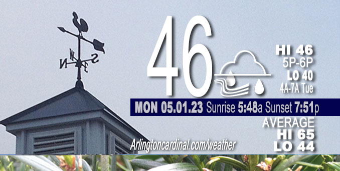
Monday Hi 46, mostly cloudy, winds NW, 21 to 22 to 17 MPH, G25 to 34 to 29 MPH, 3a Monday into Tuesday
NWS CHGO | NWS HRLY | /NWSchicago | 🌡
ARLINGTON HEIGHTS WEATHER
▴ forecast7 (Arl. Hts.) | RADAR | WIDE RADAR
⏪ Hrly Data Table | Hrly Future Graph ⏩
IMPORTANT NOTE ON NWS DATA
⏪ Hrly Data Table | Hrly Future Graph ⏩
Hello mobile users! If you encounter a mobile “unfriendly” weather page, turn your phone sideways for a better view.
======================
Monday and Monday Evening …
Weather Hazards expected …
Limited Non Thunderstorm Wind Risk.
DISCUSSION…
Northwesterly winds will gust up to 45 mph today, especially near and west of I-39.
======================
O’HARE FORECAST …
Forecast Beginning Monday, May 01, 2023
Monday: Showers. High near 46. Breezy, with a west northwest wind around 20 mph, with gusts as high as 35 mph. Chance of precipitation is 90%. New precipitation amounts between a tenth and quarter of an inch possible.
Monday Night: A 40 percent chance of showers, mainly before 10pm. Cloudy, with a low around 40. Breezy, with a northwest wind 15 to 20 mph, with gusts as high as 35 mph.
Tuesday: A 20 percent chance of showers after 1pm. Mostly cloudy, with a high near 50. Breezy, with a northwest wind around 20 mph, with gusts as high as 30 mph.
Tuesday Night: Cloudy, then gradually becoming partly cloudy, with a low around 36. North northwest wind 10 to 15 mph, with gusts as high as 20 mph.
Wednesday: Mostly sunny, with a high near 56. North northwest wind around 10 mph, with gusts as high as 15 mph.
Wednesday Night: Partly cloudy, with a low around 38.
Thursday: Mostly sunny, with a high near 65.
Thursday Night: Partly cloudy, with a low around 47.
Friday: Mostly sunny, with a high near 67.
Friday Night: Mostly cloudy, with a low around 48.
Saturday: Mostly sunny, with a high near 66.
Saturday Night: Partly cloudy, with a low around 49.
Sunday: Mostly sunny, with a high near 71.


CHICAGOWEATHERSTATION.COM

ChicagoWeatherStation.com I O’Hare Normal Temps/Precip I O’Hare Record Temps, Precip, Snow
WunderMap® with Temperature/Wind Data || Google: Arlington Heights Area Temps | US TEMPS
Midwest Cloud Cover with Arlington Heights Weather Forecast
ChicagoWeatherStation.com I O’Hare Normal Temps/Precip I O’Hare Record Temps, Precip, Snow
SUNLIGHT DATA FOR SECURITY, TRAFFIC SAFETY, AND SPORTS
SunCalc.net data with solar azimuth and trajectory, times for dawn, sunrise, solar noon, sunset, dusk …
NIGHT SKY THIS MONTH …
Backyard stargazers get a monthly guide to the northern hemisphere’s skywatching events with “Tonight’s Sky.” Check the night sky objects for this month and past months in the playlist from the Space Telescope Science Institute YouTube channel (Musical track The Far River written by Jonn Serrie, from the album And the Stars Go With You courtesy of New World Music Ltd).
Get updates from The Cardinal ALL NEWS FEEDS on Facebook. Just ‘LIKE’ the ‘Arlington Cardinal Page (become a fan of our page). The updates cover all posts and sub-category posts from The Cardinal — Arlingtoncardinal.com. You can also limit feeds to specific categories. See all of The Cardinal Facebook fan pages at Arlingtoncardinal.com/about/facebook …
Help fund The Cardinal Arlingtoncardinal.com/sponsor
/////////////>
Area Forecast Discussion
National Weather Service Chicago/Romeoville, IL
640 AM CDT Mon May 1 2023
.SHORT TERM… Issued at 255 AM CDT Mon May 1 2023
Through Tuesday…
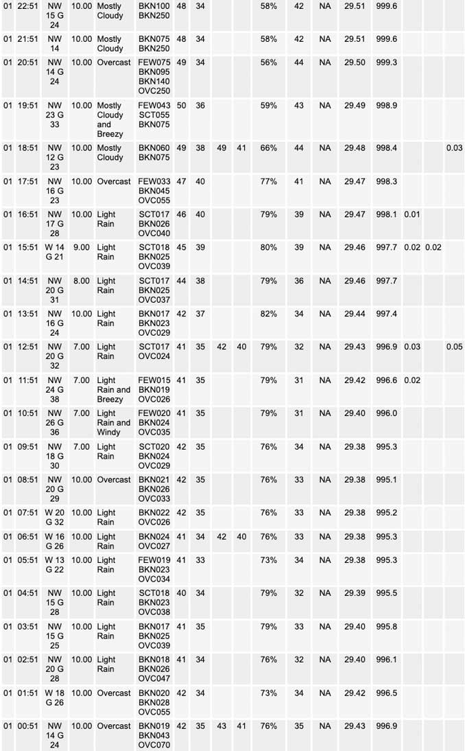
Water vapor imagery early this morning depicts our next notable vort max, and associated mid-level speed max, currently pinwheeling southward across Lake Michigan along the western periphery of the upper low centered over Lower Michigan. This feature will track southward across northeastern parts of IL into northwestern IN through the morning, and is expected to result in another fairly steady round of rain today, especially for eastern sections of the area along and east of the Fox Valley in northern IL, and much of northwestern IN. Rain chances drop quickly with west and southward extent across northern into central IL, where little to no rain is likely. Where it does rain in eastern sections of the area today, it is likely to persist for much of the day before shifting out of the area into this evening.
While much of the precipitation today will fall as a cold rain as temperatures warm into the lower 40s through the morning, a short 2 to 4 hour window exists early this morning in which wet-bulb zero heights will become sufficiently low (under a 1,000 ft AGL) enough to support the possibility for some wet snow flakes. This potential looks to be the best for areas of northeastern IL north of I-88. No accumulation is anticipated.
Temperatures today are expected to remain chilly, especially in eastern sections of the area where it is expected to rain for most of the day. However, western and southwestern sections of the area look to see some slightly warmer conditions this afternoon as mainly dry weather persists. We are thus likely to see high temperatures today range from the low to mid 40s across far northeastern IL and northwestern IN, to the lower 50s along and west of I-39.
Northwesterly winds are also expected to be notably strong and gusty today as the surface gradient continues to strengthen in response to the sub 985 MB surface low pinwheeling west- northwesterly into southeastern Ontario this afternoon. The strongest winds are expected to be across western sections of the area, where deeper mixing outside the persistent area of rain is likely to yield wind gusts of 40 to 45 mph this afternoon. Farther to the east, however, more persistent rain and shallower mixing will likely limit wind gusts to around 35 mph.
Breezy, cool and primarily cloudy weather continues on Tuesday as the upper low begins to slowly migrate over the eastern Lakes Region. Another mid-level impulse is expected to drop southward across the area, an this may result in a few widely scattered afternoon showers Tuesday afternoon. However, this does not look to be a persistent rain event. Expect temperatures to be a hair warmer than those of today, with readings to around 50 northeast, and into the middle 50s for west and southwest parts of the area.
KJB/NWS Chicago
