
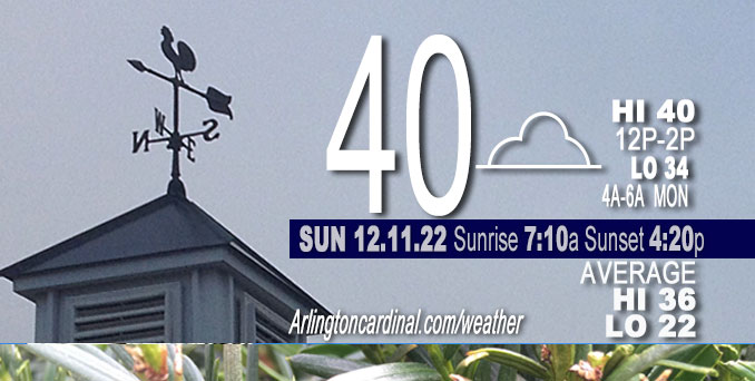
SUNDAY Hi 40, mostly cloudy, winds NW to NE to NNW, 6 to 3 MPH
NWS CHGO | NWS HRLY | /NWSchicago | 🌡
ARLINGTON HEIGHTS WEATHER
▴ forecast7 (Arl. Hts.) | RADAR | WIDE RADAR
⏪ Hrly Data Table | Hrly Future Graph ⏩
IMPORTANT NOTE ON NWS DATA
⏪ Hrly Data Table | Hrly Future Graph ⏩
======================
Sunday and Sunday Night …
No Weather Hazards expected…
In the 7-day outlook, there is no forecast below freezing until early Friday morning (Dec. 16, 2022).
DISCUSSION…
A subsidence inversion continues to trap the lower level cloud cover across the area on Sunday, making for another cloudy day. Fortunately, the threat of drizzle will end by daybreak as cloud depths decrease under a lowering inversion. Drizzle probably won’t return until about midnight Sunday/Monday.
Hello mobile users! If you encounter mobile “unfriendly” weather page, turn your phone sideways for a better view.
======================
O’HARE FORECAST …
Forecast Beginning Sunday, Dec. 11, 2022
Sunday: Patchy drizzle before 10am. Cloudy, with a high near 40. Northwest wind around 5 mph.
Sunday Night: A 20 percent chance of showers or drizzle after midnight. Cloudy, with a low around 34. North wind around 5 mph.
Monday: Mostly cloudy, with a high near 42. East wind 5 to 10 mph.
Monday Night: Mostly cloudy, with a low around 32. East southeast wind around 10 mph, with gusts as high as 15 mph.
Tuesday: A 20 percent chance of rain after 3pm. Mostly cloudy, with a high near 43. Breezy, with an east southeast wind 15 to 20 mph, with gusts as high as 30 mph.
Tuesday Night: Rain, mainly after 9pm. Low around 38. Chance of precipitation is 100%.
Wednesday: Rain likely, mainly before noon. Mostly cloudy, with a high near 48. Chance of precipitation is 70%.
Wednesday Night: A chance of rain before midnight, then a chance of rain and snow. Mostly cloudy, with a low around 36.
Thursday: A chance of rain and snow. Mostly cloudy, with a high near 41.
Thursday Night: A chance of rain and snow before midnight, then a chance of snow. Mostly cloudy, with a low around 31.
Friday: A chance of snow. Mostly cloudy, with a high near 38.
Friday Night: Mostly cloudy, with a low around 28.
Saturday: Mostly cloudy, with a high near 34.


CHICAGOWEATHERSTATION.COM

ChicagoWeatherStation.com I O’Hare Normal Temps/Precip I O’Hare Record Temps, Precip, Snow
LIVE RADAR | STORM TRACKS | UNISYS US IR SAT | UNISYS Midwest IR SAT | UNISYS More IR SAT
WunderMap® with Temperature/Wind Data || Google: Arlington Heights Area Temps | US TEMPS
Full Screen Motion Weather Radar (Wunderground.com)
Midwest Cloud Cover with Arlington Heights Weather Forecast
ChicagoWeatherStation.com I O’Hare Normal Temps/Precip I O’Hare Record Temps, Precip, Snow
SUNLIGHT DATA FOR SECURITY, TRAFFIC SAFETY, AND SPORTS
SunCalc.net data with solar azimuth and trajectory, times for dawn, sunrise, solar noon, sunset, dusk …
NIGHT SKY THIS MONTH …
Backyard stargazers get a monthly guide to the northern hemisphere’s skywatching events with “Tonight’s Sky.” Check the night sky objects for this month and past months in the playlist from the Space Telescope Science Institute YouTube channel (Musical track The Far River written by Jonn Serrie, from the album And the Stars Go With You courtesy of New World Music Ltd).
Get updates from The Cardinal ALL NEWS FEEDS on Facebook. Just ‘LIKE’ the ‘Arlington Cardinal Page (become a fan of our page). The updates cover all posts and sub-category posts from The Cardinal — Arlingtoncardinal.com. You can also limit feeds to specific categories. See all of The Cardinal Facebook fan pages at Arlingtoncardinal.com/about/facebook …
Help fund The Cardinal Arlingtoncardinal.com/sponsor
Area Forecast Discussion
National Weather Service Chicago/Romeoville, IL
548 AM CST Sun Dec 11 2022
.SHORT TERM… Issued at 215 AM CST Sun Dec 11 2022
Through Monday…
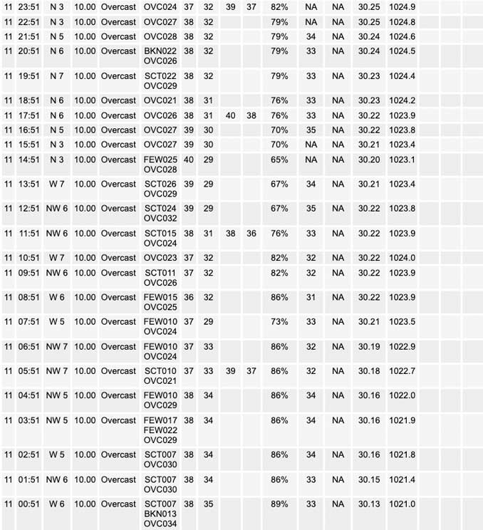
Visibilities continue to improve across the area early this morning, so we will be able to end the lingering dense fog advisory prior to its 4am expiration time. While this is the case, a subsidence inversion will continue to trap the lower level cloud cover across the area today, making for another cloudy day. Fortunately, it appears the threat of drizzle will end by daybreak as cloud depths decrease under a lowering inversion. This should thus result in primarily a precipitation free day for most areas through the day.
Light northwesterly winds will turn north-northeasterly into tonight, as a weak inverted surface trough shifts down the southern end of Lake Michigan. This feature may induce a few light showers or areas of drizzle across the southwestern shores of Lake Michigan tonight into early Monday morning, though inversion heights (and convective cloud depths) look to remain limited to 4,000 ft or less, which does cast some doubt as to how much shower activity there will be with this feature. Nevertheless, I felt it worthwhile to introduce some slight chance (20%) probabilities for a few light showers and/or drizzle along the near shore areas of northeastern IL and northwestern IN tonight, especially considering that a lot of guidance members suggest this potential. Temperatures near the lake are once again expected to remain above freezing tonight so freezing precipitation is not expected to be a problem.
Aside from any lingering light showers or drizzle early Monday morning near the lake, Monday is shaping up to be a precipitation free day across the area. It looks questionable of if we will be able to scour out the persistent low-level cloud cover on Monday as the flow turns easterly in advance of our next storm system taking shape over the Plains. For this reason, it is likely to be another mainly cloudy day with high temperatures in the lower 40s.
KJB/NWS Chicago
