
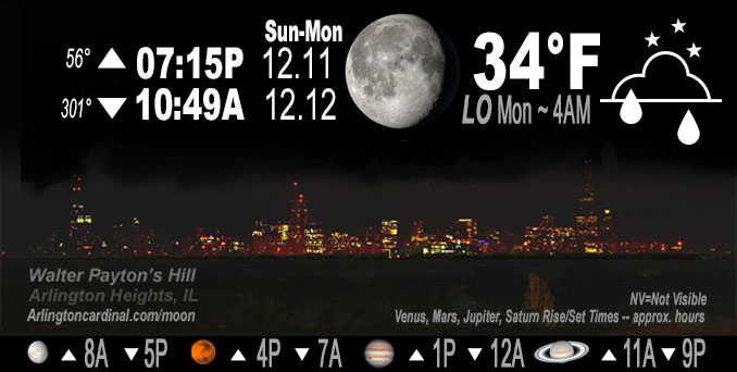
🌖 🌗 🌑 🌓 Waning Gibbous Moon, sky cover overnight Sun. to Mon. 100% to 92%, winds N to NNE to NE, 5 to 6 MPH, Low 34, 4a to 7a
NWS CHGO | NWS HRLY | /NWSchicago | 🌡
ARLINGTON HEIGHTS WEATHER
▴ forecast7 (Arl. Hts.) | RADAR | WIDE RADAR
IMPORTANT NOTE ON NWS DATA
======================
Overnight Sunday/Monday …
No Weather Hazards expected…
DISCUSSION…
Areas of drizzle possible overnight into Monday morning near the lake. Temperatures are expected to remain above freezing near Lake Michigan in Arlington Heights and the northwest suburbs Monday morning, but might hit 32°F in Arlington Heights and the northwest suburbs early Tuesday morning. Then morning lows will be well above freezing Wednesday morning and Thursday morning (Dec. 15). The normal lows for Dec. 12 through Dec. 15 are 21°F. The long range forecast doesn’t foresee a normal low (20°F) until Saturday morning (Dec. 17, 2022)
Expansive cloud cover and light northwesterly flow have held down temperatures below 40 for many areas of Chicagoland on Sunday resulting in another cloudy and cool day across Chicagoland. O’Hare did reach 40°F, however. Other than some patchy drizzle into far northeastern Porter County, the rest of the area should stayed precip free through the rest of Sunday afternoon and is expected to be precip free Sunday evening. Widespread cloud cover continuing overnight will again limit our cooling with temperatures remaining in the mid 30s in the Chicago metro and near the lake with lower 30s expected further inland.
As winds begin to trend more north and northeasterly this evening there is the potential for more drizzle to push inland off the lake after midnight tonight into portions of the Chicago metro, especially for areas nearest the lake. The drizzle may persist through the morning hours on Monday as well.
Hello mobile users! If you encounter mobile “unfriendly” weather page, turn your phone sideways for a better view.
======================
O’HARE FORECAST …
Forecast Beginning Sunday Night, Dec. 11, 2022 …
Sunday Night: Areas of drizzle with a slight chance of showers after 4am. Cloudy, with a low around 34. North wind around 5 mph.
Monday: Areas of drizzle with a slight chance of showers before 11am. Cloudy, with a high near 41. North northeast wind 5 to 10 mph becoming east in the afternoon.
Monday Night: Mostly cloudy, with a low around 32. East southeast wind around 10 mph, with gusts as high as 15 mph.
Tuesday: Mostly cloudy, with a high near 40. Breezy, with an east southeast wind 10 to 20 mph, with gusts as high as 30 mph.
Tuesday Night: Rain. Low around 38. Breezy, with an east southeast wind around 20 mph, with gusts as high as 35 mph. Chance of precipitation is 100%.
Wednesday: Rain, mainly before noon. High near 48. Breezy. Chance of precipitation is 80%.
Wednesday Night: A 50 percent chance of rain. Mostly cloudy, with a low around 37.
Thursday: A chance of rain. Mostly cloudy, with a high near 42.
Thursday Night: A chance of rain and snow before midnight, then a chance of snow. Mostly cloudy, with a low around 31.
Friday: A chance of snow. Mostly cloudy, with a high near 36.
Friday Night: A chance of snow. Mostly cloudy, with a low around 24.
Saturday: Mostly cloudy, with a high near 31.
Saturday Night: Mostly cloudy, with a low around 20.
Sunday: Partly sunny, with a high near 29.
O’Hare forecast archive and hourly weather observations archive are available HERE on the CARDINAL NEWS Magazine.
Arlingtoncardinal.com/moonphases
Arlingtoncardinal.com/nightsky
NIGHT SKY THIS MONTH …
Check the night sky objects for this month and past months in the playlist from the Space Telescope Science Institute YouTube channel Backyard stargazers get a monthly guide to the northern hemisphere’s skywatching events with “Tonight’s Sky” (Musical track The Far River written by Jonn Serrie, from the album And the Stars Go With You courtesy of New World Music Ltd. Musical track The Far River written by Jonn Serrie, from the album And the Stars Go With You courtesy of New World Music Ltd).
Telephoto lens, ISO 100, f/11, Shutter Speed 1/100 to 1/125 for the Moon.
Get updates from The Cardinal ALL NEWS FEEDS on Facebook. Just ‘LIKE’ the ‘Arlington Cardinal Page (become a fan of our page). The updates cover all posts and sub-category posts from The Cardinal — Arlingtoncardinal.com. You can also limit feeds to specific categories. See all of The Cardinal Facebook fan pages at Arlingtoncardinal.com/about/facebook …
Help fund The Cardinal Arlingtoncardinal.com/sponsor
Telephoto lens, ISO 1600, f/11, Shutter Speed 2.5″ for the skyline. The skyline exposure was toned down, and brightness and contrast was adjusted in Photoshop.
Area Forecast Discussion
National Weather Service Chicago/Romeoville, IL
535 PM CST Sun Dec 11 2022
.SHORT TERM… Issued at 214 PM CST Sun Dec 11 2022
Through Monday night…
Key Message in the short term:
1. Areas of drizzle possible overnight into Monday AM near the lake (temps to remain above freezing in those locales)
Expansive cloud cover and light northwesterly flow have held down temperatures below 40 so far today making for another cloudy and cool day across Chicagoland. Other than some patchy drizzle into far northeastern Porter County, the rest of the area should stay precip free through the rest of the afternoon and evening. Widespread cloud cover continuing overnight will again limit our cooling with temperatures remaining in the mid 30s in the Chicago metro and near the lake with lower 30s expected further inland.
As winds begin to trend more north northeasterly this evening there is the potential for more drizzle to push inland off the lake after midnight tonight into portions of the Chicago metro, especially for areas nearest the lake. The drizzle may persist through the morning hours on Monday as well. Lake induced equilibrium levels are fairly shallow suggesting the majority of this is expected to be drizzle, but a few spotty showers cannot be ruled out. Will also note that the HRRR is the most bullish with QPF up to 0.05-0.10″ with this activity. Temperatures near the lake and where any precipitation falls are expected to remain above freezing. Accordingly the concern for any icing remains low. Further inland should remain mainly dry through the period, though some patchy drizzle cannot be ruled out Monday morning. Overall, tomorrow looks like a repeat of today with cool and cloudy conditions and highs in the upper 30s to around 40 degrees.
Petr/NWS Chicago
