
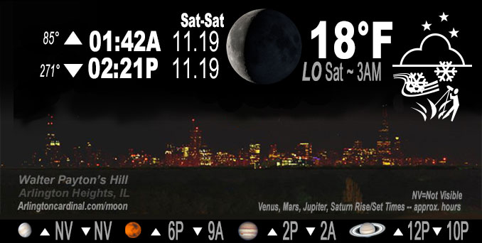
🌘 🌑 🌗 🌕 Waning Crescent Moon, sky cover overnight Fri. to Sat. 87% to 51% to 75%, winds WSW to SW, 16 to 15 to 17 MPH, G25 to 23 to 30 MPH, Low 18, 3a to 6a
NWS CHGO | NWS HRLY | /NWSchicago | 🌡
ARLINGTON HEIGHTS WEATHER
▴ forecast7 (Arl. Hts.) | RADAR | WIDE RADAR
IMPORTANT NOTE ON NWS DATA
======================
Friday Night …
Weather hazards expected…
Limited Snow Risk through early Friday evening.
Limited Non Thunderstorm Wind Risk Saturday
Limited Snow Risk Saturday
Limited Excessive Cold Risk Saturday Night/Sunday Morning
DISCUSSION…
Scattered snow showers are likely again Saturday. With westerly winds gusting to 35 mph, significant reductions in visibility are likely under the strongest snow showers. A quick coating to an inch of snow is possible in some areas.
Sub-zero wind chills are expected late Saturday night into early Sunday morning.
Hello mobile users! If you encounter mobile “unfriendly” weather page, turn your phone sideways for a better view.
======================
O’HARE FORECAST …
Forecast Beginning Friday Night, Nov. 18, 2022
Friday Night: Scattered flurries before midnight. Mostly cloudy, with a low around 18. West southwest wind around 15 mph, with gusts as high as 25 mph.
Saturday: Scattered flurries before 9am, then scattered snow showers after 9am. Mostly cloudy, with a high near 27. Breezy, with a south southwest wind 15 to 25 mph becoming west northwest in the afternoon. Winds could gust as high as 35 mph. Chance of precipitation is 40%.
Saturday Night: Partly cloudy, with a low around 11. Wind chill values as low as -3. Blustery, with a west northwest wind 10 to 20 mph, with gusts as high as 30 mph.
Sunday: Sunny, with a high near 31. Wind chill values as low as zero. West southwest wind 10 to 15 mph, with gusts as high as 25 mph.
Sunday Night: Partly cloudy, with a low around 27. South southwest wind around 15 mph, with gusts as high as 30 mph.
Monday: Sunny, with a high near 43.
Monday Night: Mostly clear, with a low around 24.
Tuesday: Sunny, with a high near 46.
Tuesday Night: Partly cloudy, with a low around 32.
Wednesday: Partly sunny, with a high near 48.
Wednesday Night: Mostly cloudy, with a low around 37.
Thanksgiving Day: A chance of rain. Partly sunny, with a high near 45.
Thursday Night: A chance of rain and snow. Mostly cloudy, with a low around 31.
Friday: Partly sunny, with a high near 41.
O’Hare forecast archive and hourly weather observations archive are available HERE on the CARDINAL NEWS Magazine.
Arlingtoncardinal.com/moonphases
Arlingtoncardinal.com/nightsky
NIGHT SKY THIS MONTH …
Check the night sky objects for this month and past months in the playlist from the Space Telescope Science Institute YouTube channel Backyard stargazers get a monthly guide to the northern hemisphere’s skywatching events with “Tonight’s Sky” (Musical track The Far River written by Jonn Serrie, from the album And the Stars Go With You courtesy of New World Music Ltd. Musical track The Far River written by Jonn Serrie, from the album And the Stars Go With You courtesy of New World Music Ltd).
Telephoto lens, ISO 100, f/11, Shutter Speed 1/100 to 1/125 for the Moon.
Get updates from The Cardinal ALL NEWS FEEDS on Facebook. Just ‘LIKE’ the ‘Arlington Cardinal Page (become a fan of our page). The updates cover all posts and sub-category posts from The Cardinal — Arlingtoncardinal.com. You can also limit feeds to specific categories. See all of The Cardinal Facebook fan pages at Arlingtoncardinal.com/about/facebook …
Help fund The Cardinal Arlingtoncardinal.com/sponsor
Telephoto lens, ISO 1600, f/11, Shutter Speed 2.5″ for the skyline. The skyline exposure was toned down, and brightness and contrast was adjusted in Photoshop.
Area Forecast Discussion
National Weather Service Chicago/Romeoville, IL
541 PM CST Fri Nov 18 2022
.SHORT TERM… Issued at 242 PM CST Fri Nov 18 2022
Through Saturday night…
The ongoing intermittent flurries and scattered snow showers will continue through this evening as an upper-level disturbance moves through the area. Forecast soundings have continued to show strong low-level lapse rates on the order of 6 to 7 C/km across the area this afternoon which may allow for the development of a couple of more robust snow showers through this evening. These stronger showers would be capable of producing hefty snowfall rates which would lead to sharply reduced visibilities and minor accumulations on roads and bridges causing slowed travel. Otherwise, the lighter snow showers and flurries are expected to cause little to no accumulation through tonight. The snow showers will gradually come to an end this evening as drier air begins to filter into the DGZ from the west. This will leave us under dry, but blustery conditions for the overnight hours and into our Saturday morning. Temperatures are expected to drop into the mid to upper teens tonight with 20 mph wind gusts causing wind chills in the low single digits to near zero to start of our Saturday.
Saturday will see similar conditions to what we have seen today, but with slightly stronger winds gusting around 30 mph during the afternoon. Another upper-level disturbance is expected to move across the southern Great Lakes region Saturday afternoon which will set the stage of scattered flurries and snow showers as a layer of moisture around 850 mb move in with an elevated front. This moisture should be sufficient to produce scattered flurries and snow showers from mid morning through late afternoon with a potential for some stronger showers and/or snow squalls to develop as better low-level instability develops during the afternoon and early evening. Guidance continues to be very spotty in coverage of these showers with the best potential looking to be closer to the upper-level disturbance over northern Illinois and southern Wisconsin where I have maintained the highest precipitation chances. Regardless, the majority of these showers should lead to little or no accumulation but should the stronger showers or squalls develop locally high amounts up to one inch may be realized which could lead to slowed travel in these spots.
Once the upper-level disturbance moves east of the area Saturday evening, snow showers and flurries will come to an end with winds gradually easing through the night as well. However, temperatures will still be cold with lows expected to dip into the lower teens and single digits Saturday night with wind chills around and just below zero degrees.
Yack/NWS Chicago
