
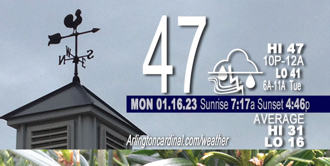
Monday Hi 47, cloudy, light rain, chance thundershower 7p, winds SSE to S to SW, 17 to 11 to 13 MPH, G24 to 29 to 23 MPH
NWS CHGO | NWS HRLY | /NWSchicago | 🌡
ARLINGTON HEIGHTS WEATHER
▴ forecast7 (Arl. Hts.) | RADAR | WIDE RADAR
⏪ Hrly Data Table | Hrly Future Graph ⏩
IMPORTANT NOTE ON NWS DATA
⏪ Hrly Data Table | Hrly Future Graph ⏩
======================
Monday and Monday Night …
Weather Hazards expected …
Limited Thunderstorm Risk (7:00 p.m. to 8:00 p.m. in Arlington Heights and nearby communities).
DISCUSSION…
A few thunderstorms are possible Monday afternoon and evening. Some could produce small hail and gusty winds.
When using forecast highs and lows for both Monday (today) and Tuesday (tomorrow) to determine forecast daily average temperatures, it appears the first 17 days of January could turn out to produce an average that becomes the second warmest on record at both Chicago and Rockford — though much will depend on temperatures right at midnight Monday/Tuesday.
======================
O’HARE FORECAST …
MIDWAY — problem with NWS O’Hare
Forecast Beginning Monday, Jan. 16, 2023
M.L.King Day: Showers, mainly before 3pm. High near 46. South wind around 15 mph, with gusts as high as 30 mph. Chance of precipitation is 100%. New precipitation amounts between a tenth and quarter of an inch possible.
Monday Night: Scattered showers and thunderstorms before 9pm, then isolated showers between 9pm and 10pm. Mostly cloudy, with a low around 40. Southwest wind 10 to 15 mph, with gusts as high as 25 mph. Chance of precipitation is 40%.
Tuesday: Isolated showers before noon. Cloudy, with a high near 42. West southwest wind 10 to 15 mph, with gusts as high as 30 mph. Chance of precipitation is 20%.
Tuesday Night: Mostly cloudy, with a low around 32. West wind 5 to 15 mph, with gusts as high as 25 mph.
Wednesday: A 20 percent chance of rain after 3pm. Mostly cloudy, with a high near 40. West northwest wind 5 to 10 mph becoming east northeast in the afternoon.
Wednesday Night: Rain. Low around 35. Chance of precipitation is 90%.
Thursday: Rain likely before noon, then a chance of rain and snow. Cloudy, with a high near 40. Chance of precipitation is 60%.
Thursday Night: Cloudy, with a low around 28.
Friday: Mostly cloudy, with a high near 35.
Friday Night: Mostly cloudy, with a low around 25.
Saturday: Mostly cloudy, with a high near 34.
Saturday Night: Mostly cloudy, with a low around 27.
Sunday: Partly sunny, with a high near 38.


CHICAGOWEATHERSTATION.COM

ChicagoWeatherStation.com I O’Hare Normal Temps/Precip I O’Hare Record Temps, Precip, Snow
LIVE RADAR | STORM TRACKS | UNISYS US IR SAT | UNISYS Midwest IR SAT | UNISYS More IR SAT
WunderMap® with Temperature/Wind Data || Google: Arlington Heights Area Temps | US TEMPS
Full Screen Motion Weather Radar (Wunderground.com)
Midwest Cloud Cover with Arlington Heights Weather Forecast
ChicagoWeatherStation.com I O’Hare Normal Temps/Precip I O’Hare Record Temps, Precip, Snow
SUNLIGHT DATA FOR SECURITY, TRAFFIC SAFETY, AND SPORTS
SunCalc.net data with solar azimuth and trajectory, times for dawn, sunrise, solar noon, sunset, dusk …
NIGHT SKY THIS MONTH …
Backyard stargazers get a monthly guide to the northern hemisphere’s skywatching events with “Tonight’s Sky.” Check the night sky objects for this month and past months in the playlist from the Space Telescope Science Institute YouTube channel (Musical track The Far River written by Jonn Serrie, from the album And the Stars Go With You courtesy of New World Music Ltd).
Get updates from The Cardinal ALL NEWS FEEDS on Facebook. Just ‘LIKE’ the ‘Arlington Cardinal Page (become a fan of our page). The updates cover all posts and sub-category posts from The Cardinal — Arlingtoncardinal.com. You can also limit feeds to specific categories. See all of The Cardinal Facebook fan pages at Arlingtoncardinal.com/about/facebook …
Help fund The Cardinal Arlingtoncardinal.com/sponsor
Area Forecast Discussion
National Weather Service Chicago/Romeoville, IL
551 AM CST Mon Jan 16 2023
.SHORT TERM… Issued at 147 AM CST Mon Jan 16 2023
Through Tuesday…
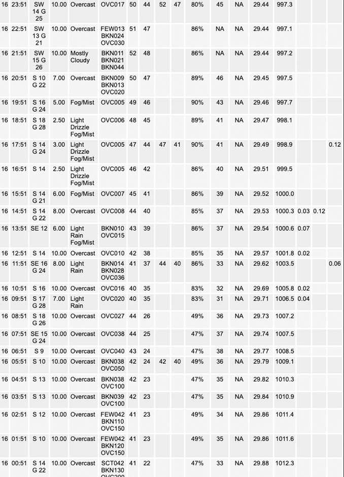
A recent hand surface analysis places a 994 mb surface low pressure system in central Kansas and a northward-expanding warm sector across the mid-Mississippi River Valley. Water vapor imagery shows the position of the low nicely with the look of an increasingly wound up cinnamon roll. (Breakfast is apparently on our minds this morning). Ahead of the low, extensive radar returns are spreading northeastward, though surface observations have shown little to no precipitation reaching the ground owing to low-level dry layer sampled from about 5000-15000ft per recent AMDAR soundings. Temperatures at press time are relatively warm if not balmy for this time of year with readings ranging from the upper 30s to lower 40s.
Over the next 6 to 12 hours, low-to mid-level warm air and moisture advection will spread into the Mississippi River Valley as the surface low lifts into southwestern Iowa. As a result, radar returns are expected increase in coverage and intensity toward and especially after daybreak. Today accordingly looks wet with waves of showers from mid-morning to early-afternoon areawide. A brief lull in shower activity appears possible from late afternoon to early evening before a final band of scattered showers along a northeastward-moving cold front arcs through the area after sunset. A thunderstorm or two may accompany the showers along the cold front as 850-500mb lapse rates steepen to 7 K/km and surface dew points rise to 45-50F, supporting a narrow axis of 200-300 J/kg of MUCAPE with ELs from -15 to -20C.
Outside of the waves of showers and winds, temperatures today will be well above average with highs in the upper 40s and even lower 50s. The warmest readings appear likely after dark given the cold front is expected to sweep across the area toward midnight. As a result, the unseasonably warm air may “double dip” from a daily climate perspective and contribute on paper to the impressive run of much above-average temperatures to start the year. When using forecast highs and lows for both today and tomorrow to inform forecast daily average temperatures, it appears the first 17 days of January will have the opportunity to slide into the 2nd warmest on record at both Chicago and Rockford though much will depend on temperatures right at midnight tonight.
One final item for today – south to southeasterly winds will become breezy this morning in response to the tightening low-level pressure gradient. In spite of 45-50kt of low-level flow about 2000 feet AGL, a strong low-level inversion will curtail mixing depths with winds instead largely driven by the low-level pressure gradient itself.
Tuesday will feel notably cooler than today with breezy westerly winds (at times gusting over 30 mph) and overcast skies. A few sprinkles or snowflakes cannot be ruled out during the morning hours near the Wisconsin State line.
Borchardt/NWS Chicago
