
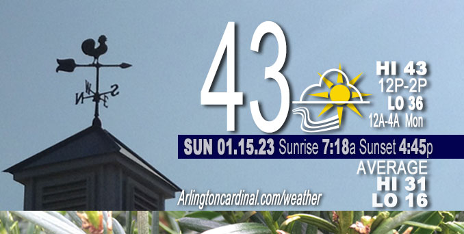
Sunday Hi 43, partly sunny, winds S to SSE, 8 to 15 MPH, G16 to 29 to 23 MPH
NWS CHGO | NWS HRLY | /NWSchicago | 🌡
ARLINGTON HEIGHTS WEATHER
▴ forecast7 (Arl. Hts.) | RADAR | WIDE RADAR
⏪ Hrly Data Table | Hrly Future Graph ⏩
IMPORTANT NOTE ON NWS DATA
⏪ Hrly Data Table | Hrly Future Graph ⏩
======================
Sunday and Sunday Night …
No Weather Hazards expected …
A period of light rain will arrive after 2:00 a.m. and will continue all day Monday with a little of one-quarter inch by late Monday night.
DISCUSSION…
Regional water vapor imagery depicts extensive high clouds across the Mississippi River Valley within an eastward-propagating upper-level ridge. Upper-level troughs flank both sides of the ridge, with a deepening Atlantic low off the coast of Virginia and yet another Pacific storm system impacting California. However, all is quiet in Chicagoland thanks to deep subsidence provided by the ridge over the Mississippi River Valley, which is maintaining a stout low-level inversion over northern Illinois and northwestern Indiana.
With the ridge only slowly propagating eastward today, generally quiet conditions are expected across our area with periods of high clouds and temperatures around the 40 degree mark.
======================
O’HARE FORECAST …
MIDWAY — problem with NWS O’Hare
Forecast Beginning Sunday, Jan. 15, 2023
Sunday: Partly sunny, with a high near 41. South wind 10 to 15 mph, with gusts as high as 30 mph.
Sunday Night: Rain likely, mainly after 3am. Cloudy, with a low around 38. South southeast wind around 15 mph, with gusts as high as 30 mph. Chance of precipitation is 60%.
M.L.King Day: Rain before noon, then rain and possibly a thunderstorm between noon and 3pm, then rain after 3pm. High near 47. South southeast wind around 15 mph, with gusts as high as 30 mph. Chance of precipitation is 100%. New rainfall amounts between a quarter and half of an inch possible.
Monday Night: A 40 percent chance of rain before midnight. Mostly cloudy, with a low around 40. South wind 10 to 15 mph becoming west southwest after midnight. Winds could gust as high as 25 mph.
Tuesday: A 20 percent chance of showers. Mostly cloudy, with a high near 43. West wind around 15 mph, with gusts as high as 25 mph.
Tuesday Night: Mostly cloudy, with a low around 33.
Wednesday:Mostly cloudy, with a high near 39.
Wednesday Night: Snow likely after midnight. Cloudy, with a low around 34.
Thursday: Snow. Cloudy, with a high near 36.
Thursday Night: Mostly cloudy, with a low around 27.
Friday: Mostly cloudy, with a high near 33.
Friday Night: Mostly cloudy, with a low around 26.
Saturday: Mostly cloudy, with a high near 34.


CHICAGOWEATHERSTATION.COM

ChicagoWeatherStation.com I O’Hare Normal Temps/Precip I O’Hare Record Temps, Precip, Snow
LIVE RADAR | STORM TRACKS | UNISYS US IR SAT | UNISYS Midwest IR SAT | UNISYS More IR SAT
WunderMap® with Temperature/Wind Data || Google: Arlington Heights Area Temps | US TEMPS
Full Screen Motion Weather Radar (Wunderground.com)
Midwest Cloud Cover with Arlington Heights Weather Forecast
ChicagoWeatherStation.com I O’Hare Normal Temps/Precip I O’Hare Record Temps, Precip, Snow
SUNLIGHT DATA FOR SECURITY, TRAFFIC SAFETY, AND SPORTS
SunCalc.net data with solar azimuth and trajectory, times for dawn, sunrise, solar noon, sunset, dusk …
NIGHT SKY THIS MONTH …
Backyard stargazers get a monthly guide to the northern hemisphere’s skywatching events with “Tonight’s Sky.” Check the night sky objects for this month and past months in the playlist from the Space Telescope Science Institute YouTube channel (Musical track The Far River written by Jonn Serrie, from the album And the Stars Go With You courtesy of New World Music Ltd).
Get updates from The Cardinal ALL NEWS FEEDS on Facebook. Just ‘LIKE’ the ‘Arlington Cardinal Page (become a fan of our page). The updates cover all posts and sub-category posts from The Cardinal — Arlingtoncardinal.com. You can also limit feeds to specific categories. See all of The Cardinal Facebook fan pages at Arlingtoncardinal.com/about/facebook …
Help fund The Cardinal Arlingtoncardinal.com/sponsor
Area Forecast Discussion
National Weather Service Chicago/Romeoville, IL
527 AM CST Sun Jan 15 2023
.SHORT TERM… Issued at 154 AM CST Sun Jan 15 2023
Through Monday night…
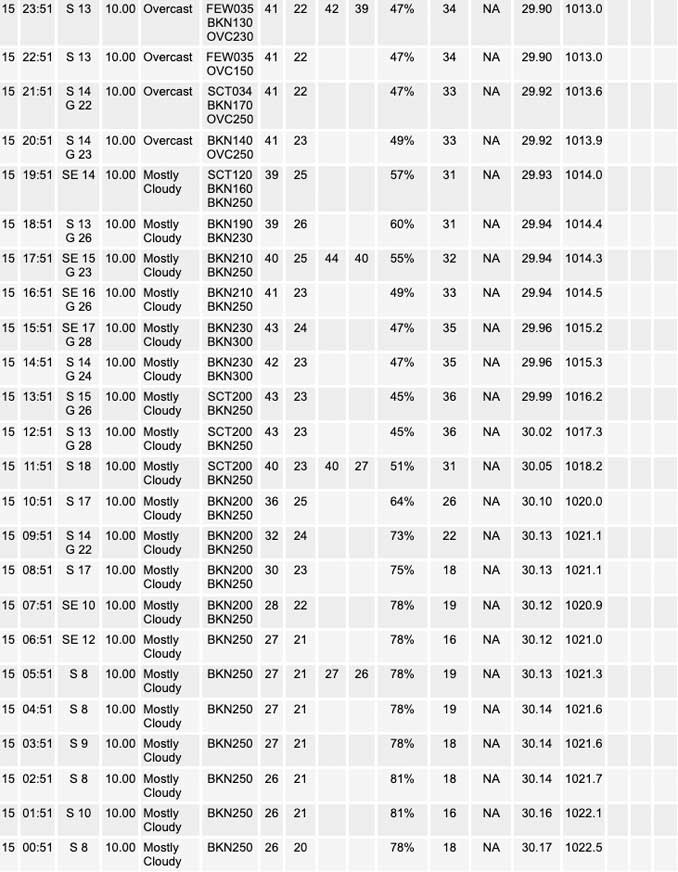
Regional water vapor imagery depicts extensive high clouds across the Mississippi River Valley within an eastward-propagating upper-level ridge. Upper-level troughs flank both sides of the ridge, with a deepening Atlantic low off the coast of Virginia and yet another Pacific storm system impacting California. All is quiet locally thanks to deep subsidence provided by the aforementioned ridge, which is maintaining a stout low-level inversion over northern Illinois and northwestern Indiana. Surface winds are accordingly light and temperatures range from the mid to upper 20s.
With the ridge only slowly propagating eastward today, generally quiet conditions are expected across our area with periods of high clouds and temperatures around the 40 degree mark. This afternoon, the Pacific trough will dig across the Four Corners Region leading to surface pressure falls and eventually lee cyclogenesis across the Plains. As a result, the low-level pressure gradient across the Mississippi River Valley will gradually tighten this afternoon leading to breezy south to southeasterly winds. Wind chills this afternoon will remain close to the freezing mark this afternoon in spite of above-average highs.
Tonight and Monday, the surface low pressure system is expected to lift generally along a path from Wichita, Kansas to Cedar Rapids, Iowa. As the low approaches tonight, gradually increasing low-level warm-air advection will support a blossoming area of rain showers that will spread northeast into our area toward daybreak Monday. In fact, much of Monday morning looks like a washout with waves of showers throughout the day. As 850-500mb lapse rates steepen to 7K/km Monday afternoon atop a stout low-level inversion, a few elevated thunderstorms cannot be ruled out primarily in Illinois with the main threat for small, non-damaging hail, a lightning strike or two, and locally heavier downpours. As the low approaches, south to southeasterly winds will also increase in magnitude, though gusts look to remain at or below 30 mph as mixing into the base of the LLJ is stunted by the low-level inversion.
We`ll have to keep an eye on a localized severe weather threat Monday evening (4-8 pm) west of I-39 as a plume of 45-50 degree surface dew points interacts with the aforementioned plume of 7 K/km 850-500mb lapse rates to generate a narrow axis of 300-500 of MLCAPE ahead of a northeastward-moving cold front. Considering the low-level wind field will be strong and sheared with 20-25kt of 0-500m shear oriented orthogonal to the front, a band of low- topped supercells cannot be ruled out with a localized threat for 1″ hail (e.g. low freezing levels) and winds strong enough to down a tree branch or two (e.g. mixing down the strong low-level wind field). The threat for a repeat of January 3 with a cluster of tornadoes appears low (2% or less) owing to meager low-level instability. (A crude rule of thumb for cold season tornadoes in our area is that surface dew points need to be at least 60F. Forecast dew points Monday evening are well below that). Nevertheless, the threat for an arcing band of low-topped supercells cannot be ignored and is highest from eastern Iowa to perhaps far western Illinois. The area outlined in the SPC Day 2 threat level 1/5 outlook area looks good.
Borchardt/NWS Chicago
