
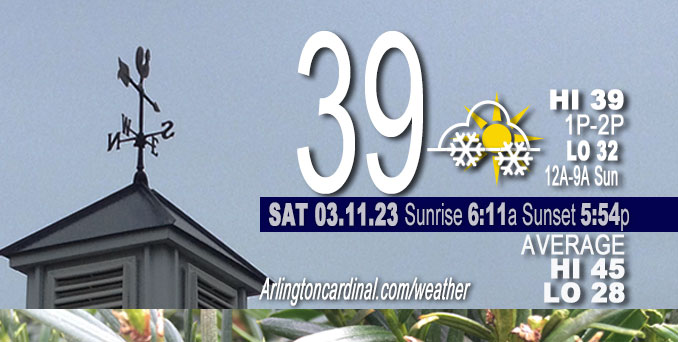
Saturday Hi 39, partly sunny to mostly cloudy, light snow starts 7p, winds ENE to E to ESE, 5 to 9 to 11 to 7 MPH, G13 8p to 9p
NWS CHGO | NWS HRLY | /NWSchicago | 🌡
ARLINGTON HEIGHTS WEATHER
▴ forecast7 (Arl. Hts.) | RADAR | WIDE RADAR
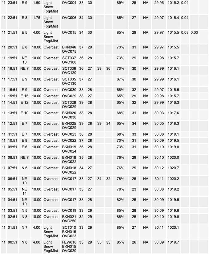
⏪ Hrly Data Table | Hrly Future Graph ⏩
IMPORTANT NOTE ON NWS DATA
⏪ Hrly Data Table | Hrly Future Graph ⏩
Hello mobile users! If you encounter a mobile “unfriendly” weather page, turn your phone sideways for a better view.
======================
Saturday and Saturday Evening …
Weather Hazards expected …
Limited Snow Risk Saturday night to Sunday morning. Snow accumulation expected to be about 1.2″ from 6:00 p.m. Saturday to 12:00 a.m. Monday.
DISCUSSION…
Snow accumulations generally under two inches are expected tonight, with snow developing in the evening and tapering off early Sunday morning. Slushy accumulations are likely on some roads.
Cooler temperatures through early next week then rebounding midweek.
Additional four minutes of daylight on Saturday, March 11, 2023.
======================
O’HARE FORECAST …
Forecast Beginning Saturday, Mar. 11, 2023
Saturday: Cloudy, with a high near 39. East wind 5 to 10 mph.
Saturday Night: A chance of rain and snow between 7pm and 10pm, then snow. Low around 32. East southeast wind 5 to 10 mph. Chance of precipitation is 90%. New snow accumulation of less than one inch possible.
Sunday: Snow showers likely before noon, then scattered rain and snow showers. Cloudy, with a high near 36. East southeast wind 5 to 10 mph becoming west in the afternoon. Winds could gust as high as 15 mph. Chance of precipitation is 70%. New snow accumulation of less than a half inch possible.
Sunday Night: A 40 percent chance of snow showers, mainly before midnight. Mostly cloudy, with a low around 28. West wind around 15 mph, with gusts as high as 25 mph.
Monday: A 20 percent chance of snow showers. Cloudy, with a high near 34. Breezy, with a north northwest wind 15 to 20 mph, with gusts as high as 30 mph.
Monday Night: Partly cloudy, with a low around 20.
Tuesday: Sunny, with a high near 34.
Tuesday Night: Mostly clear, with a low around 21.
Wednesday: Mostly sunny, with a high near 48.
Wednesday Night: Mostly cloudy, with a low around 43.
Thursday: A chance of rain. Mostly cloudy, with a high near 54.
Thursday Night: Rain likely. Cloudy, with a low around 34.
Friday: A chance of rain. Mostly cloudy, with a high near 45. Breezy.


CHICAGOWEATHERSTATION.COM

ChicagoWeatherStation.com I O’Hare Normal Temps/Precip I O’Hare Record Temps, Precip, Snow
LIVE RADAR | STORM TRACKS | UNISYS US IR SAT | UNISYS Midwest IR SAT | UNISYS More IR SAT
WunderMap® with Temperature/Wind Data || Google: Arlington Heights Area Temps | US TEMPS
Full Screen Motion Weather Radar (Wunderground.com)
Midwest Cloud Cover with Arlington Heights Weather Forecast
ChicagoWeatherStation.com I O’Hare Normal Temps/Precip I O’Hare Record Temps, Precip, Snow
SUNLIGHT DATA FOR SECURITY, TRAFFIC SAFETY, AND SPORTS
SunCalc.net data with solar azimuth and trajectory, times for dawn, sunrise, solar noon, sunset, dusk …
NIGHT SKY THIS MONTH …
Backyard stargazers get a monthly guide to the northern hemisphere’s skywatching events with “Tonight’s Sky.” Check the night sky objects for this month and past months in the playlist from the Space Telescope Science Institute YouTube channel (Musical track The Far River written by Jonn Serrie, from the album And the Stars Go With You courtesy of New World Music Ltd).
Get updates from The Cardinal ALL NEWS FEEDS on Facebook. Just ‘LIKE’ the ‘Arlington Cardinal Page (become a fan of our page). The updates cover all posts and sub-category posts from The Cardinal — Arlingtoncardinal.com. You can also limit feeds to specific categories. See all of The Cardinal Facebook fan pages at Arlingtoncardinal.com/about/facebook …
Help fund The Cardinal Arlingtoncardinal.com/sponsor
Area Forecast Discussion
National Weather Service Chicago/Romeoville, IL
532 AM CST Sat Mar 11 2023
.SHORT TERM… Issued at 212 AM CST Sat Mar 11 2023
Through Sunday…
A recent subjective surface analyses places a 1030mb+ surface high pressure system in northern Ontario with a southward extension of a surface ridge through the western Great Lakes. Meanwhile, upper- level satellite imagery depicts a pair of shortwaves propagating across the western US — the first over eastern Colorado and the second (more vigorous of the two) moving over eastern Montana. In fact, much of the CONUS is encompassed beneath some degree of cloud cover early this morning, which is a telltale sign of the winter- like pattern currently gripping North America.
With the aforementioned pair of upper-level shortwaves well to our west and surface ridge sliding through this morning, today looks relatively quiet with mostly cloudy skies, light easterly winds, and temperatures in the upper 30s to lower 40s. As the Colorado shortwave moves into the central Plains this afternoon, increasing low-level warm air advection, compact DCVA, and even filaments of low- to mid-level FGEN will support a burgeoning area of precipitation from southern Minnesota to northern Missouri. The leading edge of precipitation should reach western Illinois toward sunset and then I-39 by 10-11 pm, spreading eastward toward Lake Michigan by midnight. Precipitation type at the onset should be rain but cooling of the low-level thermal provide via evaporation into a residual dry layer should support a transition to snow overnight. Forcing for ascent will quickly weaken though the overnight hours as the shortwave gets sheared apart, suggesting snow rates will taper between midnight and daybreak limiting the opportunity for snow accumulations to get out of hand. Indeed, the forecast for 1 to maybe 2″ of snow remains (and perhaps slushy accumulations on roadways).
After daybreak, nebulous forcing for ascent (some remnant from the sheared-out Colorado shortwave and increasing DCVA from the Montana shortwave approaching from the northwest) should force a transition from widespread, stratiform precipitation to that of a more “showery” nature. In addition, rising surface temperatures thanks to increasing low-level advection ahead of the Montana shortwave will change precipitation type to an un-impactful rain/snow grain mix. So, our expectation is for widely scattered rain/snow showers throughout the day on Sunday with little to no impact. Shower coverage should pick up in the afternoon and especially evening along and behind an eastward-surging cold front. In fact, some sort of snow squall-like feature appears poised to develop over northwestern Indiana along the front, which may look more ominous on radar than in actuality owing to surface temperatures well above freezing (e.g. may just pose a threat for brief reductions in visibility and no threat for actual snow accumulations).
Borchardt/NWS Chicago
