
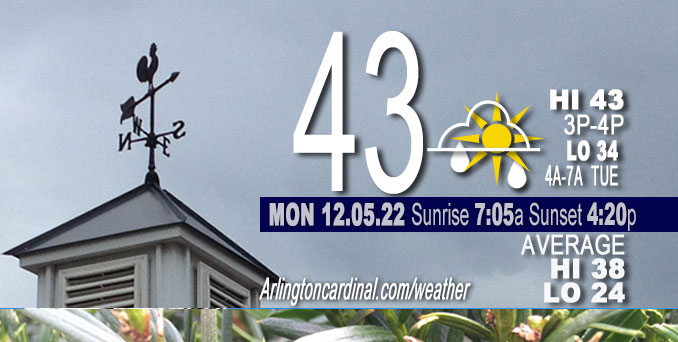
MONDAY Hi 43, mostly cloudy, slight chance drizzle 7p to 10p, winds SW to W to NNW, 10 to 6 MPH
NWS CHGO | NWS HRLY | /NWSchicago | 🌡
ARLINGTON HEIGHTS WEATHER
▴ forecast7 (Arl. Hts.) | RADAR | WIDE RADAR
⏪ Hrly Data Table | Hrly Future Graph ⏩
IMPORTANT NOTE ON NWS DATA
⏪ Hrly Data Table | Hrly Future Graph ⏩
======================
Monday and Monday Night …
No Weather Hazards expected…
DISCUSSION…
The focus on the near-term period will be a couple of periods of light rain/drizzle in the forecast. The first drizzle period will be Monday afternoon/evening mainly across the southeast half of the forecast area and the second later Tuesday afternoon and evening again mainly across the southern areas of Chicagoland. Arlington Heights and the northwest suburbs has a very slight chance of drizzle from 6:00 p.m. to 8:00 p.m. on Monday, and again from 6:00 p.m. to 11:00 p.m. on Tuesday.
Hello mobile users! If you encounter mobile “unfriendly” weather page, turn your phone sideways for a better view.
======================
O’HARE FORECAST …
Forecast Beginning Monday, Dec. 05, 2022
Monday: Cloudy, with a high near 43. South southwest wind around 10 mph, with gusts as high as 20 mph.
Monday Night: A slight chance of rain or drizzle between 7pm and 10pm. Cloudy, with a low around 33. South southwest wind 5 to 10 mph becoming north northeast after midnight. Chance of precipitation is 20%.
Tuesday: Cloudy, with a high near 43. East northeast wind 5 to 10 mph.
Tuesday Night: A slight chance of rain between 7pm and 1am. Mostly cloudy, with a low around 36. East northeast wind around 5 mph becoming north northwest after midnight. Chance of precipitation is 20%.
Wednesday: Mostly cloudy, with a high near 45. North wind 5 to 10 mph.
Wednesday Night: Mostly cloudy, with a low around 34.
Thursday: A 30 percent chance of rain, mainly after 1pm. Mostly cloudy, with a high near 43.
Thursday Night: Rain likely, mainly after 1am. Cloudy, with a low around 37.
Friday: Rain likely, mainly before 7am. Mostly cloudy, with a high near 39.
Friday Night: Mostly cloudy, with a low around 31.
Saturday: Mostly cloudy, with a high near 40.
Saturday Night: Mostly cloudy, with a low around 29.
Sunday: Partly sunny, with a high near 40.


CHICAGOWEATHERSTATION.COM

ChicagoWeatherStation.com I O’Hare Normal Temps/Precip I O’Hare Record Temps, Precip, Snow
LIVE RADAR | STORM TRACKS | UNISYS US IR SAT | UNISYS Midwest IR SAT | UNISYS More IR SAT
WunderMap® with Temperature/Wind Data || Google: Arlington Heights Area Temps | US TEMPS
Full Screen Motion Weather Radar (Wunderground.com)
Midwest Cloud Cover with Arlington Heights Weather Forecast
ChicagoWeatherStation.com I O’Hare Normal Temps/Precip I O’Hare Record Temps, Precip, Snow
SUNLIGHT DATA FOR SECURITY, TRAFFIC SAFETY, AND SPORTS
SunCalc.net data with solar azimuth and trajectory, times for dawn, sunrise, solar noon, sunset, dusk …
NIGHT SKY THIS MONTH …
Backyard stargazers get a monthly guide to the northern hemisphere’s skywatching events with “Tonight’s Sky.” Check the night sky objects for this month and past months in the playlist from the Space Telescope Science Institute YouTube channel (Musical track The Far River written by Jonn Serrie, from the album And the Stars Go With You courtesy of New World Music Ltd).
Get updates from The Cardinal ALL NEWS FEEDS on Facebook. Just ‘LIKE’ the ‘Arlington Cardinal Page (become a fan of our page). The updates cover all posts and sub-category posts from The Cardinal — Arlingtoncardinal.com. You can also limit feeds to specific categories. See all of The Cardinal Facebook fan pages at Arlingtoncardinal.com/about/facebook …
Help fund The Cardinal Arlingtoncardinal.com/sponsor
Area Forecast Discussion
National Weather Service Chicago/Romeoville, IL
1135 AM CST Mon Dec 5 2022
.SHORT TERM… Issued at 247 AM CST Mon Dec 5 2022
Through Tuesday…
Main focus of the forecast through the near-term period will be on a couple of periods of light rain/drizzle potential. The first will be this afternoon/evening mainly across the southeast half of the forecast area and the second later Tuesday afternoon and evening again mainly across the southern cwa.
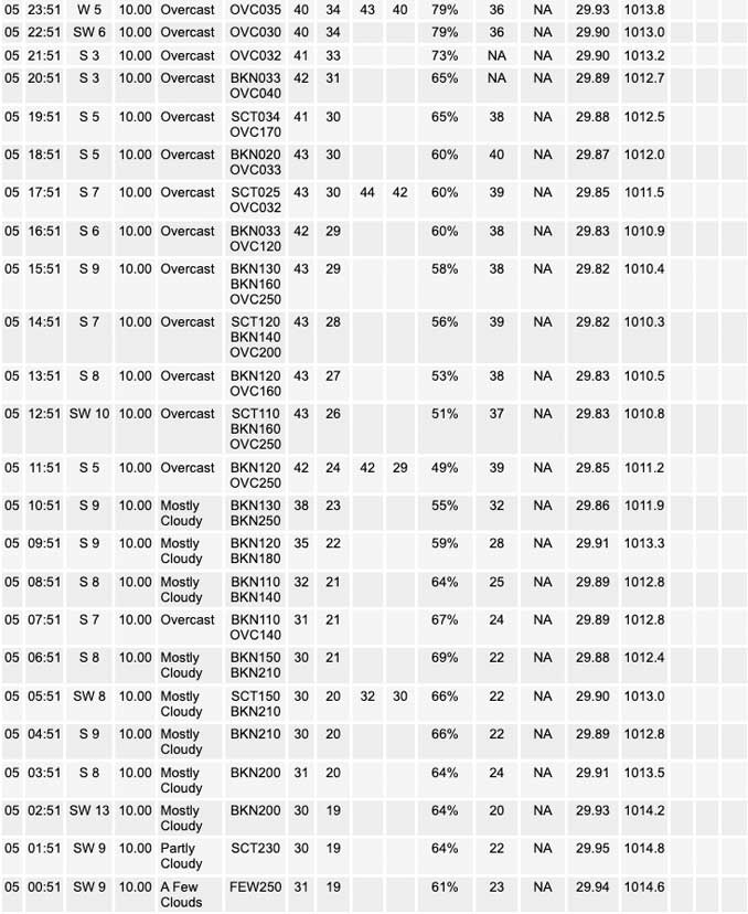
Early morning surface analysis shows 1000 mb low pressure north of the Great Lakes, with a cold front trailing southwest across the upper Mississippi Valley and into the High Plains. High pressure which had earlier been in place across the Ohio Valley has moved to the mid-Atlantic coast region. Aloft, flow was largely zonal across the central CONUS, with a sheared mid-level short wave evident over the central Rockies in water vapor imagery. This wave is progged to propagate east into our region through tonight, inducing a weak surface wave which will ripple northeast along the aforementioned cold front moving across the forecast area this evening. Regional radar mosaic already depicts developing returns across the Sioux Falls and IA/MN border regions is associated with strengthening low level frontogenesis north of the cold front, and banded precipitation is expected to continue to develop east- northeastward from far northern IA into southern WI through the day.
Southeast of the front, 00Z RAOBs from DVN and ILX indicate fairly dry profiles particularly in the low-mid levels. Low level moisture was evident upstream per low clouds across the Arklatex however, and south-southwest low level flow is progged to bring some of this into the local area later this afternoon and evening ahead of the approaching cold front. While this moisture is not very deep, forecast soundings do indicate saturation developing u Pto about 800 mb late this afternoon and evening across the southeast half of the forecast area. Increasing forcing for ascent associated with the approaching short wave and cold front should be enough to produce some patchy light rain or drizzle mainly southeast of about a Mendota-O`Hare-Highland Park line. High-res QPF is spotty, but several models indicate a few hundredths of an inch in these areas late this afternoon and evening. This light precip is expected to wane overnight as the cold front moves through, with temps holding above freezing until after it ends.
A similar scenario is expected Tuesday, as another low-amplitude short wave and jet streak are progged to move east from the Rockies/Plains across the region. Best chances look to be toward evening and later, but at least patchy light rain may develo Pduring the afternoon. Temps are again expected to be around 40/low 40s.
Ratzer/NWS Chicago
