
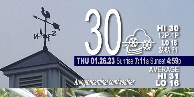
Thursday Hi 30, light snow ends 5p, mostly cloudy, winds NW to W to SW, 8 to 11 MPH, G14 to 18 to 15 MPH, 10a to 7p
NWS CHGO | NWS HRLY | /NWSchicago | 🌡
ARLINGTON HEIGHTS WEATHER
▴ forecast7 (Arl. Hts.) | RADAR | WIDE RADAR
⏪ Hrly Data Table | Hrly Future Graph ⏩
IMPORTANT NOTE ON NWS DATA
⏪ Hrly Data Table | Hrly Future Graph ⏩
======================
Thursday and Thursday Night …
Weather Hazards expected …
Limited Snow Risk.
DISCUSSION…
Light snowfall Thursday will result in a coating of an additional 0.8 to 1.0-inch snow accumulation and will lead to slippery travel conditions. Snowfall Thursday should end by about 5:00 p.m. Be prepared for low temperatures of 18°F from 2:00 a.m. to 6:00 a.m. Friday.
Two more days left of the normal daily low temperature bottomed out at 16°F. Normal daily high increases from 31°F to 32°F in five days. We’re gaining about 2 minutes of daylight every day in the progression toward vernal equinox, March 20, 2023.
======================
O’HARE FORECAST …
Forecast Beginning Thursday, Jan. 26, 2023
Thursday: Snow before 1pm, then snow showers likely, mainly after 4pm. High near 30. West wind 5 to 10 mph, with gusts as high as 20 mph. Chance of precipitation is 80%. Total daytime snow accumulation of less than one inch possible.
Thursday Night: Snow showers likely, mainly before 7pm. Cloudy, then gradually becoming partly cloudy, with a low around 18. West wind around 10 mph becoming south southwest after midnight. Winds could gust as high as 20 mph. Chance of precipitation is 60%. New snow accumulation of less than a half inch possible.
Friday: Snow showers likely, mainly between 7am and 1pm. Cloudy, with a high near 34. South wind around 15 mph, with gusts as high as 35 mph. Chance of precipitation is 70%. New snow accumulation of less than a half inch possible.
Friday Night: A chance of snow showers before 7pm, then a chance of sprinkles and flurries between 7pm and 1am. Mostly cloudy, with a low around 21. Breezy, with a west southwest wind 15 to 20 mph decreasing to 5 to 10 mph after midnight. Winds could gust as high as 30 mph. Chance of precipitation is 30%.
Saturday: Snow likely, mainly after 1pm. Cloudy, with a high near 30. West wind 5 to 10 mph becoming east northeast in the afternoon. Chance of precipitation is 70%.
Saturday Night: Snow likely, mainly before 1am. Cloudy, with a low around 22. Chance of precipitation is 70%.
Sunday: A 20 percent chance of snow before 7am. Mostly cloudy, with a high near 27.
Sunday Night: Mostly cloudy, with a low around 15.
Monday: Mostly cloudy, with a high near 21.
Monday Night: Mostly cloudy, with a low around 5.
Tuesday: Mostly sunny, with a high near 18.
Tuesday Night: A chance of snow. Mostly cloudy, with a low around 9.
Wednesday: A chance of snow. Mostly cloudy, with a high near 19.


CHICAGOWEATHERSTATION.COM

ChicagoWeatherStation.com I O’Hare Normal Temps/Precip I O’Hare Record Temps, Precip, Snow
LIVE RADAR | STORM TRACKS | UNISYS US IR SAT | UNISYS Midwest IR SAT | UNISYS More IR SAT
WunderMap® with Temperature/Wind Data || Google: Arlington Heights Area Temps | US TEMPS
Full Screen Motion Weather Radar (Wunderground.com)
Midwest Cloud Cover with Arlington Heights Weather Forecast
ChicagoWeatherStation.com I O’Hare Normal Temps/Precip I O’Hare Record Temps, Precip, Snow
SUNLIGHT DATA FOR SECURITY, TRAFFIC SAFETY, AND SPORTS
SunCalc.net data with solar azimuth and trajectory, times for dawn, sunrise, solar noon, sunset, dusk …
NIGHT SKY THIS MONTH …
Backyard stargazers get a monthly guide to the northern hemisphere’s skywatching events with “Tonight’s Sky.” Check the night sky objects for this month and past months in the playlist from the Space Telescope Science Institute YouTube channel (Musical track The Far River written by Jonn Serrie, from the album And the Stars Go With You courtesy of New World Music Ltd).
Get updates from The Cardinal ALL NEWS FEEDS on Facebook. Just ‘LIKE’ the ‘Arlington Cardinal Page (become a fan of our page). The updates cover all posts and sub-category posts from The Cardinal — Arlingtoncardinal.com. You can also limit feeds to specific categories. See all of The Cardinal Facebook fan pages at Arlingtoncardinal.com/about/facebook …
Help fund The Cardinal Arlingtoncardinal.com/sponsor
Area Forecast Discussion
National Weather Service Chicago/Romeoville, IL
553 AM CST Thu Jan 26 2023
.SHORT TERM… Issued at 250 AM CST Thu Jan 26 2023
Through Friday…
The main weather highlights through Friday are:
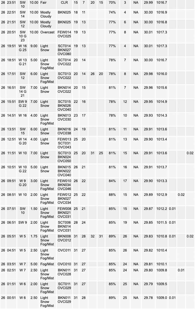
* Widespread, generally light, snow continuing this morning. Rates less than a quarter inch per hour.
* Temperatures falling into the mid and upper 20s yielding a threat for icy travel this morning.
* Continued snow showers this afternoon, with some reinvigoration possible across NE IL and NW IN ahead of a secondary vort max. Potential for a few more robust snow showers as a result.
* Another shot at snow showers on Friday. Some could be accompanied by strong gusts towards 40 mph and sharply reduced visibilities. Temperatures likely to warm above freezing in the afternoon.
Highly energetic cyclonic flow continues today, carrying along a series of embedded vort maxes across the Upper Midwest and Great Lakes regions. First disturbance is nearly overhead at this time and will continue to crank out pretty widespread light snow this morning. Modest cold advection will press mid and upper 20s temperatures into parts of the region (mainly SW 2/3rds). Earlier issued a Special Weather Statement to highlight the icy road threat as a result, mainly for secondary, elevated, and other untreated surfaces.
A secondary disturbance, this one a bit more robust and wound up than the current vort, is progressing towards the Minnesota Arrowhead at this time, and is slated to press across the region later this afternoon and evening. Model guidance ubiquitously cranks out additional snow showers in a narrow axis across NE Illinois where the overlap of attendant DCVA and best low-level moisture is maximized this afternoon and evening. RAP soundings even depict a little in the way of instability as lapse rates steepen up a bit. Have refined the inherited likely PoPs for this area. Ascent profiles, while not fully overlapping the prime snow growth zone, expand a bit and could easily see ascent build deeper aloft within convective elements as a result, suggesting a potential for a very localized swath of 1-2 inch amounts wherever this zone sets up, potentially straddling I-90.
Friday morning we`ll be turning our attention to another robust wave which looks to cross into the region through the morning hours. Somewhat intrigued by this system, as an intense low-level mass response is indicated across the guidance suite with 900 mb winds forecast to increase past 50 kts as a sharp warm advection wing passes overhead. While large scale forcing will be short- lived, it will be quite intense. Somewhat unstable look to soundings and cross sections aloft as well, so it seems like there`s a potential for a quick half inch to inch of snow along with wind gusts to maybe 40 mph if sufficient mixing can be realized. We`ll start the day on a cold note so any snow likely would have no problem sticking and causing some travel issues. Will start hitting the messaging for this a bit harder in this morning`s graphics.
Intense WAA will drive temperatures above freezing during the afternoon ahead of the main push of cold advection. Could see additional snow showers (rain south where temperatures may push in the mid/upper 30s) in the afternoon with more of a squall look to soundings as instability increases. Temperatures seem like they`d be warm enough by this time to limit impacts, but Friday as a whole seems to be a day for us to keep an eye on.
Carlaw/NWS Chicago
