
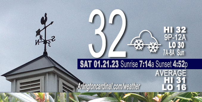
Saturday Hi 32 after 8p, snow 9p, increasing after 12a, cloudy, winds SW, 6 to 7 to 5 MPH
NWS CHGO | NWS HRLY | /NWSchicago | 🌡
ARLINGTON HEIGHTS WEATHER
▴ forecast7 (Arl. Hts.) | RADAR | WIDE RADAR
⏪ Hrly Data Table | Hrly Future Graph ⏩
IMPORTANT NOTE ON NWS DATA
⏪ Hrly Data Table | Hrly Future Graph ⏩
======================
Saturday and Saturday Night …
Weather Hazards expected …
Limited Snow Risk tonight.
DISCUSSION…
Light snow accumulations with accumulation up to two inches in some areas are forecast from Saturday night into Sunday with slippery travel possible. Snow accumulation in Arlington Heights and nearby communities likely to be 0.8 inches from 12:00 a.m. Sunday to about 10:00 a.m. to 12:00 p.m. Sunday. Snow flurries likely to begin about 9:00 p.m. Saturday in Arlington Heights. Snow accumulation forecast has trended downward in the 12 hours, therefore total accumulation in Arlington Heights may be less than 0.8 inches.
One week left of the normal daily low temperature bottomed out at 16°F. Daily high increases from 31°F to 32°F in ten days. Two minutes of daylight gained Friday and Saturday.
======================
O’HARE FORECAST …
Forecast Beginning Saturday, Jan. 21, 2023
Saturday: Cloudy, with a high near 31. Southwest wind around 5 mph, with gusts as high as 10 mph.
Saturday Night: Snow likely, mainly after 1am. Cloudy, with a low around 30. South southwest wind around 5 mph becoming calm after midnight. Chance of precipitation is 70%. New snow accumulation of less than a half inch possible.
Sunday: Snow likely, mainly before 10am. Cloudy, with a high near 34. Calm wind becoming north northwest around 5 mph in the afternoon. Chance of precipitation is 70%. New snow accumulation of less than a half inch possible.
Sunday Night: Cloudy, then gradually becoming partly cloudy, with a low around 24. Northwest wind 5 to 10 mph.
Monday: Sunny, with a high near 35. West southwest wind 5 to 15 mph, with gusts as high as 25 mph.
Monday Night: Partly cloudy, with a low around 28.
Tuesday: Mostly cloudy, with a high near 36.
Tuesday Night: A chance of snow after 1am. Cloudy, with a low around 30.
Wednesday: Snow likely, mainly between 7am and 1pm. Cloudy, with a high near 34.
Wednesday Night: A chance of snow before 7pm. Cloudy, with a low around 21.
Thursday: Cloudy, with a high near 29.
Thursday Night: Mostly cloudy, with a low around 18.
Friday: Mostly cloudy, with a high near 28.


CHICAGOWEATHERSTATION.COM

ChicagoWeatherStation.com I O’Hare Normal Temps/Precip I O’Hare Record Temps, Precip, Snow
LIVE RADAR | STORM TRACKS | UNISYS US IR SAT | UNISYS Midwest IR SAT | UNISYS More IR SAT
WunderMap® with Temperature/Wind Data || Google: Arlington Heights Area Temps | US TEMPS
Full Screen Motion Weather Radar (Wunderground.com)
Midwest Cloud Cover with Arlington Heights Weather Forecast
ChicagoWeatherStation.com I O’Hare Normal Temps/Precip I O’Hare Record Temps, Precip, Snow
SUNLIGHT DATA FOR SECURITY, TRAFFIC SAFETY, AND SPORTS
SunCalc.net data with solar azimuth and trajectory, times for dawn, sunrise, solar noon, sunset, dusk …
NIGHT SKY THIS MONTH …
Backyard stargazers get a monthly guide to the northern hemisphere’s skywatching events with “Tonight’s Sky.” Check the night sky objects for this month and past months in the playlist from the Space Telescope Science Institute YouTube channel (Musical track The Far River written by Jonn Serrie, from the album And the Stars Go With You courtesy of New World Music Ltd).
Get updates from The Cardinal ALL NEWS FEEDS on Facebook. Just ‘LIKE’ the ‘Arlington Cardinal Page (become a fan of our page). The updates cover all posts and sub-category posts from The Cardinal — Arlingtoncardinal.com. You can also limit feeds to specific categories. See all of The Cardinal Facebook fan pages at Arlingtoncardinal.com/about/facebook …
Help fund The Cardinal Arlingtoncardinal.com/sponsor
Area Forecast Discussion
National Weather Service Chicago/Romeoville, IL
541 AM CST Sat Jan 21 2023
.SHORT TERM… Issued at 259 AM CST Sat Jan 21 2023
Through Sunday…
The focus in the short term remains the widespread light snow anticipated tonight into Sunday morning. The system in question is currently spinning over the Oklahoma panhandle early this morning before jetting eastward across the northern ArkLaTex region and through the lower Midwest tonight through Sunday. As it does, the associated upper trough is expected to deamplify quite a bit. Nonetheless, the left exit region of a persistent ~100kt midlevel jet max on the trough`s leeward side will still provide a great deal of synoptic-scale forcing over parts of the Midwest. The only problem is it looks as though the better forcing will be missing the CWA just to the south.
While still a modest signal, there has been an uptick among guidance in ephemeral pockets of mid level frontogenesis and negative EPV developing over parts of the CWA. Likely setting u Pwithin or just outside of a saturated DGZ, the f-gen pockets will likely coincide with short bursts of “heavier” snow. However, where exactly these localized f-gen bands want to pop up remains a big question making it particularly difficult to determine where the highest snow totals will be found. There is a chance that the snowfall distribution could be rather sporadic. There`s a great deal of disagreement among high-res models on where the highest totals will end up. A few models suggest that higher rates will develop across the southern CWA where some meager mid level instability can supposedly be found.
Looking at the big picture, we`re not expecting a whole lot of spread in snow totals anyway. Widespread coatings to around an inch and a half is what we`re currently looking at. Up to two inches may be possible over areas that receive heavier bursts/bands of snow. The greatest potential for areas of moderate snow is during a midnight-6AM timeframe, which is also when we should see the greatest coverage in snowfall. The snow is then expected to taper off from west to east through the rest of the morning, possibly stretching into the early afternoon.
A marginal lake effect setup could bring some additional snow showers to parts of far northwest Indiana through the afternoon and possibly beyond. Low level winds will be turning roughly northerly behind the low level trough axis. Lake surface temperatures across the southern portion of the lake in the upper 30s/lower 40s result in a ~10-12C sfc-850 delta-T and a small, though notable, amount of lake-induced instability. This minimally impressive environment should keep snow rates and coverage rather tame should lake- effect snow develop. More on the lake-effect setup can be found in the long term discussion below.
Doom/NWS Chicago
