
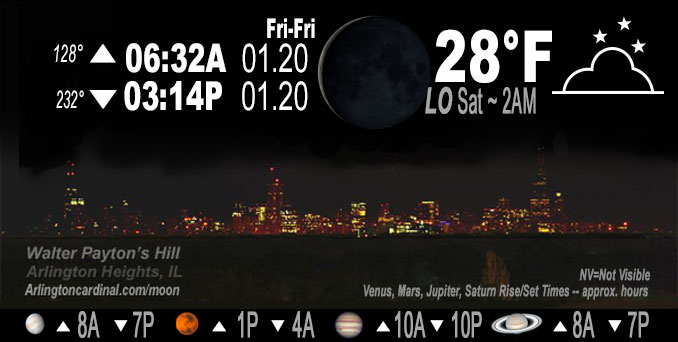
🌘 🌑 🌗 🌕 Waning Crescent Moon, sky cover overnight Fri. to Sat. 100% to 80%, winds NW to W to WSW, 9 to 6 MPH, Low 28, 2a to 8a
NWS CHGO | NWS HRLY | /NWSchicago | 🌡
ARLINGTON HEIGHTS WEATHER
▴ forecast7 (Arl. Hts.) | RADAR | WIDE RADAR
IMPORTANT NOTE ON NWS DATA
======================
NIGHT FORECASTS …
NOTE 1: Forecast and information text below may refer to a previous night on Arlingtoncardinal.com, and might not be updated until late afternoon, evening, or overnight. However, Night Sky archives on CARDINAL NEWS Magazine include text forecasts that correspond to the lunar phase graphic above.
NOTE 2: Keep in mind lunar rise and set times don’t always correspond with night weather and early morning lows because on some days during the month the moon is visible in the sky predominantly during the daytime hours.
Overnight Friday/Saturday …
No Weather Hazards expected …
Low 28° F, some clouds clearing after midnight Friday/Saturday.
DISCUSSION…
Cloud cover should continue to suppress the diurnal temp range — NWS leaning on the warmer side of guidance for lows
Friday night/Saturday morning, and a nod toward the lower end of guidance for highs Saturday.
Hello mobile users! If you encounter mobile “unfriendly” weather page, turn your phone sideways for a better view.
======================
O’HARE FORECAST …
Forecast Beginning Friday Night, Jan. 20, 2023 …
Friday Night: Cloudy, with a low around 27. West northwest wind 5 to 10 mph.
Saturday: Mostly cloudy, with a high near 34. Southwest wind 5 to 10 mph.
Saturday Night: Snow likely, mainly after 1am. Cloudy, with a low around 30. Southwest wind around 5 mph becoming calm after midnight. Chance of precipitation is 70%. New snow accumulation of less than one inch possible.
Sunday: Snow likely, mainly before 7am. Cloudy, with a high near 35. Calm wind becoming northwest around 5 mph in the afternoon. Chance of precipitation is 70%. New snow accumulation of less than a half inch possible.
Sunday Night: Mostly cloudy, with a low around 25. North northwest wind 5 to 10 mph.
Monday: Sunny, with a high near 34.
Monday Night: Mostly cloudy, with a low around 29.
Tuesday: Mostly cloudy, with a high near 38.
Tuesday Night: A chance of snow after 1am. Cloudy, with a low around 30.
Wednesday: A chance of snow. Cloudy, with a high near 32.
Wednesday Night: A chance of snow. Cloudy, with a low around 20.
Thursday: Cloudy, with a high near 28.
Thursday Night: Cloudy, with a low around 19.
Friday: Cloudy, with a high near 25.
O’Hare forecast archive and hourly weather observations archive are available HERE on the CARDINAL NEWS Magazine.
Arlingtoncardinal.com/moonphases
Arlingtoncardinal.com/nightsky
NIGHT SKY THIS MONTH …
Check the night sky objects for this month and past months in the playlist from the Space Telescope Science Institute YouTube channel Backyard stargazers get a monthly guide to the northern hemisphere’s skywatching events with “Tonight’s Sky” (Musical track The Far River written by Jonn Serrie, from the album And the Stars Go With You courtesy of New World Music Ltd. Musical track The Far River written by Jonn Serrie, from the album And the Stars Go With You courtesy of New World Music Ltd).
Telephoto lens, ISO 100, f/11, Shutter Speed 1/100 to 1/125 for the Moon.
Get updates from The Cardinal ALL NEWS FEEDS on Facebook. Just ‘LIKE’ the ‘Arlington Cardinal Page (become a fan of our page). The updates cover all posts and sub-category posts from The Cardinal — Arlingtoncardinal.com. You can also limit feeds to specific categories. See all of The Cardinal Facebook fan pages at Arlingtoncardinal.com/about/facebook …
Help fund The Cardinal Arlingtoncardinal.com/sponsor
Telephoto lens, ISO 1600, f/11, Shutter Speed 2.5″ for the skyline. The skyline exposure was toned down, and brightness and contrast was adjusted in Photoshop.
Area Forecast Discussion
National Weather Service Chicago/Romeoville, IL
528 PM CST Fri Jan 20 2023
.SHORT TERM… Issued at 245 PM CST Fri Jan 20 2023
Through Sunday…
Primary short term forecast focus:
* Light snow with minor accumulations expected Saturday night into early Sunday morning
Stratus blankets majority of the region this afternoon with GOES-16 Day Snow-Fog RGB showing some thinning of the stratus with even a couple of holes opening up over portions of Iowa. While there could be a few breaks in the overcast skies overnight and particularly Saturday, generally thinking it should remain fairly cloudy. Cloud cover should continue to suppress the diurnal tem Prange and have leaned on the warmer side of guidance for lows tonight and a nod toward the lower end of guidance for highs Saturday. Didn`t go as cold as it would likely be if it stays overcast, since there could be some meaningful breaks tomorrow afternoon. If stratus holds strong, then highs may need to be nudged down a bit Saturday.
Our Saturday night/Sunday A.M. system continues to look very impressive on water vapor imagery this afternoon over the Four Corners region. Short range guidance remains in good agreement on opening this closed mid-upper level low up and dampening it out as it moves into an increasingly confluent flow over the central U.S. Saturday into Saturday night. While all indications are that the system will be weakening as it moves across the region, there is still strong agreement in guidance in a widespread light snow with some minor accumulations.
Even with the wave opening up/dampening out, combination of divergence in the left exit region of 130kt 300mb jet and DCVA ahead of the advancing trough should result in a swath of light snow overspreading the area Saturday night, then ending Sunday morning as the trough axis moves east of the CWA. The NAM in particular does show some transient low-mid level f-gen, though that is primarily early on in the event before column is fully saturated.
Cross sections from the NAM and GFS both show lingering low level moisture (current stratus deck) Saturday night with this system while top down saturation occurs above this shallow low level moist layer. The strongest forcing with the transient f-gen features in the NAM are toward the onset of the event with most of that forcing going toward erasing the intervening dry layer.
Already pretty light QPF in the models has trended another tick downward this cycle. Forecast thermal/moisture profiles and omega would suggest primarily needles and plates for snow type, which wouldn`t favor high snow liquid ratios. Still thinking snow:liquid ratios should end up in the 10-15:1 range, which is pretty close to climo. Given the slightly lower QPF, a coating to an inch or so or snow appears likely. Below freezing temps should allow for travel impacts despite the rather meager snow amounts.
– Izzi/NWS Chicago
