
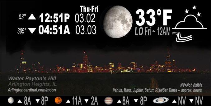
🌔 🌕 🌗 🌑 Waxing Gibbous Moon, sky cover overnight Thu. to Fri. 83% to 93%, winds NE to ENE to E, 9 to 14 MPH, G13 to 22 MPH, 5p into Fri., Low 33, 12a to 7a
NWS CHGO | NWS HRLY | /NWSchicago | 🌡
ARLINGTON HEIGHTS WEATHER
▴ forecast7 (Arl. Hts.) | RADAR | WIDE RADAR
IMPORTANT NOTE ON NWS DATA
======================
NIGHT FORECASTS …
NOTE: Keep in mind lunar rise and set times don’t always correspond with night weather and early morning lows because on some days during the month the moon is visible in the sky predominantly during the daytime hours.
Overnight Thursday/Friday …
No Weather Hazards expected
No hazards Thursday night, and Friday’s storm system forecast was highly unpredictable. A Winter Storm Watch for Friday was issued Thursday morning and expired. The Winter Weather Advisory for Friday replaced the Winter Storm watch at 8:38 p.m. Thursday.
DISCUSSION…
An anticipated storm bringing deep snow diverted south and the Winter Storm Watch is expired; and a Winter Weather Advisory is activated. By Friday after sunrise, the snowfall accumulation forecast for Arlington Heights and nearby communities was less than 0.5 inch.
Jupiter and Venus in conjunction visible after sunset in west sky, except cloud cover will make it difficult or impossible. Both planets set about 8:15 p.m. Venus sets at 8:17 p.m. and Jupiter sets at 8:12 p.m.
Hello mobile users! If you encounter a mobile “unfriendly” weather page, turn your phone sideways for a better view.
======================
O’HARE FORECAST …
Forecast Beginning Thursday Night, Mar. 02, 2023 …
(issued 5:51 p.m.)
Thursday Night: Mostly cloudy, with a low around 33. East northeast wind around 10 mph, with gusts as high as 15 mph.
Friday: Snow, mainly after noon. High near 35. Breezy, with an east northeast wind 10 to 15 mph increasing to 20 to 25 mph in the afternoon. Winds could gust as high as 35 mph. Chance of precipitation is 80%. New snow accumulation of 1 to 3 inches possible.
Friday Night: A 50 percent chance of snow before midnight. Mostly cloudy, with a low around 29. Blustery, with a north wind 15 to 20 mph becoming west northwest 10 to 15 mph after midnight. Winds could gust as high as 35 mph.
Saturday: Sunny through mid morning, then becoming mostly cloudy, with a high near 44. West southwest wind 5 to 10 mph.
Saturday Night: Mostly cloudy, with a low around 29. West southwest wind 5 to 10 mph becoming north northwest after midnight.
Sunday: Partly sunny, with a high near 45.
Sunday Night: A 40 percent chance of rain, mainly after midnight. Mostly cloudy, with a low around 39.
Monday: A chance of rain. Mostly cloudy, with a high near 54.
Monday Night: Mostly cloudy, with a low around 34.
Tuesday: Partly sunny, with a high near 43.
Tuesday Night: Mostly cloudy, with a low around 31.
Wednesday: Partly sunny, with a high near 40.
Wednesday Night: Mostly cloudy, with a low around 29.
Thursday: Partly sunny, with a high near 38
O’Hare forecast archive and hourly weather observations archive are available HERE on the CARDINAL NEWS Magazine.
Arlingtoncardinal.com/moonphases
Arlingtoncardinal.com/nightsky
NIGHT SKY THIS MONTH …
Check the night sky objects for this month and past months in the playlist from the Space Telescope Science Institute YouTube channel Backyard stargazers get a monthly guide to the northern hemisphere’s skywatching events with “Tonight’s Sky” (Musical track The Far River written by Jonn Serrie, from the album And the Stars Go With You courtesy of New World Music Ltd. Musical track The Far River written by Jonn Serrie, from the album And the Stars Go With You courtesy of New World Music Ltd).
Telephoto lens, ISO 100, f/11, Shutter Speed 1/100 to 1/125 for the Moon.
Get updates from The Cardinal ALL NEWS FEEDS on Facebook. Just ‘LIKE’ the ‘Arlington Cardinal Page (become a fan of our page). The updates cover all posts and sub-category posts from The Cardinal — Arlingtoncardinal.com. You can also limit feeds to specific categories. See all of The Cardinal Facebook fan pages at Arlingtoncardinal.com/about/facebook …
Help fund The Cardinal Arlingtoncardinal.com/sponsor
Telephoto lens, ISO 1600, f/11, Shutter Speed 2.5″ for the skyline. The skyline exposure was toned down, and brightness and contrast was adjusted in Photoshop.
Area Forecast Discussion
National Weather Service Chicago/Romeoville, IL
346 AM CST Fri Mar 3 2023
.SHORT TERM… Issued at 345 AM CST Fri Mar 3 2023
Through Saturday…
Key Messages:
* Due to the combination of high snowfall rates and wind gusts over 45 mph, concerns are increasing that dangerous to potentially crippling travel conditions develop this afternoon for areas east of I-57 (Winter Storm Warning)
* Sharp northwest cut-off of snowfall amounts and winter impacts with the southern Chicago metro right along the gradient in snowfall totals
* Confidence in the west and northwest extent of snowfall remains low and amounts could still overperform in the Winter Weather Advisory areas
* Mesoscale feature could bring period of gusts to near 60 mph during the afternoon and accordingly exacerbate blizzard conditions and power outages (low confidence)
* Combined liquid from snow and rain could exceed 2 inches and result in ponding in poor drainage areas and river rises generally southeast of a Pontiac, IL to Gary, IN line
All eyes are on the low pressure system lifting north northeast through Arkansas at this hour. This is expected to quickly deepen over the next several hours. In fact, if modeled surface pressure verify it could threaten all-time record low pressure for western Indiana!
The necessary ingredients needed for high snowfall rates are in place over portions of the area, with frontogenesis and very strong lift in the dendritic growth layer. While ground temperatures remain warm given the anomalous warmth we have had the past couple days, it will not take long for intense snowfall rates (over 1 inch per hour) to overcome this and create very hazardous travel conditions.
The precipitation type at onset is likely to be rain across the entire area through the morning hours. Don`t let this fool you, winter impacts are not anticipated to develop until this afternoon when wet-bulb cooling within the heavy rain shield becomes sufficient to allow snow to reach the surface. Once this occurs the necessary ingredients needed for extreme snowfall rates are in place over the portions of the area, with strong mid-level frontogenesis, very strong lift, and elevated instability.
The areal coverage of very impactful winter conditions hinge on sufficient wet-bulb cooling and there remains uncertainty with when and how widespread sufficient wet-bulb cooling occurs. The difference between crippling snowfall and just rain or rain/snow mix with limited impacts is very tenuous. Even a 1 degree difference in temperature can make the difference between 2″+/hour snowfall and just heavy rain. Thus there is still a large range in potential snowfall outcomes, particularly in the Winter Weather Advisory area where higher amounts cannot be ruled out, so later forecasts should be closely monitor.
With a deep surface low comes strong surface winds due to the tightening surface pressure gradient. Confidence is high in seeing frequent wind gusts in excess of 45 mph along and southeast of I-57. With these winds in mind, blizzard-like conditions cannot be ruled out but confidence in a longer duration and greater coverage of these conditions preclude an upgrade with this forecast package. Will note that hi-res guidance, and in particular the HRRR, is trying to resolve a mesoscale feature (possible gravity wave?) with a period of winds gusting to near 60mph this afternoon. Confidence in winds of this magnitude actually occurring is low though it will be something to monitor very closely as it would ramp up impacts a couple notches, including exacerbating blizzard-like conditions.
In the wake of this system temperatures still manage to rebound on Saturday with low-amplitude ridging moving overhead with a weak shortwave pushing through right on its heels. This should allow temperatures to warm into the lower 40s (upper 30s where highest snowfall amounts end up). There is a slight chance (20%) that a few light showers move through in the afternoon.
Petr/NWS Chicago
