
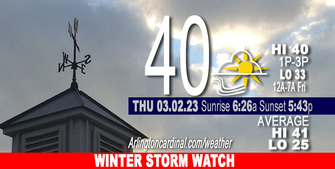
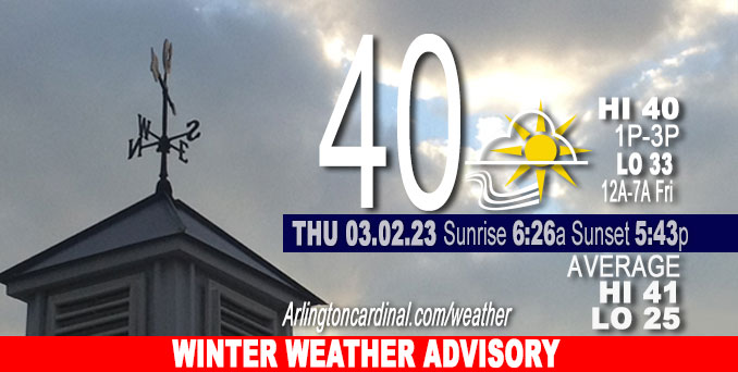
Thursday Hi 40, mostly cloudy, winds NNE to NE to ENE, 8 to 6 to 10 MPH, G13 to 15, 5p to 10p
NWS CHGO | NWS HRLY | /NWSchicago | 🌡
ARLINGTON HEIGHTS WEATHER
▴ forecast7 (Arl. Hts.) | RADAR | WIDE RADAR
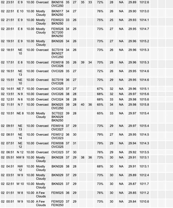
⏪ Hrly Data Table | Hrly Future Graph ⏩
IMPORTANT NOTE ON NWS DATA
⏪ Hrly Data Table | Hrly Future Graph ⏩
======================
Thursday and Thursday Evening …
Weather Hazards expected …
Winter Storm Watch URGENT – WINTER WEATHER MESSAGE National Weather Service Chicago IL 934 AM CST Thu Mar 2 2023
Kane-DuPage-La Salle-Kendall-Grundy-Kankakee-Livingston-Iroquois- Ford-Northern Cook-Central Cook-Southern Cook-Northern Will- Southern Will-Eastern Will-Lake IN-Porter-Newton-Jasper- Including the cities of Aurora, Elgin, Naperville, Wheaton, Downers Grove, Lombard, Carol Stream, Ottawa, Streator, La Salle, Mendota, Marseilles, Oswego, Yorkville, Plano, Morris, Coal City, Minooka, Kankakee, Bourbonnais, Bradley, Pontiac, Dwight, Fairbury, Watseka, Gilman, Paxton, Gibson City, Evanston, Des Plaines, Schaumburg, Palatine, Northbrook, Chicago, Cicero, Oak Lawn, Oak Park, La Grange, Calumet City, Oak Forest, Lemont, Orland Park, Park Forest, Joliet, Bolingbrook, Plainfield, Mokena, Channahon, Manhattan, Wilmington, Crete, Peotone, Beecher, Gary, Hammond, Merrillville, Portage, Valparaiso, Chesterton, Roselawn, Kentland, Morocco, Rensselaer, and DeMotte 934 AM CST Thu Mar 2 2023
…WINTER STORM WATCH REMAINS IN EFFECT FROM FRIDAY MORNING THROUGH FRIDAY EVENING…
* WHAT…Rain changing to heavy wet snow possible. Total snow accumulations of up to 5 to 8 inches possible. Winds could gust as high as 45 mph.
* WHERE…Portions of central, east central, north central and northeast Illinois and northwest Indiana.
* WHEN…From Friday morning through Friday evening.
* IMPACTS…Travel could be very difficult. The hazardous conditions are most likely to impact the afternoon and evening commutes.
* ADDITIONAL DETAILS…Snowfall rates of 1 to 2 inches per hour are possible Friday afternoon with a narrow zone which will allow snow to accumulate on most road surfaces. Additionally, the heavy, wet nature of snow combined with the strong winds will lead to a potential for scattered power outages where the heaviest snow falls.
URGENT – WINTER WEATHER MESSAGE
National Weather Service Chicago IL
838 PM CST Thu Mar 2 2023
DuPage-Kendall-Grundy-Livingston-Ford-Central Cook-Southern Cook- Northern Will-Southern Will- Including the cities of Naperville, Wheaton, Downers Grove, Lombard, Carol Stream, Oswego, Yorkville, Plano, Morris, Coal City, Minooka, Pontiac, Dwight, Fairbury, Paxton, Gibson City, Chicago, Cicero, Oak Lawn, Oak Park, La Grange, Calumet City, Oak Forest, Lemont, Orland Park, Park Forest, Joliet, Bolingbrook, Plainfield, Mokena, Channahon, Manhattan, and Wilmington 838 PM CST Thu Mar 2 2023
…WINTER WEATHER ADVISORY IN EFFECT FROM NOON TO 10 PM CST FRIDAY…
* WHAT…Wet snow during the Friday afternoon and evening commute expected. Total snow accumulations of 1 to 4 inches expected, with locally higher amounts possible. In addition, northeasterly wind will gust up to 40 mph.
* WHERE…Portions of central, east central and northeast Illinois.
* WHEN…From noon to 10 PM CST Friday.
* IMPACTS…Plan on slippery road conditions including during the Friday afternoon and evening commute.
* ADDITIONAL DETAILS…The snow will be wet and slushy. As a result, even minimal snow accumulations will make road conditions slippery.
PRECAUTIONARY/PREPAREDNESS ACTIONS…
Slow down and use caution while traveling.
The latest road conditions for Illinois can be obtained on the internet at www.gettingaroundillinois.com.
DISCUSSION…
A Winter Storm Watch was issued Thursday morning and expired. The Winter Weather Advisory replaced the Winter Storm watch at 8:38 p.m. Thursday.
======================
O’HARE FORECAST …
Forecast Beginning Thursday, Mar. 02, 2023
Thursday: Mostly cloudy, with a high near 40. North northeast wind 5 to 10 mph.
Thursday Night: Mostly cloudy, with a low around 32. Northeast wind 10 to 15 mph, with gusts as high as 20 mph.
Friday: A chance of rain and snow before noon, then snow. The snow could be heavy at times. High near 34. Breezy, with an east northeast wind 15 to 25 mph, with gusts as high as 40 mph. Chance of precipitation is 80%. New snow accumulation of 3 to 7 inches possible.
Friday Night: A 40 percent chance of snow before midnight. Mostly cloudy, with a low around 28. Blustery, with a north wind 15 to 20 mph becoming west northwest 10 to 15 mph after midnight. Winds could gust as high as 35 mph.
Saturday: Partly sunny, with a high near 43. West southwest wind 5 to 10 mph.
Saturday Night: Mostly cloudy, with a low around 28.
Sunday: Partly sunny, with a high near 45.
Sunday Night: A chance of rain. Mostly cloudy, with a low around 38.
Monday: A chance of rain after noon. Mostly cloudy, with a high near 53.
Monday Night: Mostly cloudy, with a low around 35.
Tuesday: Partly sunny, with a high near 44.
Tuesday Night: Mostly cloudy, with a low around 31.
Wednesday: Partly sunny, with a high near 39.


CHICAGOWEATHERSTATION.COM

ChicagoWeatherStation.com I O’Hare Normal Temps/Precip I O’Hare Record Temps, Precip, Snow
LIVE RADAR | STORM TRACKS | UNISYS US IR SAT | UNISYS Midwest IR SAT | UNISYS More IR SAT
WunderMap® with Temperature/Wind Data || Google: Arlington Heights Area Temps | US TEMPS
Full Screen Motion Weather Radar (Wunderground.com)
Midwest Cloud Cover with Arlington Heights Weather Forecast
ChicagoWeatherStation.com I O’Hare Normal Temps/Precip I O’Hare Record Temps, Precip, Snow
SUNLIGHT DATA FOR SECURITY, TRAFFIC SAFETY, AND SPORTS
SunCalc.net data with solar azimuth and trajectory, times for dawn, sunrise, solar noon, sunset, dusk …
NIGHT SKY THIS MONTH …
Backyard stargazers get a monthly guide to the northern hemisphere’s skywatching events with “Tonight’s Sky.” Check the night sky objects for this month and past months in the playlist from the Space Telescope Science Institute YouTube channel (Musical track The Far River written by Jonn Serrie, from the album And the Stars Go With You courtesy of New World Music Ltd).
Get updates from The Cardinal ALL NEWS FEEDS on Facebook. Just ‘LIKE’ the ‘Arlington Cardinal Page (become a fan of our page). The updates cover all posts and sub-category posts from The Cardinal — Arlingtoncardinal.com. You can also limit feeds to specific categories. See all of The Cardinal Facebook fan pages at Arlingtoncardinal.com/about/facebook …
Help fund The Cardinal Arlingtoncardinal.com/sponsor
Area Forecast Discussion
National Weather Service Chicago/Romeoville, IL
624 AM CST Thu Mar 2 2023
.SHORT TERM… Issued at 309 AM CST Thu Mar 2 2023
Through Friday Night…
Some low cloud coverage is moving into the region, behind the weak frontal passage that occurred overnight. This cloud coverage will continue to drop southward into the region today, leading to overcast skies and holding temperatures at bay in the upper 30s along the lake, while inland peaks this afternoon in the low to mid 40s.
Main focus has been on the pending large-scale winter weather system that is forecast to track through the region Friday into Friday evening. First things first, a Winter Storm Watch has been issued across a widespread portion of the local CWA, to include the Chicago metro. This system is beginning to track from the desert sw through the southern US, with a quick cruise through Texas to load up on moisture from the Gulf. As this lifts nne through the Mississippi River Valley, expecting temperatures to hold steady in the low to mid 30s tonight. Temperatures Friday will likely initially start out above freezing before falling due to evaporative cooling as precipitation overspreads the region. Expecting start of precip to begin as rainfall in central IL, while the Low slides into the mid-Mississippi River Valley before changing to a mixed precipitation or all snowfall across the area. A majority of the area will see a mixed rain/snow event through the morning, before what appears to be a full changeover to snow as temperatures begin cooling into the afternoon overnight. Heading into the overnight, snowfall overspreads the region adding additional accumulations. This system then scoots out toward the northeast US late Friday night into Saturday.
Big focus for Friday`s winter storm potential will be the nature of snowfall. This event is shaping up to be a heavy, wet natured snowfall…with SLR values possibly in the 5-8 range (locally higher possible). If this comes to fruition, major compaction of snowfall will occur on sfcs leading to the potential for significant impacts around the region. As for overall amounts, while the numbers are initial and will change, it appears upwards of 5 to 8 inches of snowfall will be possible along the axis of heaviest snowfall, outlined by the Winter Storm Watch. Another thing we are monitoring, is windy conditions as the Low core tracks near the Ohio River Valley. Windy conditions mixed with heavy, wet snowfall could lead to rapid accumulations on trees and power lines, which could topple as the weight of snow takes a toll…potentially leading to power outages and other impacts. Overall blowing snow potential appears lower due to the very wet nature of snowflakes, although some localized blowing in open areas is possible.
A note about the uncertainty aspect of this forecast: A good deal of uncertainty still remains with this system, and unusually large for this time range. Although most model agreement has placed the Low track near the Ohio River Valley, few models still project a potential northward shift…which could lead to more rain over our south and shifting the axis of heaviest snow north and west. There are only a select one or two that have a south fetch of the track, which would lead to either more snowfall across the area or potential for a miss. These models have been analyzed (mainly NAMs), however at this time they are the outliers to the consensus of the majority. As for the Winter Storm Watch, the overall uncertainty did play a role in the determination of placement this morning. Some could look at the potential for the entire CWA having been placed in the WSW given the incredible spread in guidance as this short timeframe, however with the current trends and information available it was decided to leave some out…not to say a shift in the product will not occur, but for starters this was the best fit placement based on the multi- model guidance available to us right now.
Baker/NWS Chicago
