
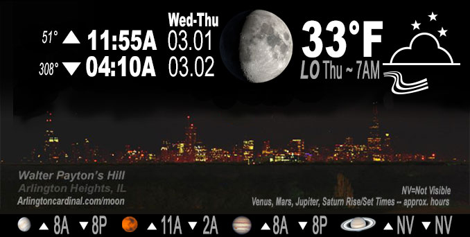
🌔 🌕 🌗 🌑 Waxing Gibbous Moon, sky cover overnight Wed. to Thu. 35% to 27% to 91%, winds WSW to NW to NNW, 9 to 7 to 13 to 9 to 10 MPH, G12 to 24 to 17 MPH, 8p into Thu., Low 33, 5a to 8a
NWS CHGO | NWS HRLY | /NWSchicago | 🌡
ARLINGTON HEIGHTS WEATHER
▴ forecast7 (Arl. Hts.) | RADAR | WIDE RADAR
IMPORTANT NOTE ON NWS DATA
======================
NIGHT FORECASTS …
NOTE: Keep in mind lunar rise and set times don’t always correspond with night weather and early morning lows because on some days during the month the moon is visible in the sky predominantly during the daytime hours.
Overnight Tuesday/Wednesday …
No Weather Hazards expected
Even with increasing cloud cover overnight, temperatures will fall overnight to 33°F at 7:00 a.m. and will not recover to mild temperatures of the past couple of days. Jupiter and Venus in conjunction visible after sunset in west sky. Both planets set about 8:15 p.m. Venus sets at 8:15 p.m. and Jupiter sets at 8:14 p.m.
DISCUSSION…
While cloud cover will increase with this front, forecast soundings continue to show a stout dry layer aloft which is expected to keep any precipitation chances to a minimum. However, the front will usher in colder air on breezy northwest winds which will lower temperatures into the low to mid-30s overnight. Temperatures should rebound somewhat Thursday afternoon as warm advection begins to move across the area ahead of our next storm system with highs expected to top out in the low to mid-40s. NOTE: Forecast Thursday morning did not expect Thursday to rebound to mid-40s, instead the forecast indicates a high of 40°F. Also, previous two daily highs have outperformed the forecast highs (51/47 and 57/56).
Hello mobile users! If you encounter a mobile “unfriendly” weather page, turn your phone sideways for a better view.
======================
O’HARE FORECAST …
Forecast Beginning Wednesday Night, Mar. 01, 2023 …
Wednesday Night: Mostly cloudy, with a low around 33. West northwest wind 5 to 15 mph, with gusts as high as 25 mph.
Thursday: Cloudy, with a high near 38. North wind around 10 mph, with gusts as high as 15 mph.
Thursday Night: A chance of rain and snow after 1am. Mostly cloudy, with a low around 33. East wind 10 to 15 mph, with gusts as high as 25 mph. Chance of precipitation is 40%.
Friday: Rain and snow, mainly after 7am. High near 37. Breezy, with an east northeast wind 15 to 25 mph, with gusts as high as 40 mph. Chance of precipitation is 90%.
Friday Night: Rain and snow before 10pm, then a chance of snow between 10pm and 1am. Low around 29. Blustery. Chance of precipitation is 90%.
Saturday: Partly sunny, with a high near 40.
Saturday Night: Mostly cloudy, with a low around 28.
Sunday: Mostly sunny, with a high near 44.
Sunday Night: Mostly cloudy, with a low around 33.
Monday: Mostly cloudy, with a high near 47.
Monday Night: Mostly cloudy, with a low around 36.
Tuesday: Partly sunny, with a high near 43.
O’Hare forecast archive and hourly weather observations archive are available HERE on the CARDINAL NEWS Magazine.
Arlingtoncardinal.com/moonphases
Arlingtoncardinal.com/nightsky
NIGHT SKY THIS MONTH …
Check the night sky objects for this month and past months in the playlist from the Space Telescope Science Institute YouTube channel Backyard stargazers get a monthly guide to the northern hemisphere’s skywatching events with “Tonight’s Sky” (Musical track The Far River written by Jonn Serrie, from the album And the Stars Go With You courtesy of New World Music Ltd. Musical track The Far River written by Jonn Serrie, from the album And the Stars Go With You courtesy of New World Music Ltd).
Telephoto lens, ISO 100, f/11, Shutter Speed 1/100 to 1/125 for the Moon.
Get updates from The Cardinal ALL NEWS FEEDS on Facebook. Just ‘LIKE’ the ‘Arlington Cardinal Page (become a fan of our page). The updates cover all posts and sub-category posts from The Cardinal — Arlingtoncardinal.com. You can also limit feeds to specific categories. See all of The Cardinal Facebook fan pages at Arlingtoncardinal.com/about/facebook …
Help fund The Cardinal Arlingtoncardinal.com/sponsor
Telephoto lens, ISO 1600, f/11, Shutter Speed 2.5″ for the skyline. The skyline exposure was toned down, and brightness and contrast was adjusted in Photoshop.
Area Forecast Discussion
National Weather Service Chicago/Romeoville, IL
1242 AM CST Thu Mar 2 2023
.SHORT TERM… Issued at 345 PM CST Wed Mar 1 2023
Through Friday night…
Forecast concerns for the short term period…
*Strong storm system looks to bring potentially heavy precipitation to the area on Friday
*Continued uncertainty on where the heaviest axis of precipitation would set up especially in regards to snowfall
*Gusty winds look to accompany the precipitation with gusts in excess of 35 to 40 mph possible
The beginning of the period is expected to be rather quiet as high pressure begins to build into the area in the wake of a shortwave trough that is currently traversing the northern Plains and upper Midwest. As this shortwave moves through the region a weak cold front will swing though northeastern Illinois and northwest Indiana this evening. While cloud cover will increase with this front, forecast soundings continue to show a stout dry layer aloft which is expected to keep any precipitation chances to a minimum. However, the front will usher in colder air on breezy northwest winds which will lower temperatures into the low to mid-30s overnight. Temperatures should rebound somewhat Thursday afternoon as warm advection begins to move across the area ahead of our next storm system with highs expected to top out in the low to mid-40s.
The trough and upper-low that will be our next storm system is currently moving across southern California and is expected into and across the southern Plains through the day tomorrow before lifting into the Ohio River Valley and Great Lakes regions on Friday. While guidance has been fairly consistent on the track of the upper-level features they continue to demonstrate uncertainty with respect to the associated deep surface low as noted in the vast ensemble spread. Depending on where this low tracks will determine where a strong baroclinic zone and area of enhanced forcing will set u Pwhich will lead to the development of a rather hefty band of precipitation.
Forecast soundings have continued to show that a rain and snow would be the dominant precipitation types with a sharp gradient separating the two p-types across the area. Recent trends have stared to hint at the idea that areas north and west of I-55 would be the most favored for snow and potentially heavy snow as the aforementioned enhanced forcing interacts with it. Given that surface temperatures are forecast to be around freezing the snow would likely be a wet snow with ratios on the order of 8:1 to 9:1. While it is still too soon to narrow down the exact location of where this heavy snow band would set up it is looking like areas under this band could see accumulations in excess of 3 inches which would lead to hazardous travel conditions during the day on Friday, but especially during the afternoon hours.
Additionally, areas south of this snow band would be dealing with hefty rainfall and potential flooding as QPF amounts could easily exceed an inch in spots. There is even the concern for some thunderstorms if sufficient instability can make it far enough northward and is not robbed from the storms expected to be ongoing across the southern CONUS. Again there is still a lot of uncertainty in where these highest amounts of rain and snow would set up, but if trends continue to hone in on a likely solution we may be considering the issuance of headlines with future forecast updates.
Aside from the heavy precipitation potential, winds are also expected to become gusty due to the very tight pressure gradient associated with this surface low. Gusts in excess of 35 to 40 mph do look possible areawide during the day on Friday which could lead to some concerns for tree damage and power outages, especially in areas where the heavy snow occurs. Be sure to stay up to date on the forecast as we get closer and details become more clear.
Yack/NWS Chicago
309 AM CST Thu Mar 2 2023
.SHORT TERM… Issued at 309 AM CST Thu Mar 2 2023
Through Friday Night…
Some low cloud coverage is moving into the region, behind the weak frontal passage that occurred overnight. This cloud coverage will continue to drop southward into the region today, leading to overcast skies and holding temperatures at bay in the upper 30s along the lake, while inland peaks this afternoon in the low to mid 40s.
Main focus has been on the pending large-scale winter weather system that is forecast to track through the region Friday into Friday evening. First things first, a Winter Storm Watch has been issued across a widespread portion of the local CWA, to include the Chicago metro. This system is beginning to track from the desert sw through the southern US, with a quick cruise through Texas to load up on moisture from the Gulf. As this lifts nne through the Mississippi River Valley, expecting temperatures to hold steady in the low to mid 30s tonight. Temperatures Friday will likely initially start out above freezing before falling due to evaporative cooling as precipitation overspreads the region. Expecting start of precip to begin as rainfall in central IL, while the Low slides into the mid-Mississippi River Valley before changing to a mixed precipitation or all snowfall across the area. A majority of the area will see a mixed rain/snow event through the morning, before what appears to be a full changeover to snow as temperatures begin cooling into the afternoon overnight. Heading into the overnight, snowfall overspreads the region adding additional accumulations. This system then scoots out toward the northeast US late Friday night into Saturday.
Big focus for Friday`s winter storm potential will be the nature of snowfall. This event is shaping up to be a heavy, wet natured snowfall…with SLR values possibly in the 5-8 range (locally higher possible). If this comes to fruition, major compaction of snowfall will occur on sfcs leading to the potential for significant impacts around the region. As for overall amounts, while the numbers are initial and will change, it appears upwards of 5 to 8 inches of snowfall will be possible along the axis of heaviest snowfall, outlined by the Winter Storm Watch. Another thing we are monitoring, is windy conditions as the Low core tracks near the Ohio River Valley. Windy conditions mixed with heavy, wet snowfall could lead to rapid accumulations on trees and power lines, which could topple as the weight of snow takes a toll…potentially leading to power outages and other impacts. Overall blowing snow potential appears lower due to the very wet nature of snowflakes, although some localized blowing in open areas is possible.
A note about the uncertainty aspect of this forecast: A good deal of uncertainty still remains with this system, and unusually large for this time range. Although most model agreement has placed the Low track near the Ohio River Valley, few models still project a potential northward shift…which could lead to more rain over our south and shifting the axis of heaviest snow north and west. There are only a select one or two that have a south fetch of the track, which would lead to either more snowfall across the area or potential for a miss. These models have been analyzed (mainly NAMs), however at this time they are the outliers to the consensus of the majority. As for the Winter Storm Watch, the overall uncertainty did play a role in the determination of placement this morning. Some could look at the potential for the entire CWA having been placed in the WSW given the incredible spread in guidance as this short timeframe, however with the current trends and information available it was decided to leave some out…not to say a shift in the product will not occur, but for starters this was the best fit placement based on the multi- model guidance available to us right now.
Baker/NWS Chicago
