
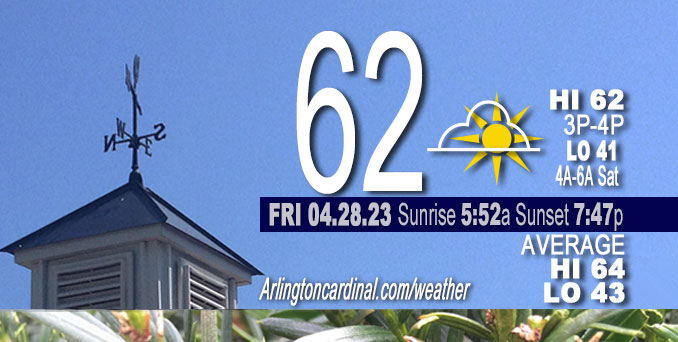
Friday Hi 62, partly cloudy to mostly cloudy, winds N to NE to NW, 5 to 13 to 3 MPH
NWS CHGO | NWS HRLY | /NWSchicago | 🌡
ARLINGTON HEIGHTS WEATHER
▴ forecast7 (Arl. Hts.) | RADAR | WIDE RADAR
⏪ Hrly Data Table | Hrly Future Graph ⏩
IMPORTANT NOTE ON NWS DATA
⏪ Hrly Data Table | Hrly Future Graph ⏩
Hello mobile users! If you encounter a mobile “unfriendly” weather page, turn your phone sideways for a better view.
======================
Friday and Friday Evening …
No Weather Hazards expected …
Partly cloudy beautiful day, slight below normal high temperature.
DISCUSSION…
Focus in the short term is on the potential for light rain early this morning through early afternoon generally east of I-55/57 and the potential for showers and thunderstorms Saturday with the passage of a cold front.
======================
O’HARE FORECAST …
Forecast Beginning Friday, Apr. 28, 2023
Friday: Mostly cloudy, with a high near 62. Northeast wind around 10 mph, with gusts as high as 15 mph.
Friday Night: Partly cloudy, with a low around 42. North northeast wind 5 to 10 mph becoming west after midnight.
Saturday: Showers, mainly after 10am. High near 61. Southwest wind 5 to 10 mph increasing to 10 to 15 mph in the afternoon. Winds could gust as high as 30 mph. Chance of precipitation is 90%. New precipitation amounts between a tenth and quarter of an inch possible.
Saturday Night: A 40 percent chance of showers, mainly after 10pm. Mostly cloudy, with a low around 41. West wind 10 to 15 mph, with gusts as high as 20 mph.
Sunday: Showers likely, mainly after 1pm. Mostly cloudy, with a high near 49. West wind 10 to 15 mph, with gusts as high as 25 mph. Chance of precipitation is 70%.
Sunday Night: Showers likely, mainly before 1am. Mostly cloudy, with a low around 39. Chance of precipitation is 60%.
Monday: Showers likely, mainly after 1pm. Cloudy, with a high near 47. Breezy. Chance of precipitation is 60%.
Monday Night: A chance of showers before 1am. Mostly cloudy, with a low around 41. Breezy.
Tuesday: Partly sunny, with a high near 55. Breezy.
Tuesday Night: Partly cloudy, with a low around 38.
Wednesday: Mostly sunny, with a high near 61.
Wednesday Night: A chance of showers. Partly cloudy, with a low around 44.
Thursday: A chance of showers. Mostly sunny, with a high near 62.


CHICAGOWEATHERSTATION.COM

ChicagoWeatherStation.com I O’Hare Normal Temps/Precip I O’Hare Record Temps, Precip, Snow
WunderMap® with Temperature/Wind Data || Google: Arlington Heights Area Temps | US TEMPS
Midwest Cloud Cover with Arlington Heights Weather Forecast
ChicagoWeatherStation.com I O’Hare Normal Temps/Precip I O’Hare Record Temps, Precip, Snow
SUNLIGHT DATA FOR SECURITY, TRAFFIC SAFETY, AND SPORTS
SunCalc.net data with solar azimuth and trajectory, times for dawn, sunrise, solar noon, sunset, dusk …
NIGHT SKY THIS MONTH …
Backyard stargazers get a monthly guide to the northern hemisphere’s skywatching events with “Tonight’s Sky.” Check the night sky objects for this month and past months in the playlist from the Space Telescope Science Institute YouTube channel (Musical track The Far River written by Jonn Serrie, from the album And the Stars Go With You courtesy of New World Music Ltd).
Get updates from The Cardinal ALL NEWS FEEDS on Facebook. Just ‘LIKE’ the ‘Arlington Cardinal Page (become a fan of our page). The updates cover all posts and sub-category posts from The Cardinal — Arlingtoncardinal.com. You can also limit feeds to specific categories. See all of The Cardinal Facebook fan pages at Arlingtoncardinal.com/about/facebook …
Help fund The Cardinal Arlingtoncardinal.com/sponsor
/////////////>
Area Forecast Discussion
National Weather Service Chicago/Romeoville, IL
603 AM CDT Fri Apr 28 2023
.SHORT TERM… Issued at 250 AM CDT Fri Apr 28 2023
Through Saturday…
Focus in the short term is on the potential for light rain early this morning through early afternoon generally east of I-55/57 and the potential for showers and thunderstorms Saturday with the passage of a cold front.
At this hour, rain has expanded in coverage across central Indiana eastward into Ohio and is trying to expand northwest into northwest Indiana. This has struggled so far thanks to residual dry air in the area per recent AMDAR soundings, though think this will begin to slowly nudge into the area over the next couple of hours and persist through the morning hours into northwest Indiana. It is possible that a few light showers/sprinkles lift as far northwest as Chicago late morning, though confidence in this occurring is still quite low.
There will be a notable temperature gradient from west to east today with highs in the mid-upper 60s along/west of I-39 and mid 50s to lower 60s near the lake and along/east of I-55. This is due to a combination of potential clearing of cloud cover out west and continued cool north northeasterly flow off Lake Michigan. Temperatures tonight will be dependent on the amount of clearing of clouds with the area between weather systems. We have generally leaned on the cooler side of the blended guidance, with lower 40s favored.
As the system responsible for this morning`s rain and cloudiness exits to the east the upper trough will continue to dig across the Plains, the southernmost part likely cuts off across the southern CONUS. Meanwhile the northern stream trough axis is anticipated to push across the area on Saturday with an associated surface cold front bringing our next shot of showers and possibly even a few thunderstorms. The initial band of showers looks to be mainly anafrontal as it moves into northwest Illinois Saturday morning in the wake of the cold front. Some hi-res guidance attempts to develop showers (and possible thunderstorms) closer to the front in the afternoon, likely contingent upon sufficient surface warming given a slower arrival of the front. For only being 24-36 hours out there remains a fair amount of variability in the timing of the cold frontal passage. The slower HRRR/NSSL WRF would allow for temperatures to warm into the mid-upper 60s, whereas a faster solution like the NAM/GFS would suggest we would have less time to warm before the front pushes through. Given the conditional nature of the thunder threat opted to keep them at “slight chance” (20 percent) for Saturday afternoon though did expand the areal coverage generally along and east of I-55. Given fairly stee Plapse rates in place a locally gusty wind threat is possible though the severe weather threat appears low as the better dee Player shear arrives behind the front.
Petr/NWS Chicago
